Research Highlights 2017
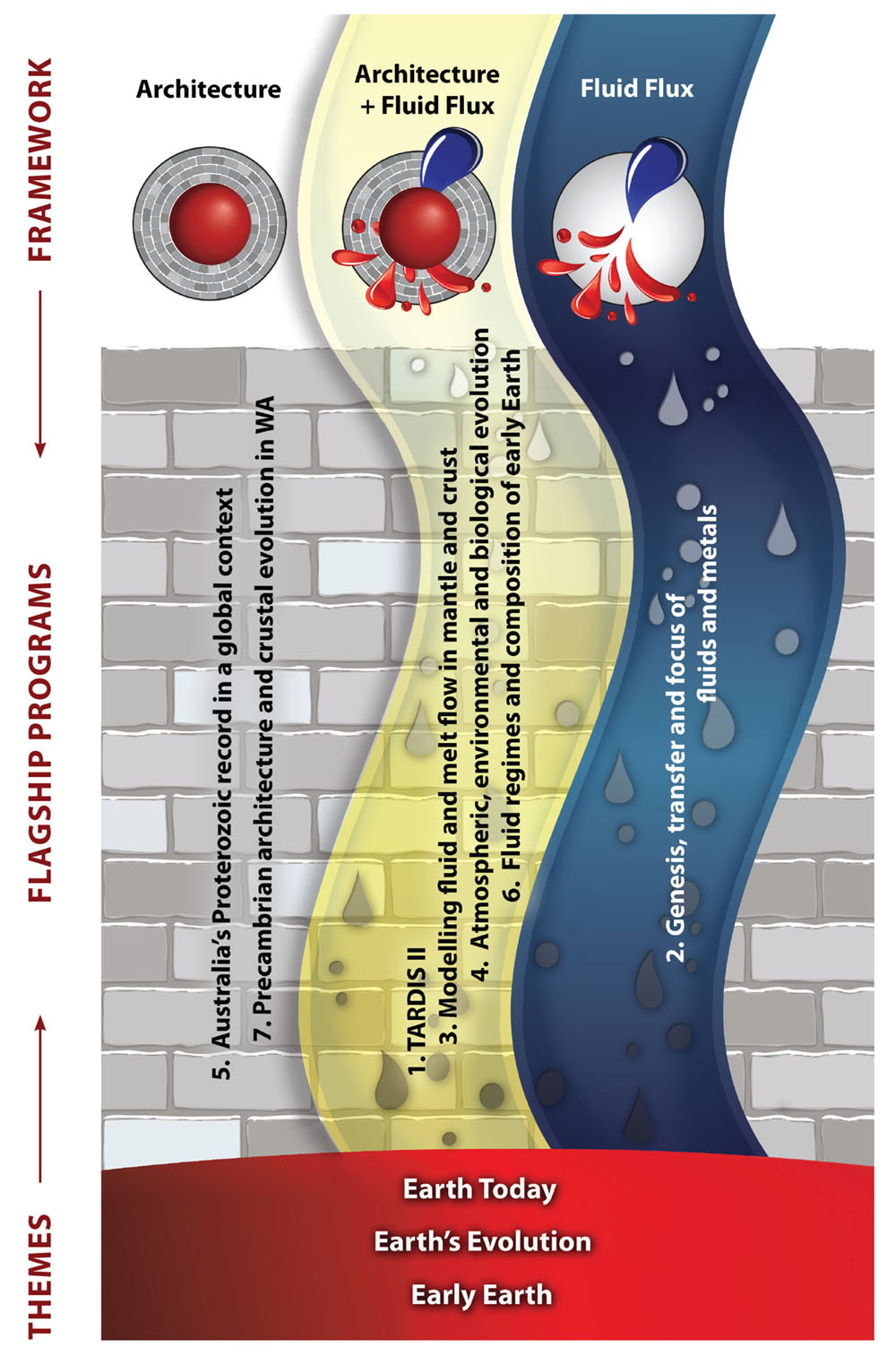
Following the new conceptual framework outlined here, these Research Highlights are identified as contributing to understanding Earth Architecture (the roadmap for fluids) and/or Fluid Fluxes (the “traffic report”), with logos for easy attribution. For a full description of the Foundation Programs, see Appendix 1. and for the Flagship Programs see Appendix 2.
Origins of life: insights from the Pilbara
Currently, there are two principal environments considered as sites for the origin of life. The first is that life began in the ocean in hot vents – a theory that has been favoured since the 1977 discovery of hot seafloor vents thriving with microbial life. The second, and currently gaining traction, is that life began on land in a “warm little pond”, i.e. hot springs on land - a theory first conceived by Charles Darwin.
The Pilbara is an ancient landscape that is barren and rather desolate today, but billions of years ago things were vastly different. The Dresser Formation, located in the East Pilbara, hosts some of the earliest evidence for life on Earth. Stromatolites, i.e. rock structures built by communities of microorganisms, were discovered there in the late 1970s and the site has been a place of interest for research into the early Earth and evolution ever since. Over the past 40 years, the environmental setting has been extensively debated. Original research suggested a quite shallow-water marine environment, resembling the modern Shark Bay, on the West Australian coast. However, since the late 1990s new evidence has pointed to a much more dynamic environment, that of an ancient volcano. What was still unclear about this volcanic setting was the link between life, i.e. stromatolites, and the hot circulating fluids that typically accompany volcanoes. In modern volcanic settings, hot fluids circulate in the underground rocks and manifest either as hot vents at the bottom of the salty ocean such as the black or white smokers, or as terrestrial hot springs where fresh rainwater falls on a land, such as those in Rotorua, New Zealand. This hot circulating water is full of elements liberated from the rocks and becomes a nutrient-rich environment, fertile grounds in which microbes can thrive.
Our recent work in the Pilbara has provided new and strong evidence that terrestrial hot springs had indeed existed within this ancient volcano and, more importantly, could be linked with life. A rock type called geyserite (opaline silica) was found alongside a suite of biological textures including stromatolites. Geyserite is only found in terrestrial hot spring pools and geysers on land. The accompanying biological signatures include a newly-identified microbial texture (called palisade fabric) that represents microbes that grew on the ancient sinter terraces – the rocks that form around hot spring pools. In addition, gas bubbles are inferred to be biological because the preservation of their bubble shape indicates that a sticky substance (microbial) was present that trapped them long enough to be entombed perfectly. All of these textures are almost identical to the fossil textures observed in modern terrestrial hot spring settings today.
Biochemical studies are now showing that some of the reactions necessary to form longer-chain polymers, the more complex molecules needed as ingredients for life, can only occur where dehydration and rehydration are allowed, i.e. in hot pools exposed to air on land.
The findings in the Pilbara provide a geological perspective that lends weight to an origin of life on land, as they extend the record of life living in hot springs on land back to 3 billion years, and indicate that life inhabited the land much earlier (by up to 580 million years) than previously thought.

This project is part of CCFS theme 2, Earth’s Evolution, and contributes to understanding Fluid Fluxes.
Contacts: Tara Djokic, Martin Van Kranendonk
Funded by: CCFS Flagship Program 4, UNSW
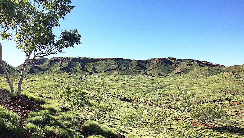
Figure 1. The 3.5 billion year old Dresser Formation, Pilbara, Western Australia.

Figure 2. Cover art for Scientific American, August, 2017 issue relating to article containing Pilbara findings, CCFS publication #1070.
Detective work on stealthy processes in Earth’s mantle solves continental survival, evolution and identity issues
Serial research on, and accumulation of diverse clues about, continental formation can now solve some fundamental questions about when, how, why and where deep processes shaped Earth’s lithosphere.
The lithospheric mantle, the deep part of Earth’s lithospheric plates up to 300 km below the surface, holds many layers of information about the fluids that have risen up from the convecting mantle, and the huge tectonic events that have shaped the outermost part of Earth’s solid shell that we inhabit. It is a palimpsest - just like ancient manuscripts that have many layers of writing superimposed on, and obscuring, earlier messages. Unravelling such repeated fluid episodes from mantle materials brought to the surface as fragments in magmas, or tectonically thrust from depth on to the surface, and remotely sensing the physical properties of the hidden lithosphere with geophysical methods can help solve this great puzzle in deep time and deep space. Interpreting this complex record and tracking specific episodes and processes is a key to reconstructing lithosphere evolution through time and the nature of volatile fluxes from the deep Earth. Convergence between datasets of Hf isotopic model ages for zircons (e.g., Belousova et al., 2010, Lithos) and Re-Os model ages for mantle sulfides (CCFS publication #344), reinforced by other geochemical and tectonic criteria, indicate that over 75% of the subcontinental lithospheric mantle (SCLM) and its overlying crust (now mostly lower crust) formed at 3.0-3.5 Ga, probably in global overturn events that marked a change in Earth’s fundamental geodynamic behaviour (CCFS publication #344).
Pristine Archean lithospheric mantle, the roots of the Archean cratons up to >300 km deep, is not only more depleted (low in basaltic melt components) than younger lithospheric mantle, it is differently depleted. Proterozoic and Phanerozoic lithospheric mantle (xenoliths and orogenic massifs), as well as abyssal peridotites, ophiolitic peridotites, all have one important feature in common: as Al decreases, Fe (and Cr) contents show only a very narrow range (8±1 wt% FeO). In contrast, Archean peridotites have lower Fe at low Al contents, and may show a weak positive correlation between Fe (and Cr) and Al, suggesting that no Cr-Al phase (i.e. spinel or garnet) was present on the liquidus during the melting that produced Archean lithosphere. Garnet-peridotite suite rocks in cratonic mantle are thus now interpreted as products of the metasomatic introduction of garnet and clinopyroxene into original depleted harzburgite, thus ‘refertilising’ the depleted residue.
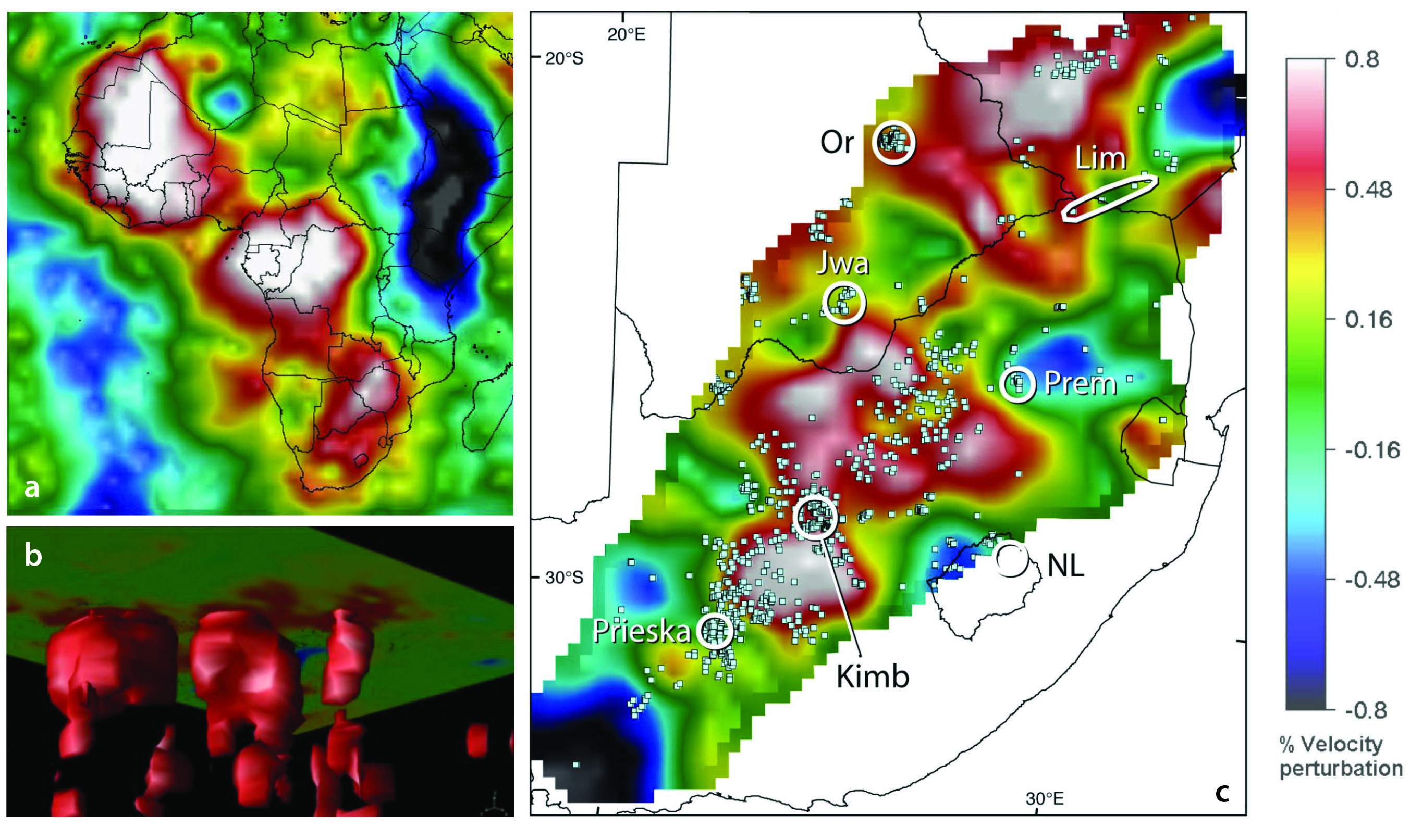
Figure 1. Vs tomography (100-150 km) of the lithospheric mantle. Red to white colours indicate high Vs; blue colours low Vs (modified from CCFS#207 and Begg et al., 2009, Geosphere). (a) Africa, showing distribution of the boundaries of high-velocity cratonic blocks with metasomatised (red) margins. (b) modelled high-Vs irregular volume of cratonic roots to ~350 km beneath each craton. (c) Detailed seismic tomography for Kaapvaal craton with kimberlites clustered at margins of high-velocity volumes. White circles show major kimberlite provinces.
Therefore, the traditional ‘oceanic melting trend’ is now interpreted as a refertilisation trend, with the compositional trend arrow reversed (Griffin et al., 2009, J Pet). The cratonic roots in contact with the convecting part of the mantle (the asthenosphere) and outer margins in contact with repeated fluid and melt fluxes, are the most strongly modified domains through time, so cratonic root compositions show a general increase in fertility (e.g., increasing Fe, Ti, Ca, Al content and decreasing Mg content) with increasing depth.
Integration of geochemical and geophysical datasets, groundtruthed with petrophysical measurements and modelling for different mineral compositions and modes, has enabled us to interpret global (and regional) seismic tomographic results with an increasing degree of geological reality (Fig. 1).
Stealth metasomatism and its geophysical significance
Mantle metasomatism is the process, and the results, from the interaction of fluids with mantle rocks they pass through. This affects not only the geochemical characteristics of the lithospheric mantle, but also its physical parameters (and hence geophysical signatures) including density, seismic response and thermal and electrical characteristics. The concept of ‘stealth’ metasomatism was introduced (CCFS publication #5; 2012 Research Highlight) to highlight the ‘deceptive’ addition to lithospheric mantle rock-types of new minerals (e.g. garnet and/or clinopyroxene) indistinguishable mineralogically from common mantle-peridotite phase assemblages.
Recognition of stealth metasomatism reflects the increasing awareness of the importance of refertilisation (resulting in, for example, higher Fe, Ca and many minor- and trace-element contents) of ancient refractory mantle regions by deep-seated fluid fronts.
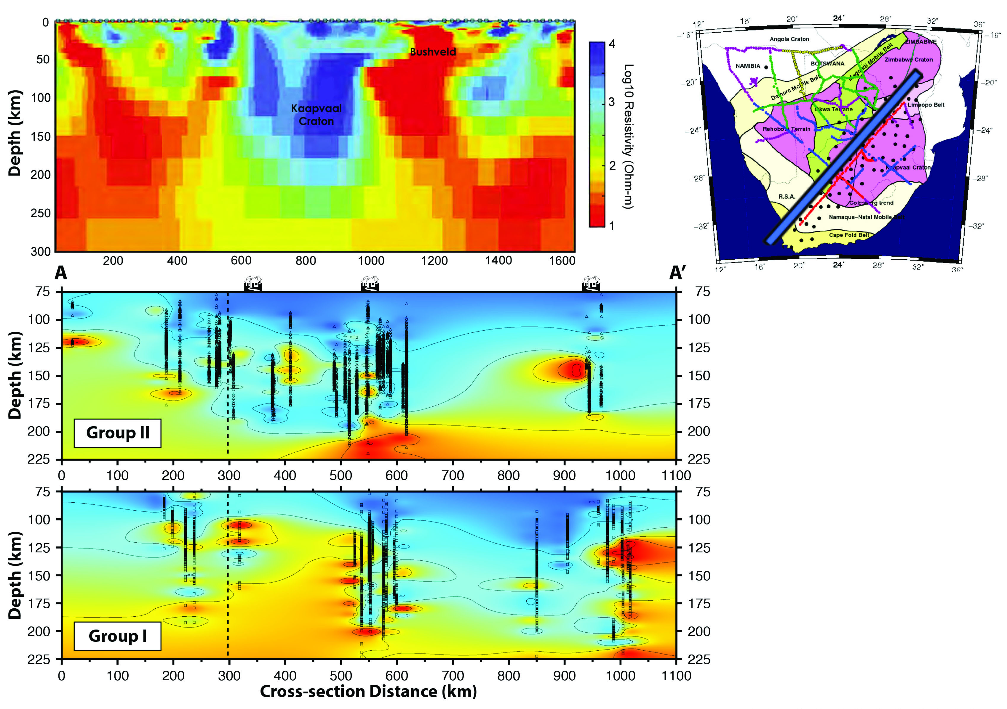
Figure 2. Upper image shows MT data for the Kaapvaal traverse from Jones et al., 2011, JGR. Inset shows traverse line. Lower images show metasomatic intensity across the same traverse at ~150 Ma (top) and 90 Ma (lower), after Kobussen et al., 2008, Geology 36.
Understanding the timing and nature of stealth metasomatism is critical to understanding the geochemical and geodynamic evolution of different regions of the lithospheric mantle and also for assessing their metallogenic fertility.
Primitive Archean lithospheric mantle is highly magnesian (~49% MgO) with lower density (~3.31 g/cm3) than fertile mantle (~3.37 g/cm3). The resulting contrasts in seismic response become measurable if metasomatised regions are on the scale of tens to hundreds of km. Metasomatic refertilisation of the cratonic lithospheric mantle not only increases its density, but also strongly affects its rheology. The recognition that the cratonic lithospheric mantle may in general consist of a very depleted upper layer, becoming more metasomatised (evidenced by garnet peridotites) at depth, provides a solution to some important discrepancies between geophysical data and numerical models. A deep cratonic root made up mainly of garnet peridotites would imply a lower geoid and a much greater elevation than is observed for the Kaapvaal craton, and a mismatch in Vp/Vs ratios (Afonso et al., 2010), but a layered model with refertilisation increasing with depth, yields numerical models that fit the geophysical data.
Thermal changes are caused by advective transfer of heat by relatively hot metasomatising fluids and by the influx of heat-producing elements (K, U, Th) that accompanies some types of metasomatism. Radioactive decay of these elements can raise the local heat flow by 50-70% over normal reduced mantle heat flow. The origins of significantly contrasting electromagnetic (MT) responses in the lithospheric mantle have not yet been satisfactorily identified. Fluid-related recrystallisation demonstrated in microstructural studies may result in significant H contents in mantle minerals and may affect electrical conductivity. The key to understanding the electromagnetic signals from the mantle lies in identifying the nature of fluids, their oxidation state, and their distribution and thus is closely connected with a full understanding of metasomatic processes, grain sizes and fabrics, and fluid compositions and movement mechanisms in the mantle. Comparisons of high-resolution MT traverses with geochemical mapping traverses show a correlation of higher conductivity with more strongly metasomatised domains.
The 2-D isotropic model of magnetotelluric response across the Kaapvaal Craton is shown in the top image, Figure 2 (Jones et al., 2011, JGR); the traverse locus is marked in the inset map. The lower 2 images show the contoured metasomatic intensity for domains beneath the same Kaapvaal traverse line in 2 time slices. This is measured using geochemical parameters of mantle-derived garnets carried to the surface in Group II kimberlites (upper panel) at around 150 Ma; the lower panel shows analogous results for garnets from Group I kimberlites (at around 90 Ma). Hotter colours show higher metasomatic intensity: the most highly metasomatised regions for the younger traverse (lower panel) coincide with regions of higher conductivity (lower resistivity).
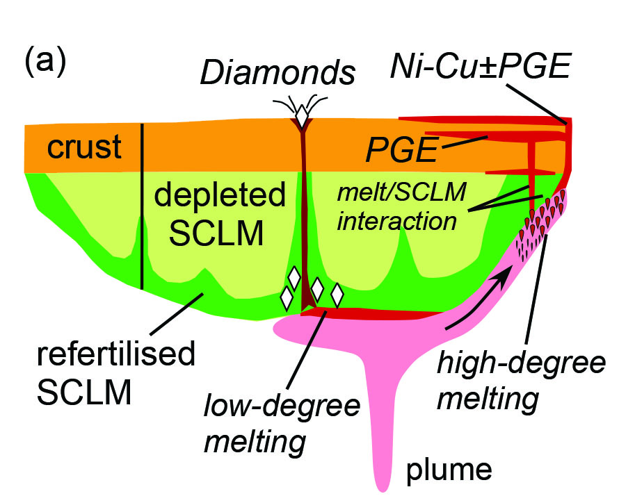
Figure 3. Interactions between magmas and the base and edges of cratonic roots. Plume magmatism triggers kimberlite formation and flows to areas of thinner SCLM where melting is focused. Variable interaction of melts with crust and SCLM influences Ni-Cu and PGE deposit genesis. Lithosphere-scale discontinuities and zones of weakness can focus the locus of kimberlite eruption. (Adapted from CCFS publication #207)
Implications for metallogeny
Magma-related ore systems form economic deposits that underpin our human civilisation. The magmas related to metallic element redistribution derive from the asthenosphere, then traverse and interact to varying degrees with the subcontinental lithospheric mantle. The evolution of the original Archean lithospheric mantle has been the single largest influence on the formation of most of Earth’s ore deposits (CCFS publication #207):
• the high degree of buoyancy of this ancient SCLM relative to the asthenosphere, results in the persistence today of low-density, rheologically coherent Archean domains and commonly, the preservation of old crustal (or at least lower- crustal) domains;
• the enduring (and volumetrically dominating) Archean lithospheric mantle domains are a reservoir for metasomatic enrichment over their long history, creating a potentially metallogenically-fertile mantle impregnated with critical elements (e.g., Au, Cu, Ni and PGEs; Fig. 3)
• the formation of Archean cratons provided an architectural mantle-scape of regions with contrasting rheology, composition and thickness. These cohesive Archean domains direct magma and fluid pathways around their margins and along old sutures between blocks, and may act as both sinks and sources for ore-forming elements depending on the geodynamic evolutionary stage;
• if the first stabilisation of lithospheric mantle at 3.0-3.5 Ga signalled the end of a mantle overturn regime (either uniquely, or intermittently with subduction), then this is when long-lived tectonic regimes conducive to mineralising systems (e.g., back-arc basins, passive margins, cratonic boundaries) became available (http://ccfs.mq.edu.au/AnnualReport/13Report/ResHigh.html#GLAM).

This project is part of CCFS theme 2, Earth’s Evolution, and contributes to understanding Earth’s Architecture and Fluid Fluxes.
Contacts: Sue O’Reilly
Funded by: CCFS Flagship Program 1
A piece of America lingers in northern Australia: Legacy of the 1.6-billion-year-old supercontinent Nuna
Figure 1. Current ripple laminations in fine to medium grained sandstone sedimentary rocks in Georgetown indicate ancient shallow marine environments. Our data shows these sediments were deposited off the coast of North America adjacent to present-day Canada, and later transferred to Australia.
Throughout Earth’s 4-billion-year history, as continents have shifted around the globe, they periodically have amalgamated to form supercontinents. Most recently this occurred about 300 million years ago to form the supercontinent Pangea, in which the southern continents (Africa, South America and Australia and Antarctica) were connected to Eurasia and North America. We now recognise that an earlier supercontinent termed Nuna formed about 1.6 billion years ago. Although previous researchers have speculated that north-east Australia was near North America, Siberia, or North China within the framework of Nuna, solid evidence has been hard to find.
Approximately two thirds of the Australian continent consists of basement rocks older than 600 million years. In North Queensland, rocks 1.7 billion years old are found in Mt. Isa and 500 km away in the Georgetown region. New sedimentological field data, in conjunction with new and existing geochronological data from both regions, have revealed an unexpected component of the Australian continent. As expected, Mount Isa rocks show strong resemblances to known Australian basement rocks. However, the age spectra of zircons from sedimentary rocks in the Georgetown area (Fig. 1) revealed signatures previously unknown in Australia. Instead, they show strong resemblance to spectra from sedimentary rocks in present-day Canada, sourced from American basement rocks (Fig. 2).
The simplest explanation for our findings is that 1.7 billion years ago, when the Georgetown rocks were deposited in a shallow sea, the area was part of North America. It was then rifted away from North America, and only collided with the Mt Isa region of northern Australia at around 1.6 billion-years ago when almost all continents on Earth at the time assembled to form the Nuna supercontinent (Fig. 2). When Nuna broke apart some 300 million years later, the Georgetown area remained permanently stuck to Australia.
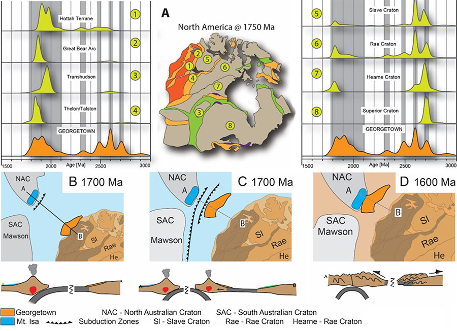
Figure 2. A) Detrital zircon spectra from the Georgetown sediments have multiple overlaps with magmatic ages from North America, suggesting an ancient link. B) Sediments now in Georgetown (orange) are believed to have been deposited off the coast of North America. C) An east-dipping subduction system caused Georgetown to be rifted away from North America about 1.7 billion years ago. D) Roughly 100 million years later, the Georgetown block was accreted to north- eastern Australia, and has stayed there ever since. This Australia-Antarctica-North America unification by ~1600 Ma signifies the completion of the assembly of Nuna.
In Mount Isa we find evidence of mountains being built as Georgetown collided with the rest of Australia. Interestingly, this mountain belt, in contrast to the Himalayas, would not have been as large. To explain this, we have evoked a double-sided subduction model. Another possibility is that the Earth during this period was hotter and was unable to support the immense mountain belts we see on the modern Earth.
This project is part of CCFS theme 2, Earth’s Evolution, and contributes to understanding Earth’s Architecture.
Contacts: Adam Nordsvan, Zheng-Xiang Li, Earth Dynamic Research Group, Curtin University
Funded by: ARC Laureate Fellowship ZX Li, Curtin University scholarship AR Nordsvan
Buoyant Ni-Cu-PGE-bearing magmas trapped deep in continental crust
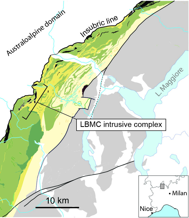
Figure 1. Figure 1. Generalised geologic map of the Ivrea Zone, showing the location of the LBMC intrusive complex within a section of lower continental crust that is tilted steeply SE, exposing amphibolite- to granulite-facies metasedimentary rocks (yellows) that are interleaved and intruded by mafic and minor intermediate igneous rocks (green).
The formation of magmatic Ni-Cu-PGE ore deposits depends on the ascent of high-degree partial melts from the mantle into the crust. Such deposits are commonly found along crustal-scale discontinuities that provide favourable pathways for mantle-derived magmas, such as translithospheric faults, sutures and rifts (CCFS publication #207). While this association has been demonstrated at the scale of tectonic plates, the mechanisms that govern magma flux within these zones of favourable structure remain poorly understood. Particularly little is known about the emplacement of ore-forming magmas in the deep crust because access to crustal roots is limited.
The Ivrea Zone in the NW Italian Alps (Fig. 1) is a natural laboratory to examine mechanisms of magma ascent and arrest near translithospheric structures. Exhumation and tilting of continental crust has exposed a suite of mineralised mafic and ultramafic intrusions, the La Balma-Monte Capio (LBMC) intrusive complex, emplaced into host rocks at a paleodepth of 20-30 km. Collectively, these rocks preserve a continuous cross section of lower- to middle crust adjacent to a long-lived tectonic boundary between the Europe and Adria plates. The mineralised suite comprises several elongate ultramafic bodies, with a cumulative width of at least 9 km and thickness of 400 m, that are inferred to be the products of in situ differentiation of a high-Mg magma. Recent high-precision geochronology has revealed the mineralised bodies were emplaced at 200 Ma, overlapping with the onset of rifting at the plate boundary, and considerably later than the crystallisation of the host rocks.
A key finding is that the LBMC intrusive complex was emplaced at a rheological transition in lower continental crust, where granulite-facies gabbro is overlain by a package of paragneiss of similar metamorphic grade. Differences in bulk composition and mineralogy between the gabbros and overlying gneisses produce a significant density contrast at this transition. To evaluate the role of this pre-existing density contrast in trapping mafic and ultramafic magmas in the lower crust, we produced a 1D density model of the lower Ivrea Zone crust. The model incorporates published bulk densities for gabbros (n=40) and overlying granulite-facies gneisses (n=17). Densities were calculated for a range of estimated primary melt compositions (n=13) for the LBMC igneous complex, using Gibbs Free Energy minimisation and thermodynamic modelling based on empirically determined P-T parameters and the PerpleX software.
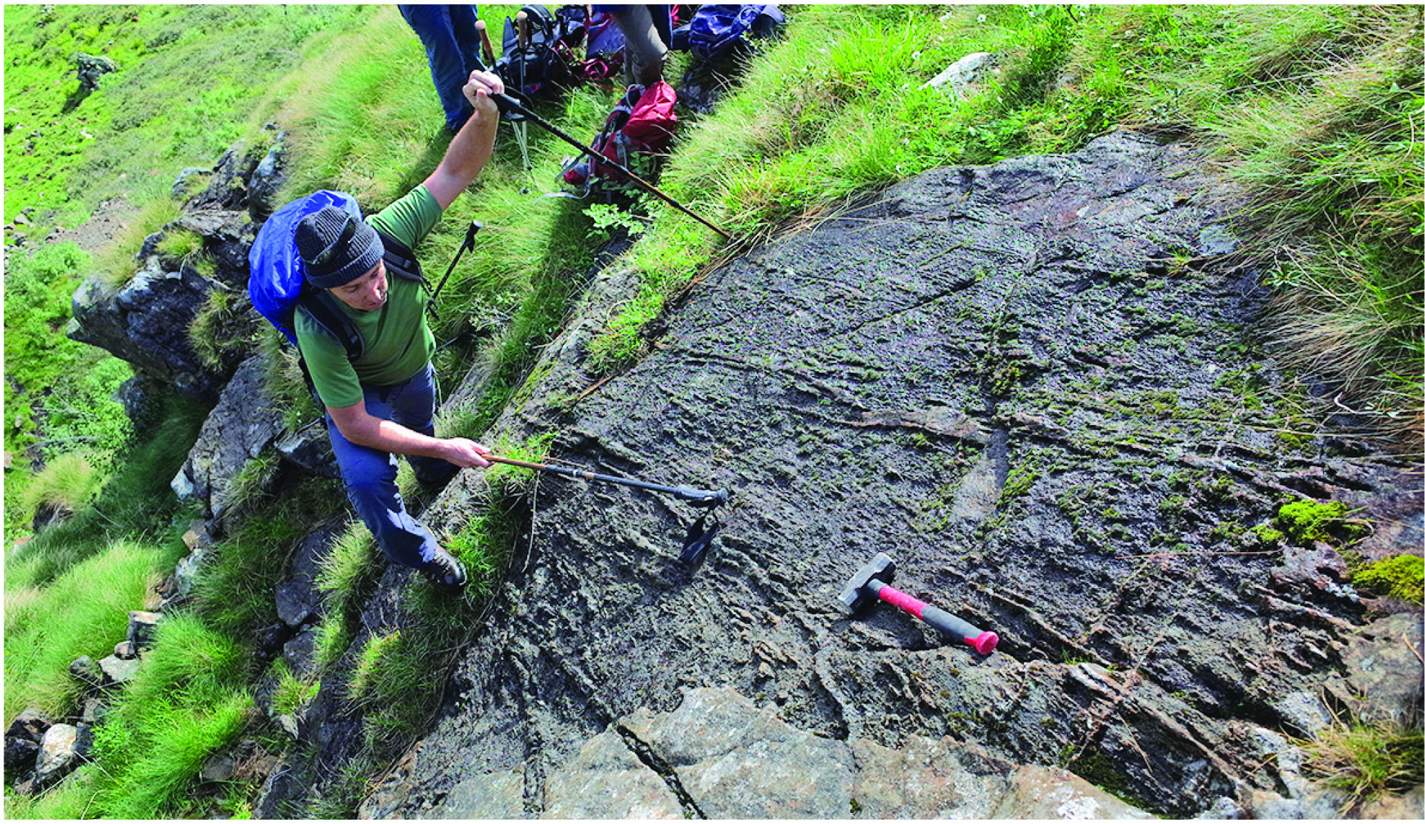
Marco Fiorentini examines intrusive relationships between Ni-sulfide-bearing peridotite (bottom) and gabbros (centre) near the roof of the LBMC igneous complex (Photo: Greg Dering).
The results showed a significant range of overlapping densities at fixed P-T conditions for each of the three modelled components. Because this variation is the result of measured bulk rock compositions, it is probably representative of the natural variation in density within the lower crust. The mean calculated density of the La Balma parental melt (2810 kg/m3) is less than the mean densities of both the footwall gabbros (3190 kg/m3) and hanging wall felsic gneisses (2990 kg/m3). Model results (Fig. 2) show that there is a 2.9-8.5% likelihood that estimated parental melt matches the calculated footwall gabbro densities, and a 24.6% probability that bulk rock densities match those of the felsic wall gneisses. These results show that an emplacement scenario in which neutral buoyancy plays a role is only significant within areas characterised by particularly low-density granulite. In most scenarios covered by the model, parental melts maintain an internal vertical driving force that would be expected to carry the magma to significantly shallower crustal levels. The fact that the LBMC intrusive complex, and associated Ni-sulfide mineralisation, lies at this surprisingly deep level suggests that the internal buoyancy force of magma can be counteracted by mechanical and/or stress barriers over length scales of kilometres. Seismic velocity profiles indicate such physico-chemico transitions to be a relatively common feature of continental crust, particularly in extended terranes. Consideration of lower-crustal composition and structure should be incorporated into conceptual models of magma transport close to tectonic sutures; such models have historically emphasised sub-vertical pathways.
This project is part of CCFS theme 3, Earth Today, and contributes to understanding Earth’s Architecture and Fluid Fluxes.
Contacts: Gregory Dering, Marco Fiorentini, Christopher Gonzalez, Jonathan Munnikhuis
Funded by: CCFS Flagship Program 2
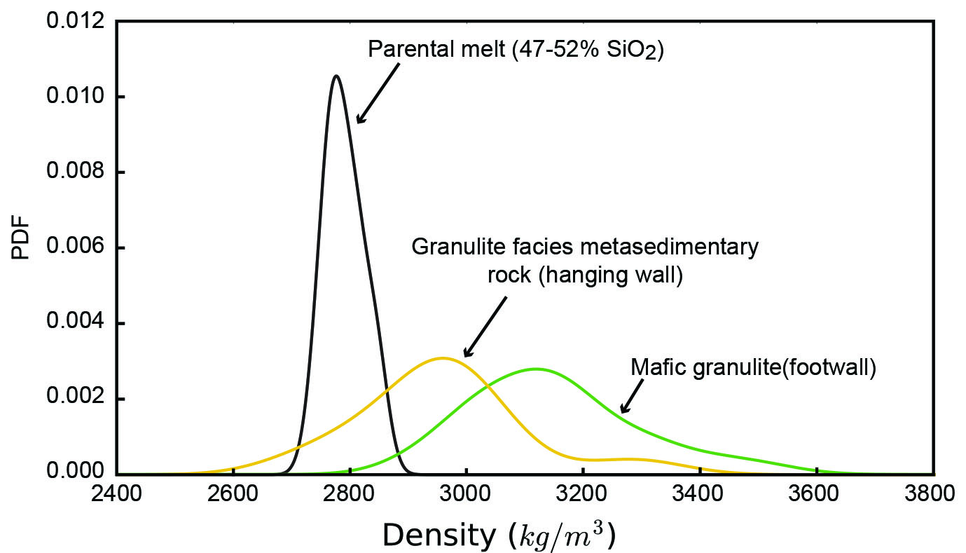
Figure 2. Kernel-density estimation for modelled physical densities of host rocks and parental melt compositions from the Ivrea Zone. The wide range of rock densities modelled for both metasedimentary and mafic granulites reflects heterogeneity in bulk composition found throughout the Ivrea Zone.
Monitoring the evolution of gold-bearing fluids
∆33S anomalies (∆33S > ±0.2‰) were formed in the Archean, largely through mass independent fractionation of sulfur isotopes (MIF-S) in an oxygen-poor atmosphere, and imparted to the Archean supracrustal rock record (as MIF-S). This indelible MIF-S0 signature can be used to trace sulfur pathways to orogenic gold deposits. Through this recycling process, the original MIF-S signal (∆33S ≠ 0‰) may be diluted by mixing between sulfur reservoirs to such an extent that it becomes undetectable (∆33S = 0±0.5‰). In such cases, interpretation of the geological significance of such isotopic signatures may be compromised, mass-dependent isotopic fractionation of sulfur isotopes (MDF-S, recorded as δ34S) can yield small ∆33S values (±0.2‰), often owing to biological reactions involving sulfur.
In this project, we have reassessed the quantification of ∆33S due to MDF-S from the traditionally accepted 0±0.2‰ value (Farquhar and Wing, Earth Planet Sci Letters, 2003), and demonstrated that its magnitude is not constant but rather is directly linked to the degree of δ34S fractionation. The analysis of these results and of a data compilation from ~2.65 Ga orogenic gold deposits of the Yilgarn Craton indicates that ∆33S values are too large to be the result of purely MDF-S processes; at least some of the sulfur must be derived from Archean sedimentary rocks. A compilation of >3400 ∆33S measurements of Archean sedimentary rocks shows highly variable positive and negative signals, whereas the gold deposits have remarkably constant ∆33S values between 0 and +0.6‰. This strongly suggests that the auriferous fluids equilibrated at depth by mixing sulfur from Archean sedimentary rocks with sulfur from a reservoir with no MIF-S signature. These outcomes significantly enhance the power of MIF-S (∆33S) as a tracer of sulfur pathways through the lithosphere.
Orogenic hydrothermal gold systems often show a large spread in δ34S because sulfur isotopes are sensitive to changes in pH, P, T, ƒO2, ƒS2. We are focusing on harnessing this variation in a spatially and temporally constrained hydrothermal architecture to understand the precipitation mechanisms of metals carried in fluids. By monitoring the isotopic evolution of a hydrothermal fluid in space and time, we can better understand the changes in thermochemistry that lead to metal precipitation from a fluid, and apply this as a vector toward mineralisation. For example, at the 6 Moz Waroonga orogenic gold deposit of the Yilgarn Craton, both ∆33S and δ34S have been used to document that the source of sulfur in the system remained constant. The sulfide chemistry suggests that Au precipitation was driven by an abrupt change in the redox state of the ore fluid (captured in the δ34S values of the mineralisation sequence).
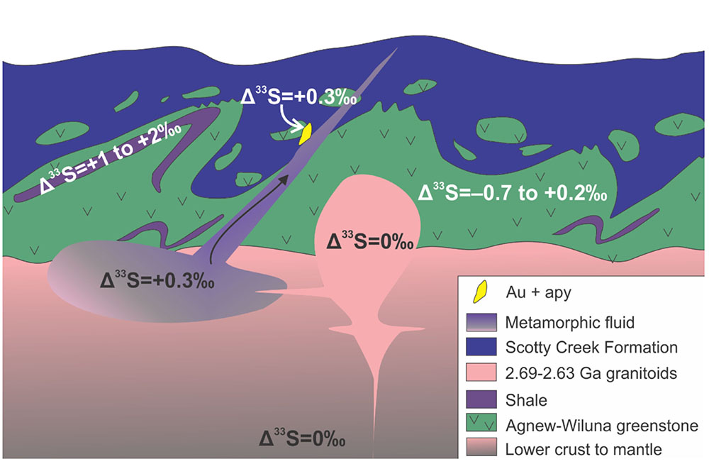
Figure 1. Schematic model demonstrating hypothesised sulfur reservoirs for Archean orogenic gold deposits in the Yilgarn Craton.
This project is part of CCFS theme 2, Earth’s Evolution, and contributes to Understanding Earth’s Architecture and Fluid Fluxes
Contacts: Crystal LaFlamme, Nicolas Thebaud, Dennis Sugiono, Marco Fiorentini, Stefano Caruso, Heejin Jeon, Vikraman Selvaraja
Funded by: MRIWA
Southwestern Africa on the burner
Cenozoic volcanism is widespread in Africa; prominent examples are the Eastern African Rift System (EARS), the Cameroon Line, Darfur, Hoggar, Tibesti and the Moroccan Atlas (Fig. 1). The magmas commonly are derived from the mantle and range from carbonatitic and mafic alkaline to differentiated silica-rich magmas. A profound lithospheric control on intraplate volcanism is indicated by 1) association of volcanism with terrane boundaries and/or thin lithosphere; 2) cyclicity of magmatic activity in the same regions over >100 Myr; 3) synchronicity across the African plate; and 4) absence of clear age progression patterns. Conversely, a major role for mantle convection is supported by the coincidence of Cenozoic volcanism with regions of lithospheric uplift, positive free-air gravity anomalies and slow seismic velocities. With evidence for tectonic, lithospheric and convective controls, the ultimate trigger(s) of mantle-derived Cenozoic intraplate volcanism in Africa remains unresolved.
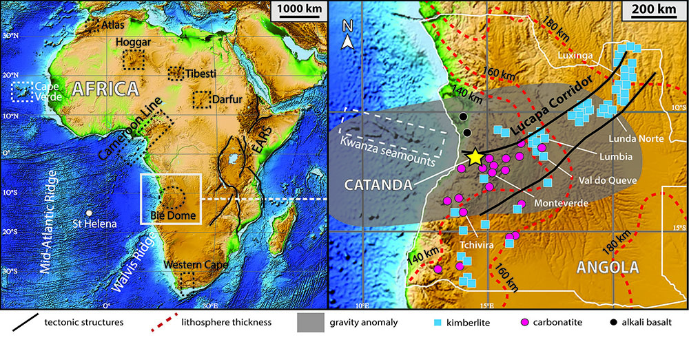
Figure 1. Elevation map of the African plate with inset showing location of the Catanda Complex and major Triassic and Cretaceous kimberlite, carbonatite and alkali basalt occurrences. Grey shaded area indicates free- air, crust-corrected gravity anomaly. Dashed red lines are estimates of the lithospheric thickness.
To improve constraints on the genesis of African volcanism, we and our colleagues at the University of Melbourne, Tasmania, Barcelona (Spain) and Luanda (Angola) have documented the age and isotopic composition of the Catanda Volcanic Complex (Figs 1 and 2), which hosts the only extrusive carbonatites in Angola. Apatite (U-Th-Sm)/He and phlogopite 40Ar/39Ar ages of Catanda lavas indicate eruption at ~500–800 ka (Fig. 3), >100 Ma after emplacement of abundant kimberlites and carbonatites in this region. The young age of the Catanda lavas is consistent with other evidence for recent volcanic and geothermal activity in the area, including well-preserved volcanic landforms (Fig. 2) and ongoing hydrothermal activity. These observations imply a recent resumption of volcanic activity in western Angola, some 90 Ma after emplacement of mafic alkaline dykes in the area. The lavas share HIMU-like Sr-Nd-Pb-Hf isotope compositions with other young mantle-derived volcanics from Africa (e.g., Northern Kenya Rift; Cameroon Line).
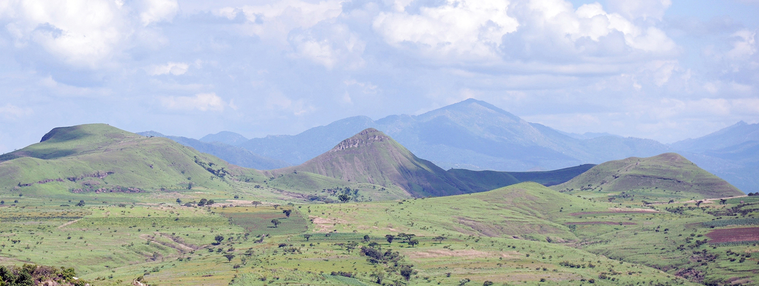
Figure 2. View of the Catanda Volcanic Complex (Angola).
The position of the Catanda complex in the Lucapa corridor (Fig. 1), a long-lived extensional structure, coupled with recent seismic activity in the Catanda area suggests a possible tectonic trigger for the volcanism. The complex is also located on the Bié Dome (Fig. 1), a broad region (~1000 km in diameter; ~2500 m of elevation) of rapid Pleistocene uplift attributed to mantle upwelling. Seismic-tomography models indicate convection of deep hot material beneath regions of active volcanism in Africa, including Angola and northern Namibia. The rapid Pleistocene uplift, the occurrence of positive free-air gravity anomalies (Fig. 1), seismic tomography and mantle convection models all support active mantle upwelling beneath the area and make a purely tectonic trigger for mantle-derived magmatism unlikely. We suggest that rapid uplift of the Bié Dome and attendant Catanda carbonatitic volcanism in the Pleistocene might be related to a finger-like low-velocity structure, a branch of the South African Superplume that is rising beneath southwestern Africa. Thinned lithosphere beneath the Lucapa corridor and especially its western sector (Fig. 1) would provide a preferential pathway for focusing mantle upwelling.
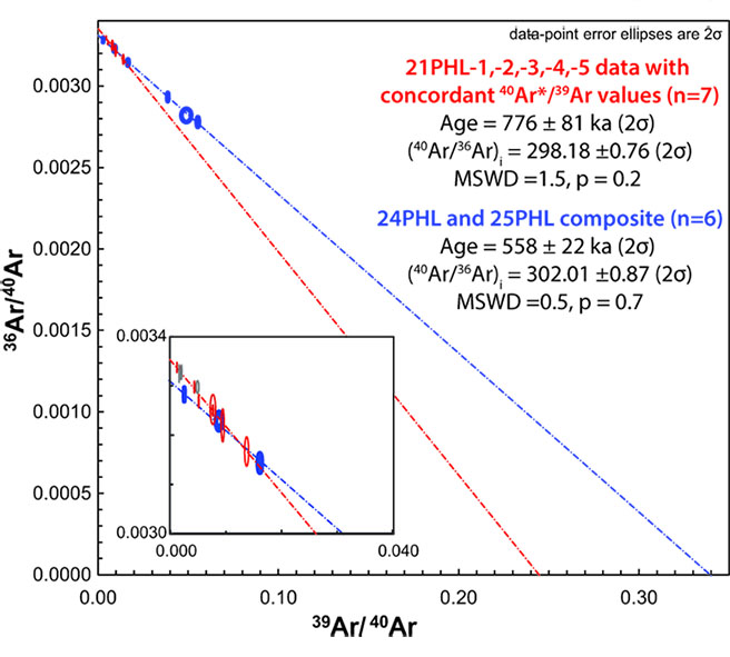
Figure 3. 40Ar/39Ar phlogopite inverse isochrons providing ages for the Catanda lavas.
While the Catanda complex and other expressions of late Cenozoic intraplate volcanism in Africa (e.g., EARS, Cameroon Line, Darfur, Hoggar, Tibesti, Moroccan Atlas) correlate with pre- existing lithospheric discontinuities, they also show evidence of being affected by active mantle upwelling. Therefore, intraplate carbonatitic and alkaline magmatism probably results from the complex interplay between multi-scale mantle convection and pre-existing lithospheric structures.
This project is part of CCFS theme 2, Earth’s Evolution, and contributes to understanding Earth’s Architecture and Fluid Fluxes.
Contacts: Andrea Giuliani, Juan Carlos Afonso
Funded by: ARC DECRA
A trapped fossil oceanic slab in NW China
The fate of subducted oceanic slabs can provide important clues to plate reconstruction through Earth history. However, an ancient oceanic slab, stalled in the lithosphere at the end of subduction, is unlikely to be well-preserved for long, due to the subsequent tecto-thermal events (magmatism in particular). The western Junggar region, situated in NW China (Fig. 1), is an ideal place to study the evolutionary history of the Central Asian Orogenic Belt (CAOB). This region is characterised by Paleozoic ophiolites, volcanic rocks and many valuable Cu-Au ore deposits, along with three large-scale NE-striking faults, the Hatu, Karamay-Urho and Darbut faults (Fig. 1). Particularly along the more than 200-km-long Darbut Fault and the hidden Karamay-Urho Fault, lenses of ophiolitic mélanges crop out. Extensive Late Paleozoic magmatism and deformation occurred in this region and across the entire CAOB. The tectonic origin of the western Junggar is believed to be related to either intracontinental or intra-oceanic arc-related subduction systems which developed in the early Paleozoic and ended in the late Paleozoic. However, the mode of subduction is still contentious. Based on geological and geochemical studies, several competing models of the subduction have been proposed, including northwestward subduction, a double-sided subduction and subduction of an oceanic ridge. These different models would predict different crustal structure. Thus, imaging the crustal structure at high resolution may help to discriminate among the competing models.
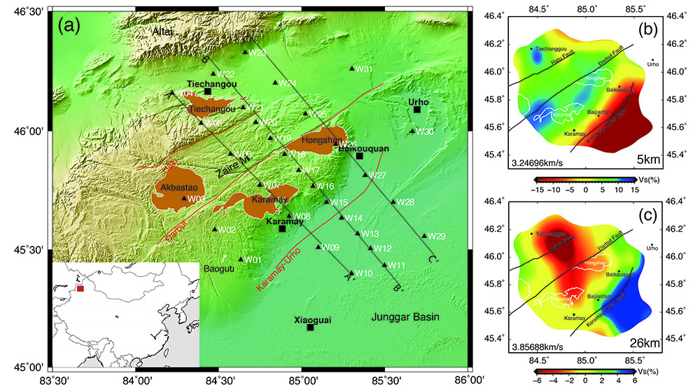
Figure 1. (a) Tectonic setting of the western Junggar region. The red lines indicate three major faults, black triangles indicate the locations of seismic stations, and the orange areas represent major intrusions. (b) and (c) S-wave velocity anomaly maps at 5 and 26 km depth from surface wave tomography with reference velocity of 3.247 km/s and 3.857km/s, respectively.
We have generated a shear wave velocity model of the crust in western Junggar based on data from an array of 31 portable broadband seismic stations. According to our model, large Vs contrasts are observed in the shallow crust between the Junggar basin and the Zaire mountain, with the boundary following the hidden Karamay-Urho Fault (K-U fault). Low-Vs anomalies dominate the upper crust beneath the Junggar basin with the velocity varying from ~1.5 km/s in the surface to ~3.0 km/s around 10 km depth. To the northwest of the K-U Fault, relatively high S-wave velocities (>3.5 km/s) are seen in the upper crust beneath the Hongshan and Karamay intrusions. At depths of ~20 km, the patterns of shear velocities anomalies are very different from those in the upper crust. Very high S-wave velocities (3.7-4.1 km/s) occupy most of the area beneath the Junggar basin (Fig. 1c).
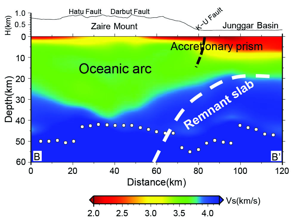
Figure 2. Vertical cross-section of S-wave velocities and our interpretation of a well-preserved fossil oceanic slab along BB’ shown in Figure 1a.
In our velocity model the body with high shear-wave velocity is nearly flat beneath the western Junggar basin and dips gently northwestward. This geometry probably reveals a SE-to-NW fossil subduction beneath the western Junggar, consistent with the interpretation of MT results (Xu et al., 2016). It appears that a fossil subducting oceanic slab and an intra-oceanic arc system are well preserved in the Darbut belt. The interpretation of the high velocity body as a remnant oceanic plate is also supported by our CCP imaging as shown in Fig. 2, where a clear Moho offset is visible slightly to the right beneath the Karamay-Urho fault. This Moho offset is likely to associated with the paleo- subduction interface, and the K-U fault can be interpreted as one of the major thrust faults separating the arc from the accretionary prism in the southeast. The zone without high velocities, between the western Junggar basin and the Zaire mountains, can be interpreted as the forearc accretion wedge, corresponding to the depression of the Moho interface. The distribution pattern of S-wave velocities strongly supports the model of a subduction zone which failed to be underthrust during the late Paleozoic and has been preserved ever since.
This project is part of CCFS theme 3, Earth Today, and contributes to understanding Earth’s Architecture.
Contacts: Shucheng Wu, Yingjie Yang
Funded by: NSFC 41530319 and 41374079, CCFS Flagship Program 3
Distinctive aberrant geochemical fingerprints for Ancient SCLM in collision zones
Pyroxenites are more abundant in the lower crust of volcanic arcs and in sub-arc mantle than in most other mantle tectonic environments. The petrological processes responsible for their formation and evolution may play a key role in the development of chemical and isotopic heterogeneities in the mantle.
However, their contribution has remained poorly constrained due to their complex petrogenesis and the uncertainty about the extent of their recycling. In the Cabo Ortegal Complex, Spain (Fig. 1A), abundant pyroxenites, associated with dunites and harzburgites, have formed by fractional crystallisation and melt/ peridotite interaction after picritic and/or boninitic melts (Fig. 1B, C), probably in a sub-arc mantle.
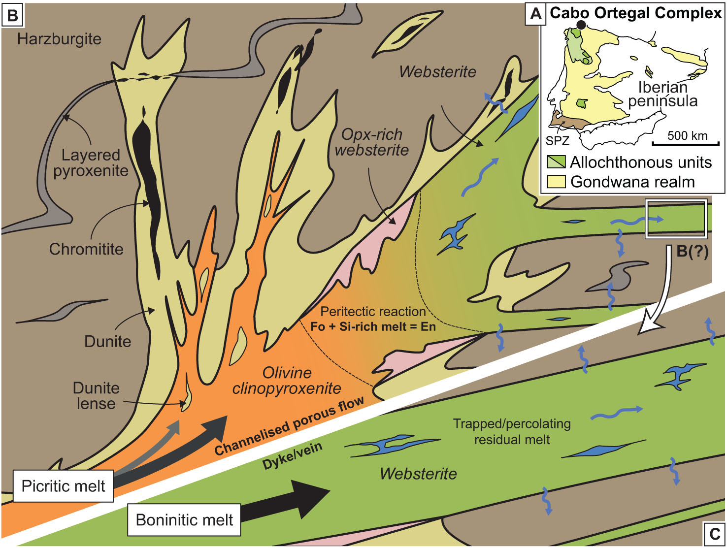
Figure 1. Location of the Cabo Ortegal Complex in the Variscan belt of the Iberian Peninsula (A) and conceptual petrogenetic model for Cabo Ortegal pyroxenites, dunites and chromitites, assuming an initially picritic (B) and boninitic melt (C).
Based on the availability of a robust tectonothermal, petrologic and geochemical background, we have applied Lu-Hf and Re-Os isotopic systematics to clinopyroxene, amphibole, and whole- rock samples from Cabo Ortegal pyroxenites and associated peridotites and chromitites. Our data show that the pyroxenites are characterised by uncorrelated 176Lu/177Hf and 176Hf/177Hf (0.2822-0.2855) and a wide range of 187Re/188Os and 187Os/188Os (0.16-1.44).
While Sm-Nd geochronology indicates that the pyroxenites probably formed during Cadomian arc magmatism (421-762 Ma), strikingly decoupled Nd- and Hf-isotope compositions (Fig. 2) along with EM I-like Sr and Nd signatures (87Sr/86Sr(t) = 0.7037-0.7045 and εNd(t) = 0.3-7.5) suggest a contribution from the sub-continental lithospheric mantle (SCLM), probably during the development of the arc on a continental margin. This is in good agreement with old Hf and Os (TMA) model ages, and Re-Os (0.6-1.0 Ga) and Lu-Hf (1.1 Ga) isochron ages. In addition, cpx and amphibole exhibit a slight disequilibrium in terms of Hf isotopes, indicating a partial resetting of the system during amphibolitisation and the multi-stage nature of this process. Some amphibole growth is ascribed to the exposure of sub-arc mantle to a Devonian subduction zone, probably leading to sub-solidus reactions under granulite- to amphibolite-facies conditions, and to the remobilisation of Re, as evidenced by correlations between amphibole content, LREE enrichment and 187Re/188Os.
Despite these isotopic perturbations, we show that different sections of a progressively LREE- enriched sample preserve apparent Sm-Nd, Lu-Hf and Re-Os isochrons that predate metamorphic amphibolitisation. This may reflect a relatively short distance of isotopic equilibrium arising from differential elemental and isotopic diffusivities during melt transport. We suggest that this transient phenomenon may be characteristic of (pyroxenite- forming) melt-peridotite interactions during the reworking of old continental lithosphere by arc magmatism. The recycling of arc pyroxenites may thus potentially account for the ubiquitous observation of decoupled Hf and Nd isotopes in the lithospheric mantle, consistent with the extensive preservation of Archean SCLM.
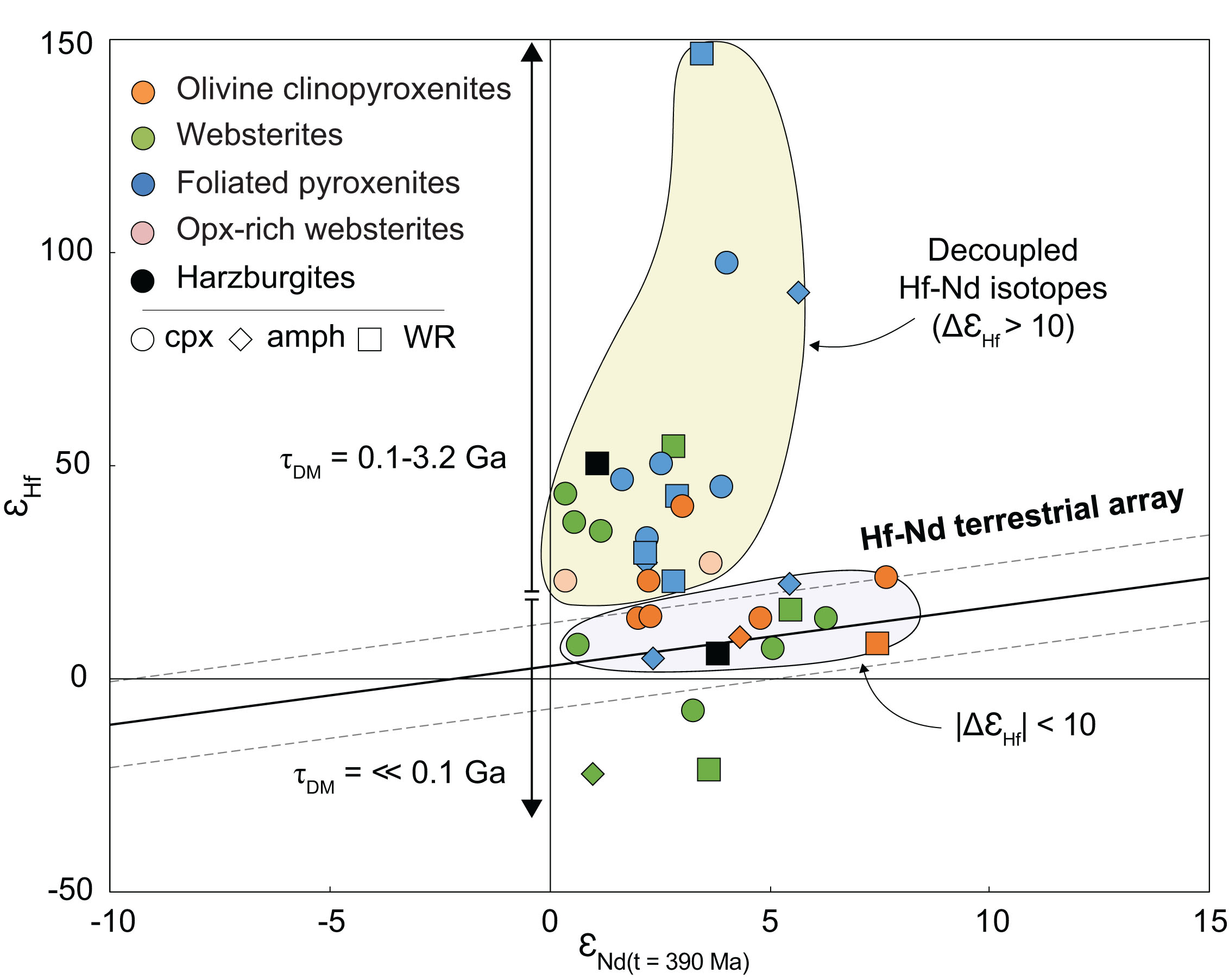
Figure 2. Decoupled Hf-Nd isotopes measured in Cabo Ortegal pyroxenites. ΔεHf corresponds to the vertical distance to the terrestrial array in ε notation; corresponding Hf model ages (ΤDM) are also shown.
This project is part of CCFS themes 2 and 3, Earth’s Evolution and Earth Today, and contributes to understanding Earth’s Architecture and Fluid Fluxes.
Contacts: Romain Tilhac, Georges Ceuleneer (Géosciences Environnement Toulouse, GET, France), Sue O’Reilly, Bill Griffin
Funded by: CCFS Flagship Program 1
Crustal Evolution of the Albany-Fraser Orogen
The Albany-Fraser Orogen is a NE-SW trending Paleoproterozoic to Mesoproterozoic orogenic belt that lies wraps around the southern margin of the Yilgarn Craton (Fig. 1). Previous interpretations of the tectonic setting of the Albany-Fraser Orogen invoked the accretion of exotic or suspect terranes, but recent U-Pb geochronology, whole-rock geochemistry, Hf -and Nd-isotopic datasets have radically refined our understanding of the orogen. Recent work suggests that the Albany-Fraser Orogen contains no exotic components but formed through the episodic addition of juvenile magmas into the existing Archean crust of the Yilgarn Craton, in a series of events that overprinted but did not obliterate the original Archean signature.
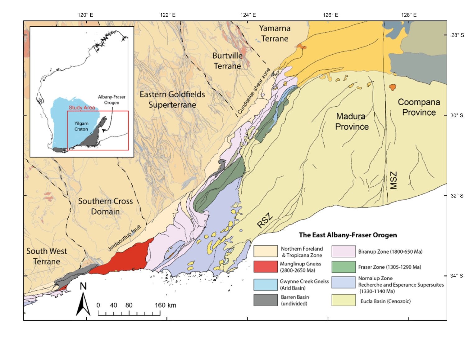
Figure 1. Geological Map of the Albany-Fraser Orogen showing the location of the study area.
Heterogeneity in the composition of granitic magmas is influenced by both large-scale lithospheric architecture and magma-generation processes (both related to geodynamic setting) as well as the composition of the crustal substrate. To test the influence of these processes on magma compositions we use zircon hafnium-isotopic compositions and whole-rock geochemistry from granitic rocks associated with a period of Paleoproterozoic magmatism called the Biranup Orogeny (1730-1650 Ma). A map of the median εHf of zircons from the Paleoproterozoic magmas of the Albany-Fraser Orogen shows a similar pattern to the variation in the large-scale structure of the Yilgarn Craton (Fig. 2). Sr/Y ratios of these granitic magmas are uniformly low along the length of the orogen, implying that crustal thickness was uniformly thin (ca 15 km) along the margin of the Yilgarn craton during this period in geological time (Fig. 3).
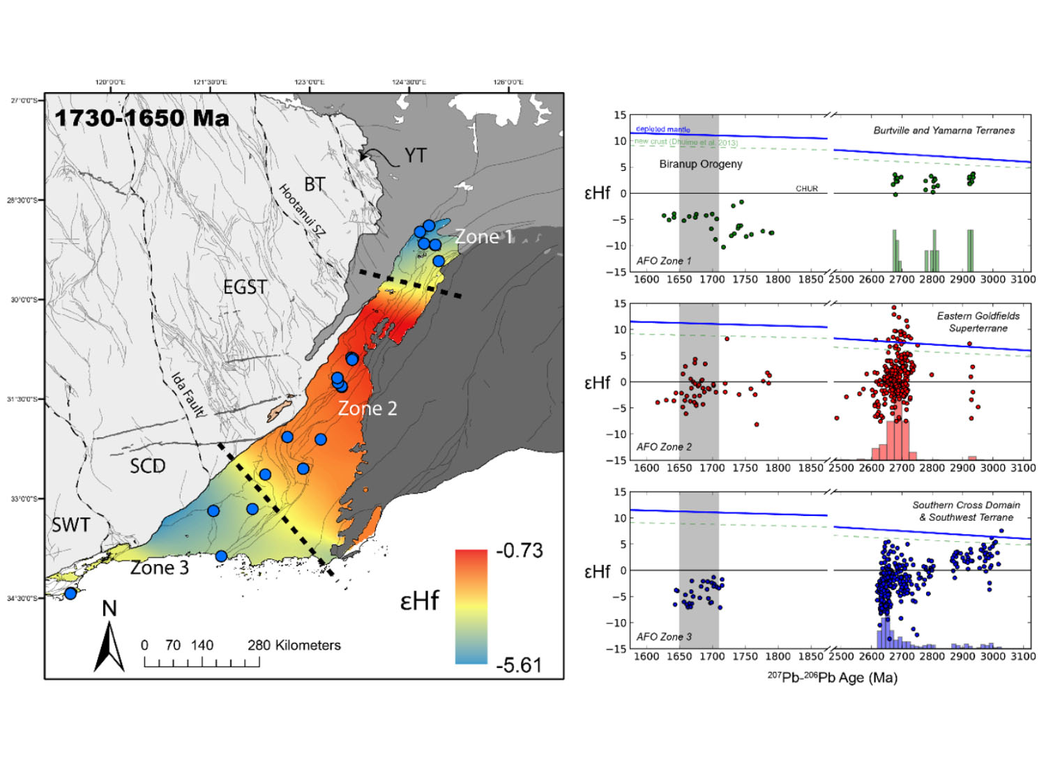
Figure 2. Map of zircon εHf of Paleoproterozoic (1700-1650 Ma) granitic magmatism along the Albany- Fraser Orogen. Heterogeneity in zircon hafnium- isotope compositions reflects the large- scale heterogeneity and architecture of the adjacent Yilgarn Craton.
Thus, we conclude that the heterogeneity in the composition of zircons from the granitic rocks of the Biranup Orogeny largely reflects the regional-scale heterogeneity of the Archean basement terranes that were reworked to produce the Paleoproterozoic magmas, and not by large-scale variations in lithospheric architecture or crustal thickness. These data provide a means of visualising and tracking the influence of different basement terranes through space and time.
This project is part of CCFS theme 1, Earth’s Evolution, and contributes to understanding Earth’s Architecture.
Contacts: Michael Hartnady, Chris Kirkland, Chris Clark
Funded by: CCFS Flagship Program 7
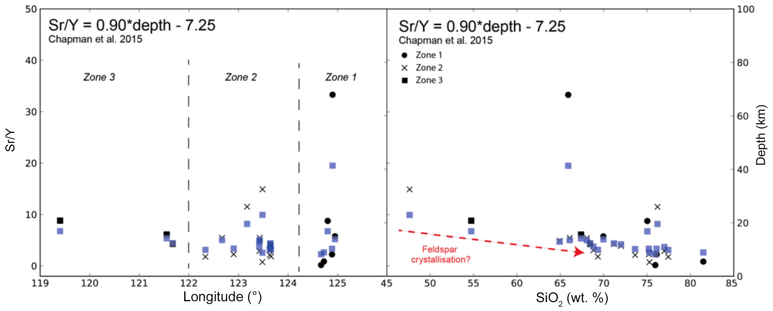
Figure 3. Plots of Sr/Y for the Paleoproterozoic magmas show uniformly low values along the length of the Albany-Fraser Orogen. This implies that crustal thickness was uniformly thin along the margin of the Yilgarn Craton during this period in time.
El Dorado in El Indio Belt, Chile-Argentina
This project aimed to understand the structure of one of the most highly Au-endowed provinces of the Andes Cordillera: the Miocene El Indio Belt (EIB).
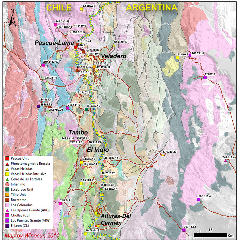
Figure 1. U-Pb zircon age of samples considered for zircon O-isotopes and Lu-Hf analyses on this project.
This 150 km x 100 km metallogenic camp located in the Chilean-Argentinean Andes Cordillera hosts >45 Moz Au, mostly in world- class Au-Ag epithermal deposits (Pascua-Lama, Veladero, El Indio-Tambo District and the most recent discovery, Alturas). It provides a natural laboratory to study the trans-lithospheric architecture that provided the magma/fluids/gold pathway and the architecture’s geodynamic evolution related to metallogenic events.
The project is divided into several components, including surface structural mapping, geophysical (mainly magnetometry and gravity) reinterpretation, and geochemical analysis. Targeted geochronology and partial isotopic mapping (O-isotopes) using zircons help define the crustal architecture into which the Au deposits have been emplaced.
Both the Permian-Triassic granitic basement and Cenozoic intrusives or in situ domes (related to Au-Ag mineralisation) in Chile and Argentina were sampled for zircon analyses. U-Pb SHRIMP-II geochronology, O-isotopes and Lu-Hf LA-ICP-MS analyses are being performed.
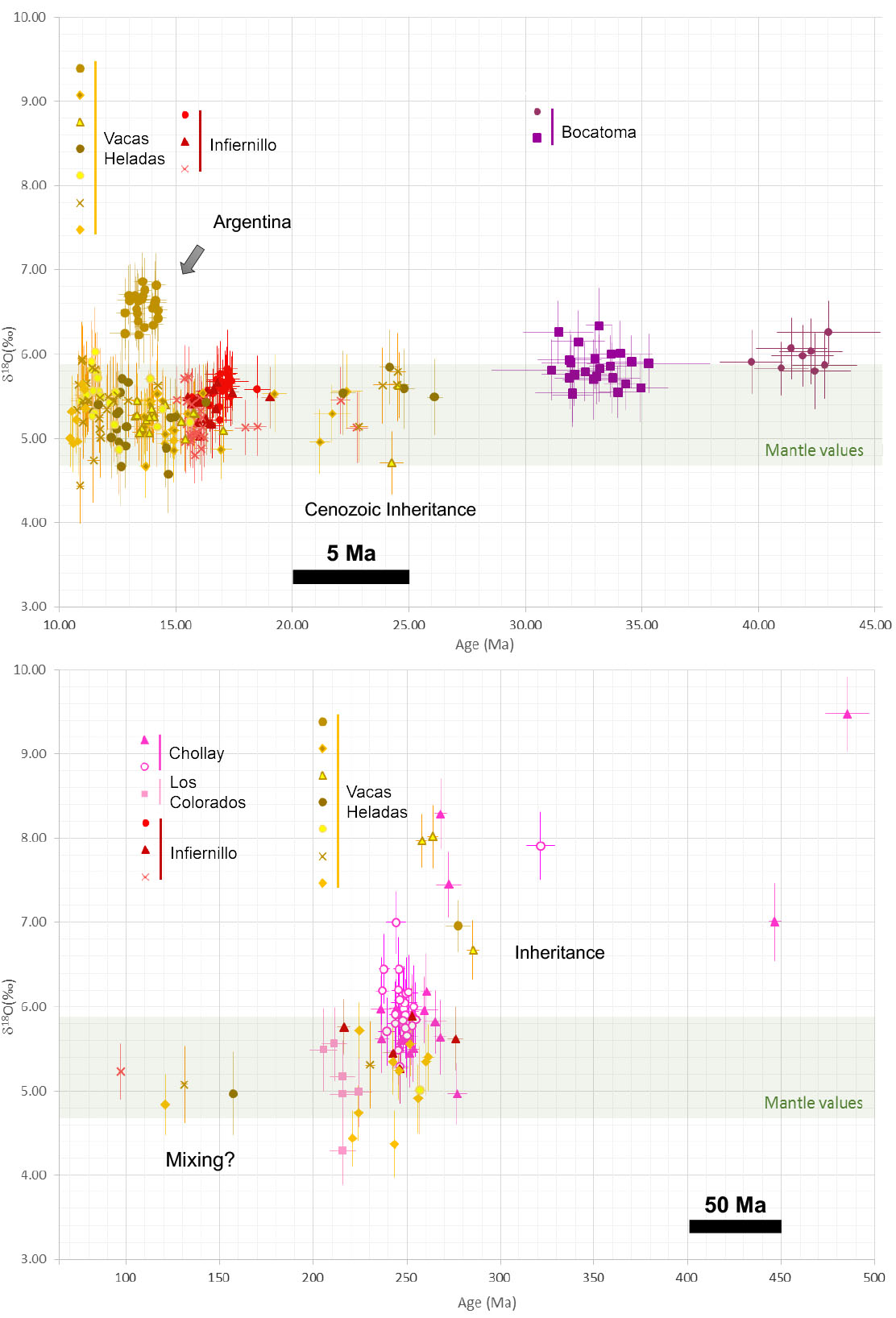
Figure 2. δδ18O vs U-Pb zircon age plot for each sample analysed spots. 10 to 500 Ma timespan, note change of timescale at 50 Ma. Error bar in 2σ.
Preliminary results on the O-isotopes show a marked difference between zircons from Permian-Triassic basement rocks and zircons in Cenozoic magmas of the El Indio Belt. Basement zircons have high δ18O (a crustal signature), and the oldest inherited cores of all samples show the highest crustal component. Zircons from early Cenozoic magmas all show a strong crustal component, but the zircon O-isotope signature becomes more mantle-like during the Oligocene to Miocene, with almost no crustal component in the later magmas.
Significant variations in age and O-isotopic signatures are observed between the E and W domains of EIB. Late magmas in the Argentinian area of the EIB show higher δ18O, probably indicating a greater degree of crustal involvement in the east, where the crust may be thicker and older. The preliminary data suggest a large N-S structure separates the two domains, and appears to survive the subsequent Cenozoic events.
The goals of this project are to stimulate new approaches to identifying new Au-rich provinces at early stages, by recognising key trans-lithosphere structures.
This project is part of CCFS theme 2, Earth’s Evolution, and contributes to understanding Earth’s Architecture.
Contacts: Constanza Jara, John Miller (CSIRO), Marco Fiorentini, Heejin Jeon, Mark Fanning (ANU), Diego Winocur (UBA)
Funded by: Barrick Exploration
Fieldwork in the Argentinean Andes, El Indio Belt project (Constanza Jara).
Pyroxenite layering in the upper mantle and how to find it
Seismic waves reveal information on the interior of the Earth because their travel times reflect a complex combination of temperature, mineralogy, composition and the presence of melt or fluid along their trajectory. Because of the way minerals deform when subjected to stress, an alignment of the minerals develops during deformation and new bulk elastic properties arise. This process will give rise to a fast and a slow velocity direction for elastic waves travelling through the deformed rock (i.e., an anisotropy). Based on seismic data, seismologists can compute the anisotropy of the different seismic waves in the upper mantle domains. Their interpretation has been traditionally focused on the most volumetrically significant mineral (i.e., olivine) despite the fact that pyroxenites make up significant proportions in specific mantle domains. However, correctly understanding seismic data requires the determination of the seismic properties of a pyroxenite-rich domain to account for their effect on the resulting seismic signal. Following up on our previous research, we used the Herbeira massif, Cabo Ortegal, Spain as an example of a pyroxenite-rich domain from Earth’s upper mantle. As the structure of Herbeira is not homogeneous, a new modelling protocol that incorporates the effects of this specific layered geometry was developed.
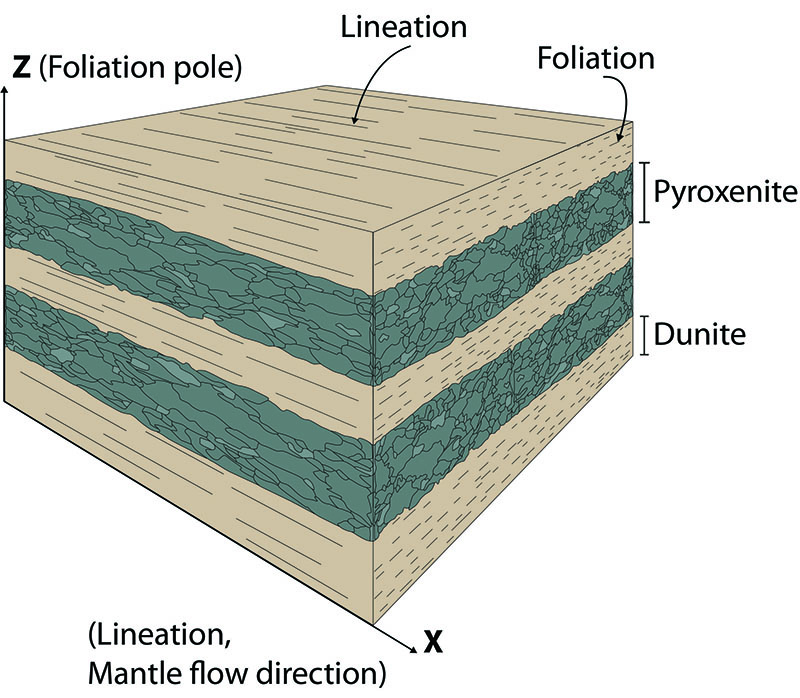
Figure 1. Typical outcrop of layered pyroxenite in the Herbeira massif. The dark green layers (pyroxenites) alternate with brownish layers (dunites).
This new calculation approach, combined with the data from Herbeira, allowed us to model a realistic supra-subduction upper mantle domain infiltrated by subduction-related melts.
The modelled seismic properties of a pyroxenite-rich domain similar to the Herbeira massif are comparable to that of common supra-subduction material (e.g., harzburgite xenoliths from the Kamchatka volcanoes) but will induce specific signal deviations in the anisotropic spectrum.
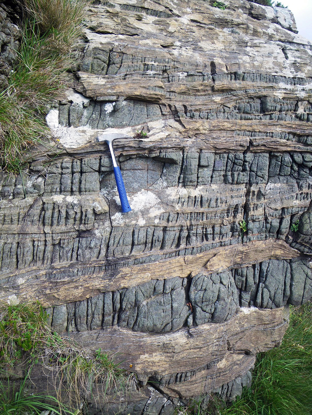
Figure 2. A simple sketch of the layered model, which assumes a continuous and parallel layering.
Along the volcanic front of subduction zones, down in the mantle wedge, a switch of the P-wave Fast-Velocity Direction (FVD) from trench-normal to trench-parallel is documented in seismic databases. Our model shows that the presence of layered pyroxenite complexes in this specific region is consistent with this large-scale observation. Although the model may not account for the whole switch, its observed sharpness could reflect the presence of pyroxenite. Large volcanic fronts can extend laterally for 200 km or more along the arc collision zone. Mantle pyroxenitic layering similar to that of Herbeira along this front, would delay P-waves travelling perpendicular to the arc strike by more than 0.4 sec, which is measurable.
We also have characterised the specific deviations that a layered pyroxenite-rich domain would have on the different shear waves and have recognised a seismic fingerprint for these kinds of domain, which potentially can be used to identify the presence of pyroxenites in subduction zones. This could be a starting point to bridge the gap between geophysical observations and isotope geochemistry in understanding the contribution of pyroxene-rich lithologies to the genesis of mantle-derived magmas in many tectonic environments, as well as potentially using seismic-velocity signatures to track paleo-subduction domains that have been infiltrated by fluids, thus forming pyroxenites.
This project is part of CCFS themes 2 and 3 and Earth’s Evolution and Earth Today, and contributes to understanding Earth’s Architecture and Fluid Fluxes.
Contacts: Hadrien Henry, Beñat Oliveira, Romain Tilhac, Sue O’Reilly, Bill Griffin, Georges Ceuleneer (Géosciences Environnement Toulouse, GET, France)
Funded by: CCFS Flagship Program 1, iMQRES, EPS postgraduate funds, cotutelle program - Paul Sabatier University, CNRS
The oldest rocks formed by microbes: unexpected diversity
Microbialites are rocks produced by microbial life, and they commonly preserve fossils of some of Earth’s earliest lifeforms – stromatolites. The microbialites of the 2.4 Ga Turee Creek Group, first reported in 2016, include the earliest known expression of clotted microbial growth in the rock record; clotted microbialites (or thrombolites) are preserved amongst stromatolites in a 300 m thick dolomite-carbonate reef. CCFS-funded research in 2017 has allowed for a more detailed examination, which has revealed that these clotted microbialites are far more diverse in both morphology and microtextures than previously realised.
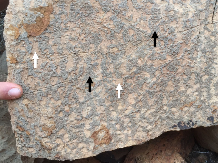
Figure 1. Interconnected thrombolitic texture with the microbial framework (blue-grey colour, black arrows) surrounded by dolomite sand (tan colour, white arrows).
A total of three main types of clotted microbialite have been identified and described, two of which are new to the locality:
1. Clotted microbial aggregate: this texture is an aggregate of isolated fine-grained clumps of microbial carbonate, each enveloped by coarse carbonate cement, that appears to have buried stromatolites. These clumps contain preserved traces of kerogen, identified using Raman spectroscopy, which confirms their biological origin. The microbialite is not benthic but an aggregate that probably formed when clumps of microbial material settled out from the overlying water column and were rapidly cemented. This is the only clotted microbial texture that had previously been described from this locality.
2. Lobate thrombolites: these structures have the gross morphology of a stromatolite but lack internal layering. Preserved bedded sediment and marine precipitates fill the intercolumn space between individual thrombolites and indicate that primary textures have not been destroyed by diagenetic fluids; this indicates that the thrombolitic textures are also primary. These represent the earliest thrombolites with bioherm morphology, more than 400 Ma older than other examples.
3. Interconnected thrombolitic textures: these are comprised of an interconnected microbial framework of fine to medium carbonate with interstitial spaces filled by either carbonate sediment or marine cement. They are found in beds and mounds, and often have a gradational contact with stromatolitic units above and below. These thrombolites have morphologies that otherwise are only known from much younger (Neoproterozoic and Phanerozoic) rocks.
Figure 2. XPL image of interconnected thrombolitic texture. Microbial carbonate (dark, fine grained) is encased by a coarsely bladed marine cement. The microbial portion contains preserved kerogen. Image width: 1 cm.
These discoveries add to the already diverse range of microbialites in the Turee Creek Group and supplement newfound diversity in deep-water microfossil communities and in problematic siliceous structures from shallow-water facies at the same locality. When considered alongside these other discoveries, the clotted microbialites of the Turee Creek Group represent just one facet of an apparent explosion in biotic complexity at 2.4 Ga, the driver of which is still under investigation.
This project is part of CCFS theme 1 Early Earth, and contributes to understanding Earth’s Architecture and Fluid Fluxes.
Contacts: Brendan Nomchong, Martin Van Kranendonk
Funded by: CCFS Flagship Program 4
Supercontinent Nuna formed in two stages
While there exists a general consensus regarding the configuration of the Earth’s youngest supercontinent, Pangea, much uncertainty still surrounds that of arguably the oldest supercontinent, Nuna. Recent work suggests Nuna’s final assembly was not completed until ca 1600 Ma, and that the preceding interval of ca. 2000-1700 Ma might represent a time when the building blocks of Nuna, including proto-Laurentia, proto-Australia and proto-Baltica, were assembled.
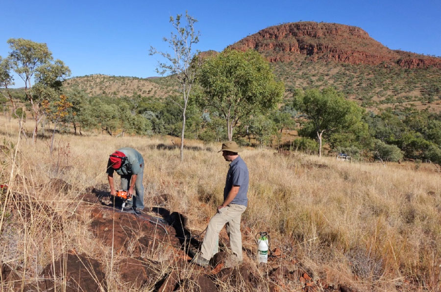
Figure 1. Sampling of the Hart Dolerite (low outcrop in the foreground) that intrudes the Paleoproterozoic Kimberley Group (cliff in the background) (Photo: Zheng-Xiang Li).
Current paleomagnetic constraints are still insufficient for establishing a detailed paleogeography for this assembly process. This is especially true for one of the key continent- continent connections in building Nuna, the speculated connection between western Laurentia and eastern proto- Australia. A 1976 preliminary study of the ca 1.8 Ga Hart Dolerite in the eastern Kimberley craton, north-western Australia, showed some promising results, although a subsequent study in 2008 in western Kimberly proved to be less successful. We undertook a meticulous sampling of the Hart Dolerite from the eastern Kimberley craton (Fig. 1), which yielded well defined paleomagnetic directions with dual polarities. A comparison of our resulting paleopole with other Australian poles for the period of 1800-1600 Ma indicates that proto-Australia, as a whole, underwent only very minor amounts of plate motion during that time. Our new results, along with existing data, also support the previously interpreted 40° intracontinental rotation between the North Australia and South Australia cratons during the Neoproterozoic (see 2011 CCFS Research highlights).
A comparison of the Australian poles with that of Laurentia for the time between 1800 Ma and ~1400 Ma yielded more important findings: there are two distinct segments in the apparent polar wander paths (APWPs) of both continents for that time interval, suggesting similar movements of the two continents during these two time intervals. Comparable APWPs between 1800 Ma and 1730 Ma imply that the two continents were already close to each other then and shared similar plate motions (Fig. 2a). This was followed by a ca. 1000 km relative plate motion between them before ca. 1650 Ma, leading to the final assembly of Nuna by ca. 1600 Ma. The two continents as a core part of Nuna again shared common APWP after 1650 Ma that lasted at least until ~1400 Ma (Fig. 2b). We therefore suggest that there was a two stage assembly between Australia and Laurentia as part of the assembly of the supercontinent Nuna.
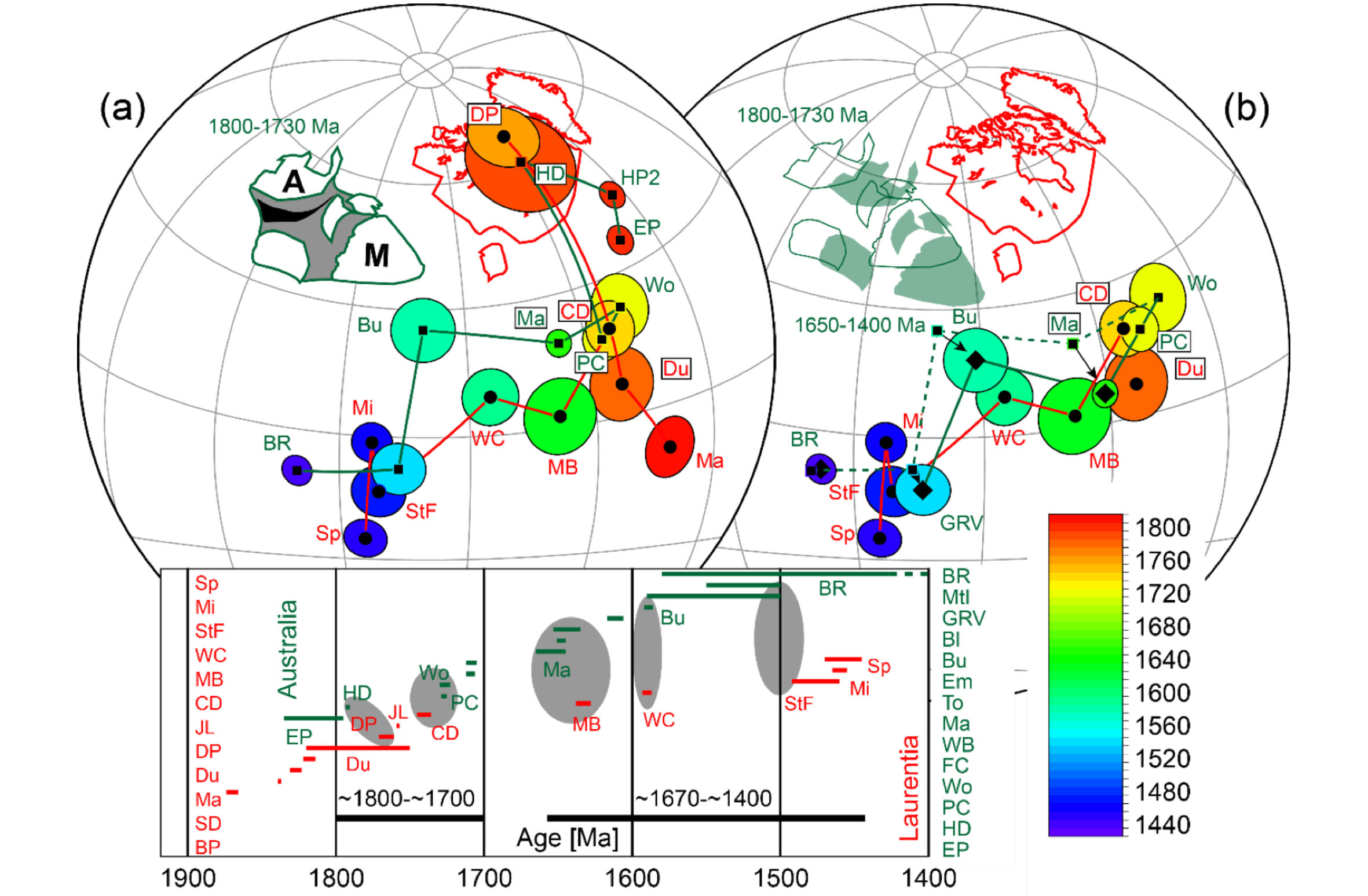
Figure 2. (a) Apparent polar wander paths of Australia (poles shown as squares and diamonds) and Laurentia (poles shown as black dots), colour coded with ages between 1900 and 1400 Ma after rotating proto-Australia to Laurentia to match their 1800-1730 apparent polar wander paths, or APWPs). (b) Proto- Australia rotated further to Laurentia, moving from the pre-1730 Ma position (green cratonic outlines) to its Nuna position after 1650 Ma (green shaded cratons), to match their APWPs for the1650-1400 Ma time interval, signalling the final assembly of the supercontinent Nuna soon after 1650 Ma.
This project is part of CCFS theme 2, Earth’s Evolution, and contributes to understanding Earth’s Architecture.
Contacts: Uwe Kirscher, Zheng-Xiang Li
Funded by: CCFS Flagship Program 5, ARC Laureate Fellowship to ZXL, ARC LIEF grant to establish the new palaeomagnetism laboratory at Curtin University
Riding high on new wave model for southern California
Southern California, on the Pacific-North America plate boundary, is a tectonically active region where geological terranes are merged by major tectonic events during the evolution of the plate boundary. A 200-300 km wide zone of transpressive deformation (Hauksson, 2000) results from this interaction. These tectonic events have produced the complex 3D crustal structure of southern California, including terranes such as the Peninsular Ranges, Salton Trough, Transverse Ranges and southern Sierra Nevada Range (Fig. 1). Tape et al. (2009, 2010) generated a new 3-D crustal model M16 by applying adjoint tomography to a dataset of waveforms recorded at 203 stations from 143 local earthquakes. Their inversion used frequency-dependent travel-time measurements of three-component body waves and surface waves filtered at periods in the band 2-30 s. In this study, we apply adjoint tomography to 5-50 s Rayleigh waves extracted from ambient noise to further improve the M16 model, especially in the lower crust. A spectral-element method was used to simulate wave propagation in M16 and successively updated the models.
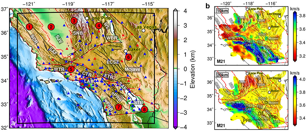
Figure 1. (a) Map of southern California with topography, bathymetry and active faults. The solid black outline defines the simulation region. The 148 stations used in this tomographic study are shown as triangles, out of which 19 are selected for the line search shown in red. Faults are indicated by bold black lines. Labels 1-8 denote eight geological provinces bounded by red dashed lines: 1. Coastal Ranges; 2. Great Central Valley; 3. Sierra Nevada; 4. Basin and Range; 5. Transverse Ranges; 6. Mojave Desert; 7. Peninsular Ranges; 8. Salton Trough. Geological features labeled in bold white letters as references for subsequent figures: SCR, southern Coast Range; SJV, San Joaquin Valley; SAF, San Andreas Fault; LAB: Los Angeles Basin; ePRB and wPRB: east and west Peninsular Ranges Batholith; SNB, Sierra Nevada Batholith; STB: Salton Trough Basin. (b) Horizontal slices of shear velocity for model M21 at 10 and 20 km.
The final model shows features generally in agreement with the initial model, especially at the shallowest depths (≤ 5 km). However, the new Vs model also reveals several new features in the mid-to-lower crust, including: (1) the mean speed of the lower crust is slowed down by about 6%; (2) high Vs anomalies (up to +4%) are observed throughout the crust in the Los Angeles Basin (LAB) and Central Transverse Ranges (CTR); (3) high Vs anomalies are observed in the lower crust beneath the westernmost Peninsular Range Batholith and Sierra Nevada Batholith; (4) an enhanced shallow high-velocity zone in the mid- crust is observed beneath Salton Trough Basin (STB). Our model also shows a refined lateral velocity gradient across PRB-SNB- SAF which provides constraints on the west-east compositional boundary of PRB-SNB, as well as the dip angle and the depth extent of SAF. As ambient noise cross-correlations are available between all station pairs, the new tomographic model we have obtained shows a better resolution than the initial one in areas not well-covered by event-station paths. Owing to the long- period features of ambient noise, the lower crust is much better illuminated through gradual fitting of long-period signals. The total misfit reduction, model validation from earthquake data, and a series of point-source resolution tests all confirm the robustness of our new tomographic model.
We compared the initial model M16 and our final model M21 to two other models: one is Barak2015 from traditional ambient- noise tomography, and the other is CVM-S4.26 from a full waveform inversion of earthquake and ambient noise data. In general, the CVM-S.4.26 model contains more small-scale features than the other three models and has much higher velocities, perhaps due to the larger number of data used and iterations performed. Based on similar initial models and data sets, our final model shows velocity variations that are generally in agreement with those of Barak2015. However, our final model also differs from Barak2015 in several aspects, as shown in Figure 2. At the central section of SAF (profiles DD’), we observe a high- velocity zone in the middle crust that shows a slight NE dip, while Barak2015 shows it dipping into the lower crust. The high- velocity region in the lower crust beneath wPRB of our model is not as evident as that shown in Barak2015 and is only observed in the westernmost part (profile PRaa’). Our model shows that the southern boundaries of wPRB and ePRB have vertical-to- steep NE dips into lower crust, while Barak2015 shows only a slight NE dip in the middle crust (PRbb’). Moreover, our model shows increased shear velocities beneath LAB and CTR which are not identified in Barak2015.
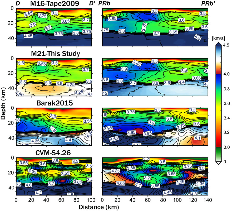
Figure 2. Comparison of model M16, M21, Barak2015 and CVM-S4.26 along DD’ profile across SAF and PRbb’ profile across PRB.
Our study demonstrates the feasibility of applying adjoint tomography to ambient-noise data in southern California, which is complementary in coverage to the earthquake data used in previous studies. The numerical spectral-element solver used in adjoint tomography provides accurate structure sensitivity kernels through 3D model iterations, and hence generates more robust images than those produced by traditional ambient-noise tomography based on analytical methods.
This project is part of CCFS theme 3, Earth Today, and contributes to understanding Earth’s Architecture.
Contacts: Kai Wang, Yingjie Yang
Funded by: IMQRE 43887678, DP120102372, DP120103673
Mapping the basaltic underplate: plume-related zircons from Mt Carmel
Xenocrystic zircons from Cretaceous pyroclastic vents on Mt Carmel, N. Israel, document three major periods of earlier mafic magmatism: Permo-Triassic (285-250 Ma), Triassic (250-220 Ma) and Jurassic (210-160 Ma), which are only poorly represented in the local crustal record. Related alluvial deposits also contain these zircon populations, but most alluvial zircons are Cretaceous (118-80 Ma), or derived from much younger volcanic episodes (age peaks at 30, 13, 11, 9-10 and 4 Ma) (Fig. 1a, b). The Permo- Triassic-Jurassic zircons are typically large and glassy; they have irregular shapes and a wide variety of internal zoning patterns (Fig. 2). They appear to have grown from melts in the interstitial spaces of coarse-grained rocks (cumulates, peridotites); many show evidence of recrystallisation, including brecciation and rehealing by chemically similar zircon. Igneous-looking grains have mantle- like δ18O (5.5±1 ‰), but recrystallisation leads to lower values (down to 3.1‰). Hf-isotope compositions lie midway between the CHUR and Depleted Mantle (DM) reservoirs; Hf model ages suggest that the source region separated from DM in Neoproterozoic time (1000-1500 Ma). Most Cretaceous zircons have 176Hf/177Hf similar to those of the older zircons, suggesting they recrystallised in the Cretaceous thermal event. Calculated melts in equilibrium with the Permian to Cretaceous zircons are depleted in LREE and P, and have large positive Ce anomalies and negative Eu anomalies, variable Ti anomalies, and high and variable Nb, Ta, Th and U, consistent with the fractionation of monazite, zircon, apatite and Ti-bearing phases from the host magma. We suggest that these coarse-grained zircons crystallised from late differentiates of basaltic magmas, ponded near the crust-mantle boundary (ca 30 km depth), and were reworked repeatedly by successively younger igneous/ metasomatic fluids.
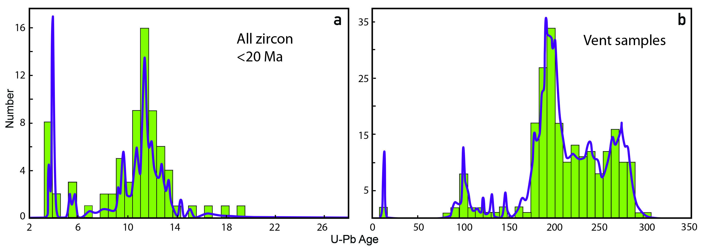
Figure 1. Age histogram/ cumulative probability curve for U-Pb data of a) Alluvial samples (0-20 Ma) and b) Vent samples (0-350 Ma).
The distribution of zircon populations in the Cretaceous volcanoes can be used to map the buildup of this basaltic underplate (Fig. 3). The Permian-Triassic (280-220 Ma) zircons are most abundant in the main central vents (Rakefet, Bat Shelomo, Makura) and the Ein Hashofet centre in the Ramot Menashe syncline. The Triassic-Jurassic zircons are found mixed with Permian-Triassic ones in Ein Hashofet and Rakefet, but make up the bulk of the sample in the northern bodies (BO, KM, and HA); the younger zircons are found mainly in KM, TAV and MH on the western side of Mt Carmel. This pattern suggests that the Permo-Triassic magmatism built up a ‘pillow’ beneath the core of the Mt Carmel-Menashe area, so that the magmas of the younger episodes tended to intrude toward the margins of this central area (Fig. 4).
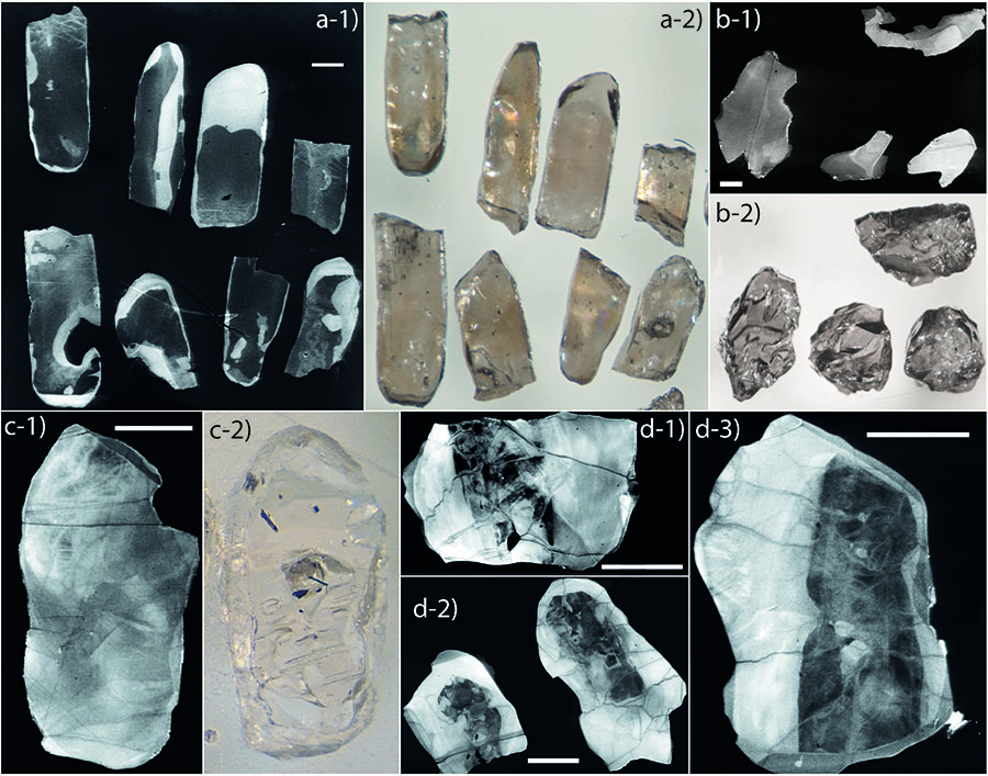
Figure 2. Images of Mount Carmel zircons. Scale bars are 200 microns. a. optical-microscope and cathodoluminescence 838 (CL) images of zircons showing corroded-prismatic shapes and core-rim zoning. b. Typical Mt Carmel-type zircons illustrating irregular shapes and internal structures. c. optical and CL images of large Mt Carmel- type zircon showing irregular form and internal brecciation. d. CL images of zoned Mt Carmel-type zircons, with brecciation.
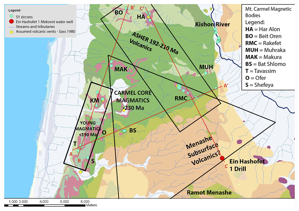
Figure 3. Map showing the distribution of zircon age populations in vents. Lines A-A’, B-B’, C-C’ mark corresponding sections 1-3 in Figure 4.
The trace element patterns of the Permo-Jurassic resemble those of zircons that crystallised from plume-related magmas (Iceland, Hawaii), and this is consistent with the compositions of Permian to Miocene basalts in the region. The zircon data support a published model that locates a fossil Neoproterozoic plume head beneath much of the Arabia-Levant region, which has been intermittently remelted to generate the volcanic rocks. The Cretaceous magmas carry mantle xenoliths derived from up to 90 km deep, providing a minimum depth for the possible plume head. Post-Cretaceous magmatism, as recorded in detrital zircons from the area, shows distinct peaks at 30 Ma, 13 Ma, 11.4±0.1 Ma (a major peak; n=15), 9-10 Ma and 4 Ma, representing the Lower and Cover Basalts in the area. Some of these younger magmas tapped the same mantle source as the Permian-Jurassic magmatism, but many young zircons have Hf- isotope compositions extending up to DM values, suggesting derivation of magmas from deeper, more juvenile sources.
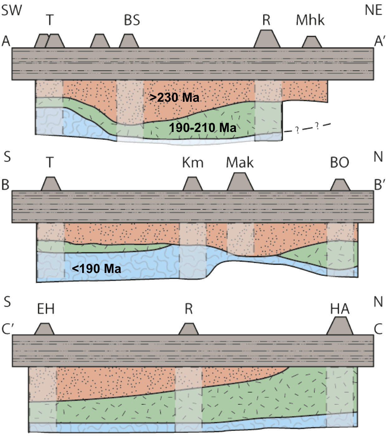
Figure 4. Cartoon showing the relative abundance of three zircon age populations in different vents, to illustrate the general structure of the gabbroic underplate at the crust-mantle boundary beneath the Mt Carmel area. Not to scale.
This project is part of CCFS theme 2, Earth’s Evolution, and contributes to understanding Earth’s Architecture and Fluid Fluxes
Contacts: Bill Griffin
Funded by: CCFS Flagship Program 1
Seismic image of the Capricorn Orogen – revealing the crustal component
The Capricorn Orogen records the Paleoproterozoic amalgamation of the Archean Pilbara and Yilgarn cratons to form the Western Australian Craton. Regional surveys involving geological mapping, geochemistry, and geophysics reveal a prolonged tectonic history of craton assembly and subsequent intracratonic reworking, which has significantly re-shaped the orogenic crust.
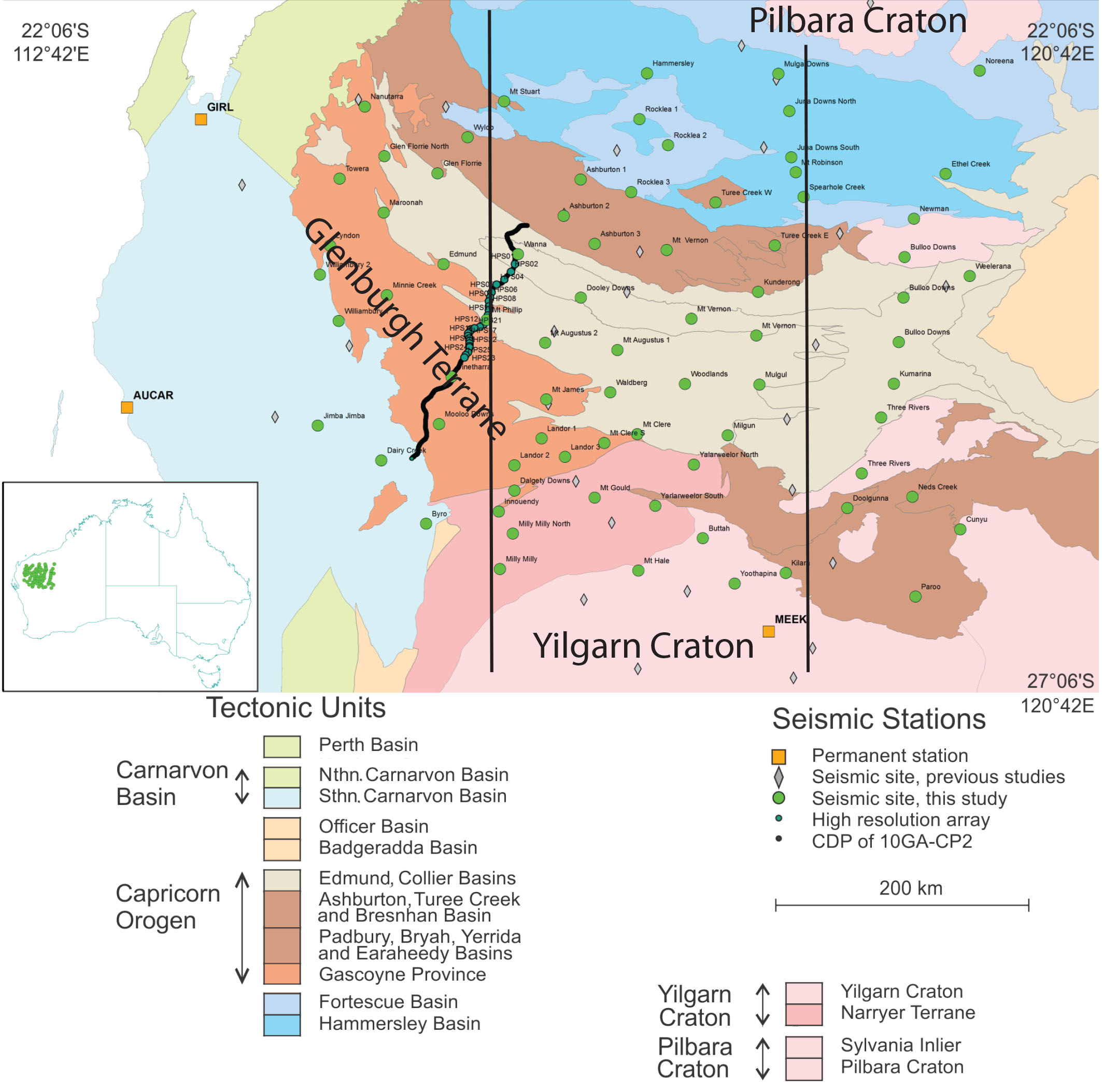
Figure 1. Capricorn seismic deployments and tectonic units. Green dots in the left panel are the 76 COPA stations from March 2014 to Nov 2017. Black line indicates the location of the 2010 active-source reflection line.
To better understand the tectonic history, we targeted the seismic structure of the orogenic crust and sub-crustal lithosphere. We deployed a 76-station broadband array (COPA, Capricorn Orogen Passive-source Array) that covers the orogen in a 2D grid over nearly 500 km by 500 km surface area with roughly 40 km station spacing. The planned 36-month deployment could guarantee enough data recordings for 3D structure imaging using body wave tomography, ambient noise surface wave tomography and P- and S-wave receiver function Common Conversion Point (CCP) stacking techniques. Upon a successive instrument loan of 36 sets of seismometers from the ANSIR national instrument pool, 34 broadband seismometers (2 as backup) were first deployed in the western half of the orogen. In late 2015/early 2016, most stations were rolled over to the eastern half.
Here we report preliminary results from ambient noise tomography that focuses on the shear-wave velocity structure of the orogenic crust (Fig. 2). Some interesting results are noted.
1. Significant velocity differences are found between the western and eastern parts of the orogen;
2. The Glenburgh Terrane has slow velocities in the mid- to lower crust, similar to the bounding Pilbara and Yilgarn cratons.
3. Clear Terrane boundaries may be marked by fast velocity lower crust that may represent mafic underplating associated with the 2.2 Ophthalmian and 2.0 Glenburgh Orogenies. These might represent the deep crustal sources of the mineral deposits (gold mines indicated in Fig. 2).
Combining our earlier crustal results (see, 2016 Research highlight “An Archean microcontinent lurking in the Capricorn Orogen”), we can draw broader conclusions.
• Seismic signatures are found in the crust for the paleo- subduction associated with the 2.2 Ga Ophthalmian Orogeny, although there is no associated magmatic evidence at the surface.
• The Glenburgh microcontinent shares some crustal signatures (slow velocity, felsic composition, resistive crust) found in other Archean cratons, suggesting its formation may be associated with Archean vertical plume accretion.
• Significant reworking of the terrane crust left marks along the margins (lower crustal underplate, tectonic wedges), and inside the terrane (the fast-velocity upper crustal layer).
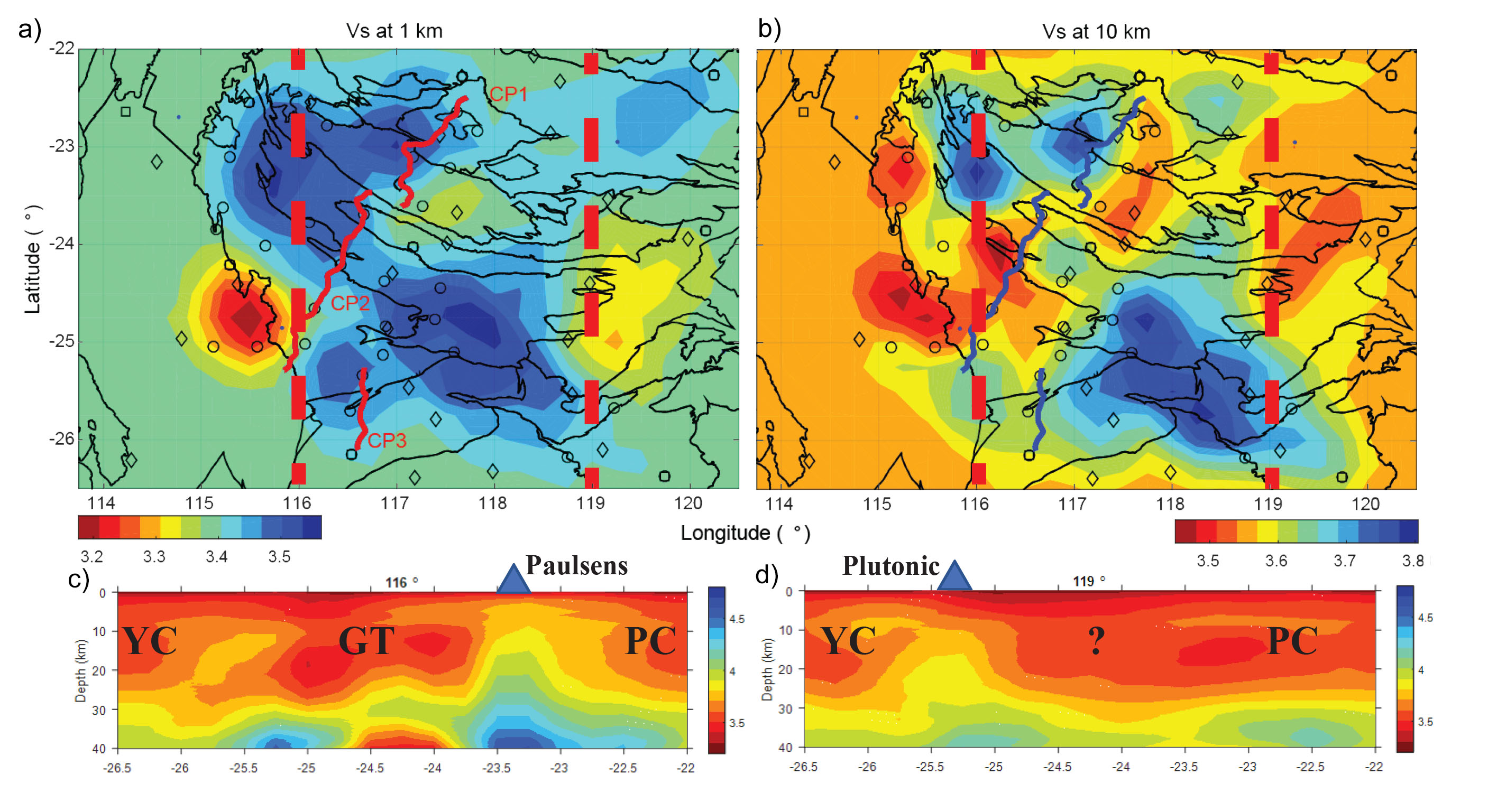
Figure 2. Initial ambient-noise tomography results for the orogen-scale COPA array. a) Vs at 1 km depth. b) Vs at 10 km depth. Stations used in the study are shown as open circles (deployed in this study) and open diamonds (early temporary deployments and permanent sites in the region). c) a cross-section for the western part of the orogen along 116° Longitude. d) a cross-section of the eastern part of the orogen along 119° Latitude. YC, Yilgarn Craton; GT, Glenburgh Terrane; PC, Pilbara Craton. The question mark indicates the region currently lacking station coverage. Blue triangles show the approximate locations of the Paulsens and Plutonic gold mines.
This project is part of CCFS themes 1, 2 and 3, Early Earth, Earth’s Evolution and Earth Today, and contributes to understanding Earth’s Architecture.
Contacts: Huaiyu Yuan, Klaus Gessner
Funded by: CCFS Flagship Program 7
Sulfidised stromatolites from the Pilbara: A new benchmark for oldest life on Earth
Definitive benchmarks for evidence of the oldest life on Earth remain controversial. Over the past decades, one has been the ~3.46 Ga Apex chert microfossil locality in the East Pilbara Terrane of Western Australia, but recent studies have convincingly shown that the filamentous structures in those cherts are abiotic artifacts rather than true microfossils. Claims for even older microfossil remains from Quebec, Canada, around 3.8 Ga, are even more contentious because they are less well-preserved in strongly metamorphosed rocks, and are not evidently composed of biological matter. Putative remains of microbial communities, generally known as stromatolites, have been reported from ~3.7 Ga old rocks of Greenland. However, stromatolite morphology – though compelling for most – remains contentious in the absence of microfossils, convincing biomineralisation, or chemical-based evidence. Here we report unequivocal microbial remains preserved in biologically precipitated stromatolitic sulfide (pyrite ± sphalerite, millerite and galena) laminae from the ~3.48 Ga old Dresser Formation, Pilbara Terrane, Western Australia.
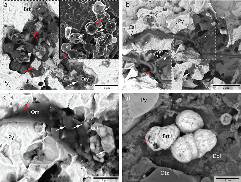
Figure 1. Backscattered electron- (BSE-) and secondary electron- (SE-) images of biomorphs rich in organic matter and barite mineralisation in stromatolitic sulfide laminae, observed following nitric acid etching. a. Irregularly-structured organic matter (white arrow), along with coccus-like hollow spheres and bulbous sheaths containing relict nanoporous pyrite cores (red arrow). The subfigure outlines the chain-like arrangement of coccus-like spheres and smaller irregular particles of organic matter (dashed lines), menisci of structureless organic matter (red arrows) interpreted as mineralised extracellular polymeric substance (EPS), as well as divided and bulbous arrangements of connected sphere (white arrows) suggestive of cell division (i.e., binary fission). b. Putative mineralised biofilm represented by a rope-like twisted and branched (red arrow) filament bundle speckled with quartz, calcite, and barite. c. Strand (white arrow) rich in organic matter yielding partly carbonatised (calcite) submicron-sized spheroids of organic matter (white arrows) occurring side by side with euhedral platy hexagonal calcite, replicating biofilm carbonatisation involving fossilisation of cocci bacteria. d. Agglomeration of submicron-scale barite spherulites in heavily etched dolomite. These barite textures are known from modern-day marine bioaccumulations, and have been replicated many times in laboratory experiments employing living strains of modern sulfur- oxidising marine bacteria. Brt = barite; Cal = calcite; Dol = dolomite; Om = organic matter; Py =Pyrite; Qtz = quartz.
Although prone to recrystallisation and multiple stages of sulfide overgrowth, they preserve early- stage framboidal pyrite in nanoporous pyrite rich in organic matter, replicating textures known from in situ sulfidisation of modern biofilms. Furthermore, we report candidate microfossils represented by spheres of organic matter that resemble coccus bacteria (Fig. 1a), as well as strands and filaments (Figs. 1b, c) interpreted as mineralised biofilms. Supporting evidence for a biological origin is derived from micromineralogy including spherulitic barite biomineralisation (Fig. 1d), as well as Micro-Raman Spectroscopy (MRS) analysis of organic matter (Fig. 2a) combined with Nanoscale Secondary Ion Mass Spectrometry (NanoSIMS) isotope mapping of elements necessary for life (carbon, nitrogen and oxygen; Fig. 2b, c). Collectively, the remarkable range of textural, mineralogical, and chemical biomarkers provides new definitive evidence of the oldest life on Earth at ~3.48 Ga, and points to a new taphonomy involving microbial sulfidisation that is important not only in the search for ancient life on Earth, but elsewhere in the solar system.
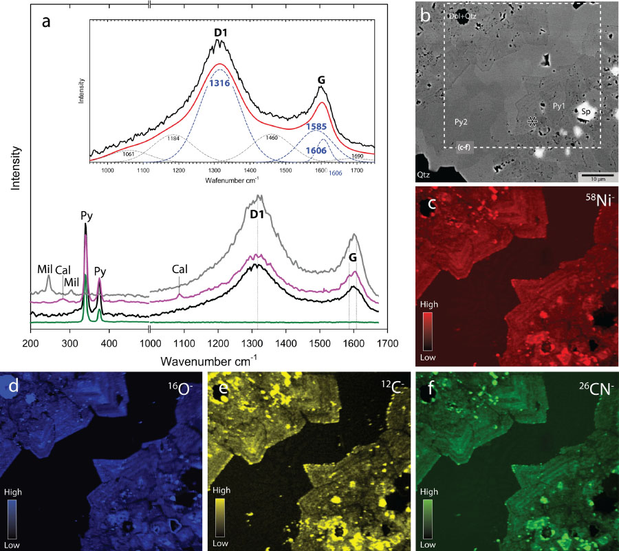
Figure 2. Molecular and isotopic analysis of organic-matter-rich sulfide (pyrite ± millerite) assemblages in stromatolitic sulfide laminae. a. Micro-Raman Spectroscopy (MRS) analyses of organic-matter-rich nanoporous pyrite and millerite compared with barren nonporous pyrite. Spectral deconvolution in the 900-1700 Δcm-1 range (subfigure) illustrates the immature kerogen- like nature of organic matter; i.e. predominance of molecular disorder (D1 band) relative to graphite-like order (G band). b-f. Backscattered electron (BSE-) image, and Nanoscale Secondary Ion Mass Spectrometry (NanoSIMS) maps of 51Ni-, 16O-, 12C-, and 26CN-, indicating coupled enrichments in nanoporous pyrite (Py1) relative to ubiquitous overgrowths of annealed nonporous pyrite (Py2). Cal = calcite; Dol = dolomite Mil = millerite; Py1 = nanoporous pyrite; Py2 = nonporous pyrite; Py = pyrite; Qtz = quartz; Sp = sphalerite.
This project is part of CCFS themes 1 and 2, Early Earth and Earth’s Evolution, and contributes to understanding Fluid Fluxes.
Contacts: Raphael Baumgartner, Martin Van Kranendonk, David Wacey, Marco Fiorentini, Stefano Caruso
Funded by: CCFS Flagship Program 4
Zircon morphology, isotopes and the magmatic fertility of porphyry Cu-Au deposits
Porphyry Cu-Au systems are associated with intrusive complexes made up of hydrous magmas related to continental and island arcs. These systems have a relatively well defined geodynamic framework. Increasing the understanding of the geologic processes and factors that lead to their formation will allow a better exploration success rate. Zircon compositions are powerful tools for unravelling the petrogenesis and magmatic evolution of Cu-ore- forming magmas. The Tampakan and Batu Hijau deposits (Fig. 1) are set in island-arc systems associated with subduction zones, and can be used to evaluate the importance of crustal contamination of the magmas.
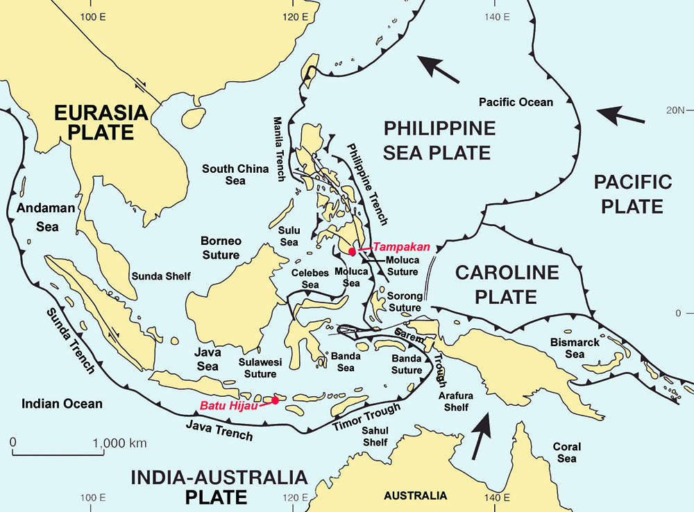
Figure 1. General plate boundaries across Indonesia, showing the most prominent trench and suture zones. Light grey shaded area represents the extension of the Sunda- Banda arc. Location of the Batu Hijau and Tampakan deposits represented by red dots. Modified after Metcalf (2009).
The Batu Hijau deposit sits along an arc system that has subducted older remnants of the Australian continental shelf (Figs. 1 and 3).
The Batu Hijau district (Fig. 1) contains 914 Mt of ore (0.53% Cu and 0.40 g/t Au). It is located on the island of Sumbawa along the Sunda-Banda volcanic arc segment between Wetar and Eastern Java. The arc consists of a succession of Miocene to Holocene units built over oceanic crust sitting close to the margin of the Sunda continental shelf. Parts of the Australian continental margin, with ages between ca 3200 and 500 Ma have been subducted along the arc, while parts of the fore-arc were dynamically uplifted.
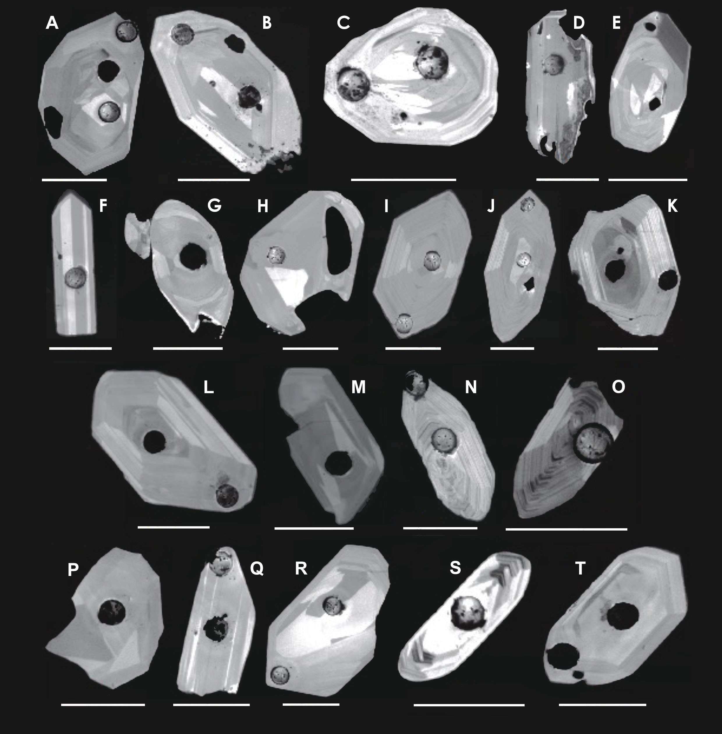
Figure 2. Morphologically, syn-ore zircons from the two studied deposits are characterised by unzoned cores surrounded by thin oscillatory zoned rims. Scale bars 100 μm.
The Tampakan district (Fig. 1) hosts giant high-sulfidation and porphyry Cu-Au deposits of Pliocene age, with estimated ore reserves of 12.5 million tonnes Cu and 500 tonnes Au. It lies at the northern end of the Mioceneto Pliocene Sangihe volcanic arc on Mindanao Island, between crustal remnants derived from the Australian and Euroasian continental plates. This is a syn- to post- collisional setting as the result of terrane accretion and arc collision. The geology of the region is dominated by a series of basalts and basaltic andesites of early to mid-Miocene age and related volcanoclastic sediments. The basaltic andesite unit is intercalated with a limestone unit. The package is unconformably overlain by the Tampakan Andesite Sequence. The Tampakan Andesite sequence represents an eroded stratovolcanic complex comprising 4 andesitic volcanic cycles lasting around 4.5 Myrs.
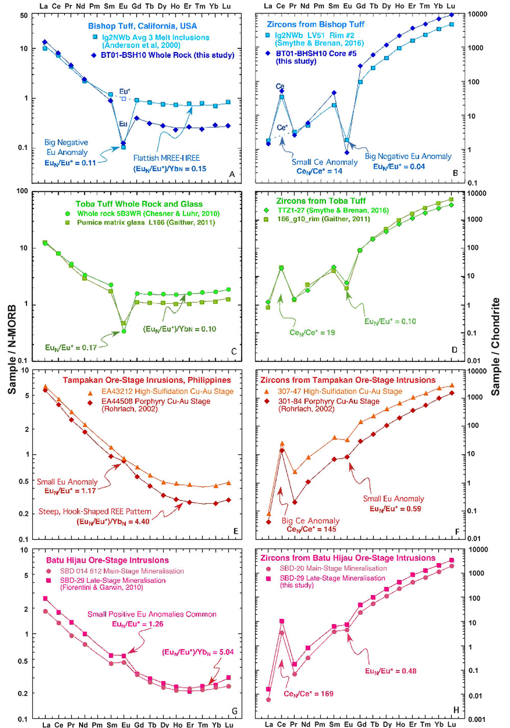
Figure 3. Whole rock (left) and zircon elemental data (right) display typical features of felsic arc magmas associated with magmatic- hydrothermal Cu ore deposits. These features include: steep, hook-shaped REE patterns, minimum around Er, and absence of a significant negative Eu anomaly.
Zircon textural characteristics (Fig. 2) reflect two stages of magma emplacement. Unzoned cores suggest crystallisation within a long-lived, deep, hot magma chamber while the thin zoned rims suggest a relatively short residence time in the shallow crust, which may have prevented the loss of Cu metals. Preliminary O-isotope analyses show no sign of crustal contamination. I have had to infer that preliminary results show that zircons from pre- and post-ore samples, although not mineralised, display the same characteristics as syn-ore samples. The fact that all samples display such characteristics suggests that factors other than magma fertility played an important role in leading to mineralisation.
This project is part of CCFS themes 2 and 3 and Earth’s Evolution and Earth Today, and contributes to understanding Earth’s Architecture and Fluid Fluxes.
Contacts: Luis Parra-Avila, Bob Loucks, Marco Fiorentini, Yongjun Lu
Funded by: GSWA
Porphyry Cu fertility in the Tibetan Plateau
Cenozoic porphyry Cu deposits in the Tibetan Plateau are typical of porphyry systems developed in continental collision zones. Understanding the temporal and spatial distribution of these deposits will help unravel the genesis of porphyry deposits in collision zones in general, and exploration targeting of porphyry deposits in similar orogenic belts.
Figure 1. Contour map of zircon two-stage depleted mantle model ages (TDMc) for granitoid and felsic volcanic rocks in the Tibetan Plateau.
Results of zircon Lu-Hf isotopic mapping using 652 zircon samples from the Tibetan Plateau are shown in Figure 1. They demonstrate that most porphyry Cu deposits are associated with isotopically juvenile domains along the terrane-bounding Indus- Yarlung and Jinsha suture zones (Fig. 1). Such isotopic mapping can narrow the search space from over 2500 km scale to ~500 km scale.
Whole-rock geochemical mapping using ca 1200 samples across the Lhasa Terrane shows that all porphyry Cu deposits occur in domains of high 10000*(Eu/Eu*)/Y (>800; Fig. 2). Thus, the (Eu/Eu*)/Y ratio is the best whole-rock fertility indicator, and is interpreted to indicate extremely high magmatic water contents which induce early and prolific fractionation of hornblende and suppress early plagioclase crystallisation.
Figure 2. Contour map of whole-rock geochemical ratio of 10000*(Eu/Eu*)/Y for mafic to felsic intrusive and volcanic rocks in the Lhasa Terrane, southern Tibet.
Zircon U-Pb and trace-element data were obtained from 66 igneous samples of Jurassic to Miocene age (181-11 Ma) in the eastern Gangdese belt. Both xenocrystic and magmatic zircons show systematic compositional evolution from Jurassic to Miocene. From ca 200 Ma to ca 55 Ma, zircon Eu/Eu* (0.1-0.4), 10000*(Eu/Eu*)/Y (0.1-10), and (Ce/Nd)/Y (0.001-0.05) ratios remain broadly similar. However, these zircon trace-element ratios increase rapidly after ca 55 Ma and peak at ca 13 Ma with Eu/Eu*, 10000*(Eu/Eu*)/Y, and (Ce/ Nd)/Y up to 1, 70, and 2, respectively (Fig. 3). Similar temporal trends are also observed for whole-rock Sr/Y, La/ Yb, and (Eu/Eu*)/Y, although whole- rock Eu/Eu* ratios appear to be similar throughout the Jurassic-Miocene period. In addition, Cretaceous samples show juvenile Hf-O isotopic signatures, whereas Eocene-Miocene intrusions show increasing zircon δ18O values and decreasing epsilon Hf values, suggesting that increasing amounts of supracrustal materials were involved in magma genesis after c. 55 Ma.
Exploration is a scale-reduction process. Zircon Lu–Hf isotopic mapping is powerful in identifying juvenile crustal domains which are more prospective for porphyry Cu deposits. The combined mapping of zircon Hf isotopes and whole-rock 10 000*(Eu/Eu*)/Y ratio can help focus exploration on prospective areas.
Figure 3. Zircon 10000* (Eu/Eu*)/Y ratio vs Age (Ma) for 66 magmatic rocks in the eastern Gangdese belt, Lhasa Terrane, southern Tibet.
This project is part of CCFS themes 2 and 3 and Earth’s Evolution and Earth Today, and contributes to understanding Earth’s Architecture.
Contacts: Yongjun Lu, Zeng-Qian Hou, Zhi-Ming Yang, Luis Parra-Avila, Marco Fiorentini, Cam McCuaig, Bob Loucks
Funded by: CCFS Flagship Program 2
Following the tracks of carbon in the upper mantle
The mantle carbon cycle is an important, but largely unconstrained and debated problem in the deep Earth volatile cycle. The uncertainty derives from two main causes:
1) The location and conditions of carbonate melting in subduction slabs, along with the physical mechanisms by which carbon is removed from the slab into the overlying mantle wedge;
2) release of CO2 from the downgoing slab causes changes in the chemical and physical properties of the lithospheric mantle by metasomatic interaction.
To better constrain these processes we have undertaken theoretical modelling to couple decarbonation reactions and experimentally-produced melting curves for carbonated basalts (MORB + CO2) and sediments at pressures and temperatures relevant to upper mantle conditions.
The results confirm the hypothesis that carbon probably is likely filtered out at uppermost mantle conditions, suggesting a carbon increase in the lithospheric mantle over time. Carbonate melting in the mantle transition zone may provide an important component for organic-carbon signatures in diamonds. Lithospheric mantle enriched in CO2 can be reactivated in subsequent tectonic events and lead to massive CO2 release far from its original source – the subduction zone.
Figure 1. Model evolution for the initiation of carbonated silicate melts within a subarc region within the phase topology of a carbonated silicate melt: a) Model domain and evolution at 19.09 Ma. b) Enlarged area of carbonated silicate melting. c) CO2 [wt. %] in rocks determined as stable by thermodynamic modelling. d) Devolatilised fluids at depth determined as unstable from thermodynamic modelling. e) Selected P-T paths of basalts and sediments crossing solidi determined by petrological experiments.
Overall, this study, though just beginning, is contributing to better understanding the deep carbon cycle and our ability to quantify the amount of CO2 stored in the mantle.
This project is part of CCFS themes 2 and 3 and Earth’s Evolution and Earth Today, and contributes to understanding Earth’s Architecture and Fluid Fluxes.
Contacts: Weronika Gorczyk, Christopher Gonzalez
Funded by: CCFS Flagship Program 2
CO2 released in continental rifts is “fried lithospheric diamonds”
Continental rifts around the world are characterised by a strong accumulation of carbonate-rich volcanoes, including carbonatites and ultramafic alkaline rocks. These rocks store enormous quantities of carbon that appears to have its source in the lower parts of the continental lithosphere. These rocks are well known for extremely runny and fast-flowing lavas at Oldoinyo Lengai in northern Tanzania, but are also important as the best examples of primary melts of the mantle from the lower cratonic lithosphere at depths of 120-180 km (known as ultramafic lamprophyres).
Studies of the release of CO2 gas from continental rifts are being undertaken to assess the natural release of CO2 into the atmosphere over time in order to compare and contrast it to levels of anthropogenic (man-made) carbon dioxide, which is accepted as being principally responsible for climate change. Measurements of CO2 release have shown that even more carbon dioxide is released along rift faults and from volcanoes during their quiescent periods than volcanoes during eruptions.
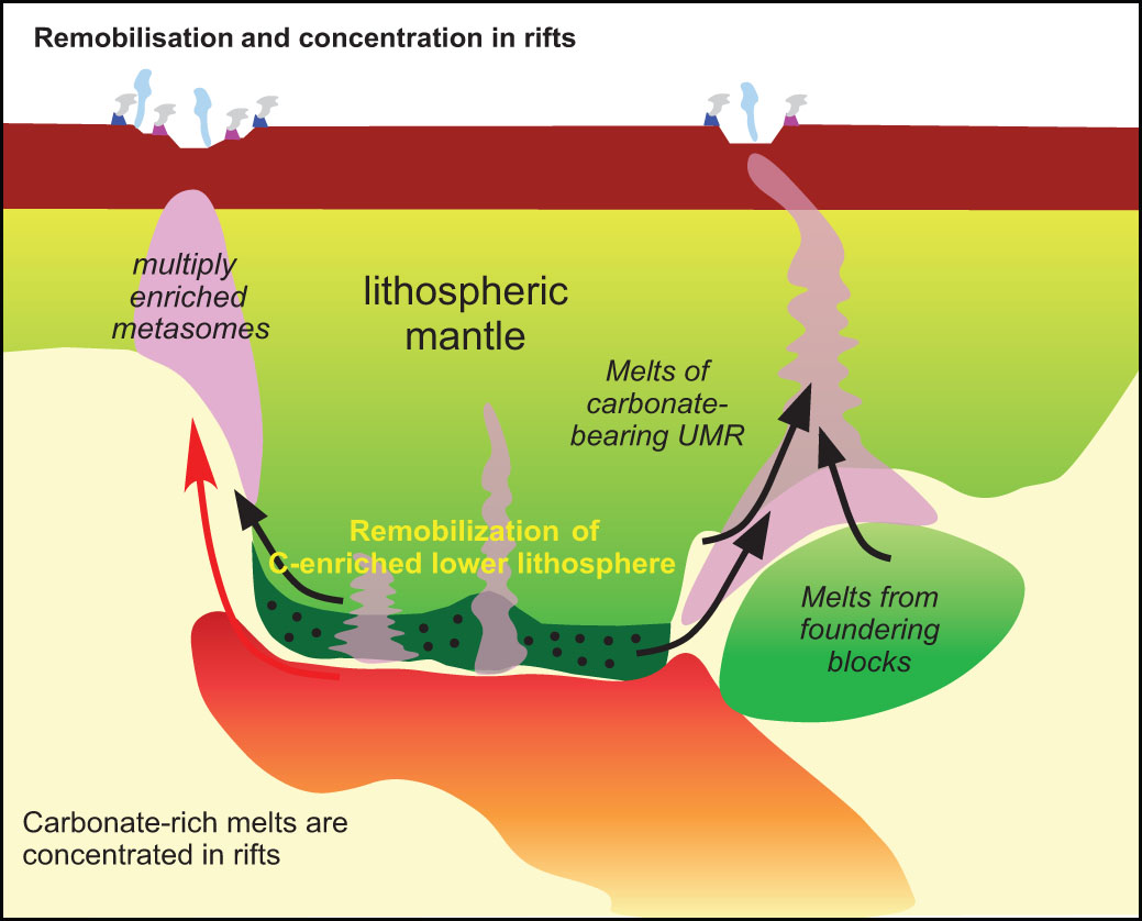
Figure 1. Stored carbon is reactivated by partial melting, concentrating the carbon in zones (purple; 150–240 Mt C km–3) above which rifts may develop. Carbon escapes any foundering blocks, adding to the concentration in the sub-rift zones. Rift degassing thus involves carbon reactivated from an initially large volume. UMR, ultramafic rocks.
Our interdisciplinary study brings together experts on degassing in continental rifts (Tobi Fischer of the University of New Mexico) and melting of the mantle (Stephen Foley, CCFS) in an attempt to understand where the carbon comes from, and whether we can explain how the concentration in continental rifts occurs. The result, published in Nature Geoscience in December 2017 (CCFS Publication #995 Foley & Fischer, 2017, Nature Geoscience, 10, 897-902), match the measured output of CO2 gas in continental rifts to its capture, storage and remobilisation at the lithosphere base (150-200 km) within a factor of two – an excellent agreement in view of the great uncertainties involved.
The trapping and storage of carbon in the lower lithosphere was modelled as a three-stage process: (1) the original formation and stabilisation of the cratonic lithosphere, (2) gradual degassing from the mantle over time, and (3) carbon acquired from the passage of mantle plumes that contain carbon recycled into the mantle at subduction zones. When continental rifts form, this carbon, which has been stored for up to 3 billion years in the lithosphere, is remobilised by melting and focused into restricted zones beneath rifts, where deep fracture zones facilitate its concentration (Fig. 1).
Our calculations showed that the first step – the formation of the lithosphere itself – is insignificant in the deep carbon budget. The gradual degassing and release from mantle plumes were found to be similar in importance, with the latter slightly outweighing the former. To assess gradual degassing, we used similar models to those used for degassing at mid-ocean ridges, but modifying them for the depth zone relevant to sub-cratonic areas. Degassing from mantle plumes has been calculated before, because of the suspicion that mantle plumes may have caused the mass extinction of 96% of species at the end of the Permian. Here again, we used similar models, but modified the details for the pressure-temperature conditions and age ranges relevant to cratons.
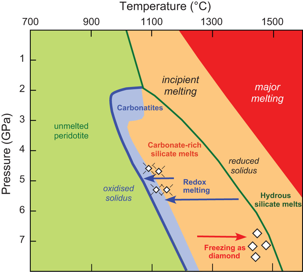
Figure 2. Melting curves of peridotite in reduced (green line) and oxidised (blue line) conditions in the incipient melting regime (blue to brown background). Carbon is immobilised in the reduced lower lithosphere by freezing to form diamond (red arrow) due to the change from blue to green melting curve. Later rifting and mantle upwelling causes access of oxidised melts to stored reduced carbon, depressing the solidus (redox melting; green line to blue line; blue arrows). Blue area indicates carbonatitic melts.
The entrapment and release of carbon in the lower lithosphere is controlled largely by redox processes: carbonate-bearing melts freeze in the lithosphere because the environment there is more reduced, so that the carbon is stored as diamonds. Conversely, when melting occurs, the diamonds are oxidised and dissolve in the melts as carbonate (Fig. 2), enabling its transport and focusing into the zones beneath the rifts.
The values estimated for CO2 release in rifts are 19 megatons of carbon per year (Mt/yr), and for time-integrated input into the lithosphere and focusing beneath rifts around 30 Mt/yr, just 50% higher. These values are closer than appears when one considers that much carbonate is not released into the atmosphere, but remains in igneous rocks near the surface.
However, this is a generalised model based on today’s degassing pattern. At times in the past when supercontinents were breaking up, the total length of rifts was probably 3-5 times that on the Earth today. In these times, the amount of CO2 released must have been correspondingly higher, so that natural CO2 release may have directly affected the atmosphere to warm the climate.
This project is part of CCFS themes 2 and 3, Earth’s Evolution and Earth Today, and contributes to understanding Earth’s Architecture and Fluid Fluxes.
Contacts: Stephen Foley
Funded by: CCFS Flagship Program 3, USA National Science Foundation Grant EAR-11130660
Tiny droplets betray mantle melt origins
Melts in the upper mantle are commonly responsible for metasomatic reactions, which change the mineral and geochemical composition of the peridotite wall-rock. In most cases, the presence of an infiltrating melt is only evidenced by these characteristic compositional features in mantle rocks. However, on rare occasions, the melt can be ‘caught in the act’ when trapped as primary silicate melt inclusions in newly- forming crystals.
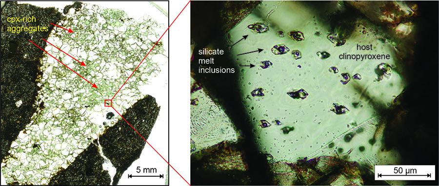
Figure 1. Left: clinopyroxene-rich, metasomatically altered xenolith. Right: merged image of plane- polarised photos, taken at different foci, of a clinopyroxene grain with primary silicate melt inclusions.
Such an example was investigated in a metasomatically altered upper-mantle xenolith from the Nógrád-Gömör Volcanic Field, northern Pannonian Basin (Central Europe). Xenoliths from this locality have recently been shown to be affected by multiple metasomatic events (see CCFS publication #1004) the latest of which was caused by an intraplate mafic melt, resulting in clinopyroxene enrichment and elevated Fe contents. These metasomatic clinopyroxenes frequently host primary silicate melt inclusions (Fig. 1), which are about 10-20 μm in diameter and are partially crystallised, with several daughter minerals, residual glass and a gas bubble. The mineralogical, major- and trace-element compositions of several silicate melt inclusions were analysed to constrain the composition of the trapped melt.
We have used Raman spectroscopy to identify the daughter minerals, compromising clinopyroxene, apatite, anhydrite, barite, amphibole and mica. The gas bubbles are dominantly composed of CO2. Subsequently, silicate melt inclusions were analysed by focused ion beam coupled scanning electron microscopy (FIB-SEM), a novel technique in nanoscale geological studies. The technique involves using the ion beam to slice through a small sample volume containing an inclusion, saving an image of each slice and carrying out in situ geochemical analyses on the exposed phases of the silicate melt inclusion (Fig. 2). Additional daughter phases were identified (spinel, sulfide) by this technique, and a 3D phase map was constructed for the silicate melt inclusions, allowing calculations of the bulk modal and major-element compositions. Trace-element compositions then were determined using laser-ablation inductively coupled plasma mass spectrometry.
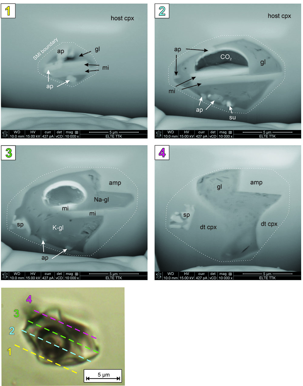
Figure 2. Plane-polarised light photomicrograph of a silicate melt inclusion and backscattered-electron images at different stages of the slicing process. Abbreviations of daughter phases: cpx – clinopyroxene, amp – amphibole, mi – mica, ap – apatite, sp – spinel, su – sulfide, gl – glass.
Bulk compositions lie within a narrow range for all the analysed silicate melt inclusions, indicating that they have trapped the same melt in similar conditions. This melt appears to be mafic in composition, with an enrichment in the most incompatible trace elements, like the host alkali basalt (Fig. 3). However, their high Fe contents verify that the trapped melt is the one linked to the latest metasomatic event in the studied locality. A simple geochemical model of Zajacz et al. (2007, J. Petrology) was applied, using the relationship of Nb and Y, to constrain the genesis of this melt (Fig. 3). The concentration of Y is commonly regarded as an indicator for the presence of garnet in the source, whereas Nb can be used to calculate the degree of partial melting. Based on the results, the metasomatising melt was generated by low-degree (~ 2%) partial melting of a garnet lherzolite, with slightly different composition than the source of the host magma.
Several post-entrapment processes can be reconstructed from the appearance and composition of the silicate melt inclusion daughter phases. The low density of the CO2 bubble indicates that it was exsolved from the residual glass at shallow depths, most likely during ascent to the surface. Subsequently, secondary daughter minerals (sulfates, mica) crystallised on the boundary between the bubble and the glass, indicating the previous presence of S and H2O in the volatile phase. Chemical heterogeneity in the glass may indicate a lack of equilibration before the ‘freezing’ of the system under surface conditions.
This project is part of CCFS theme 2, Earth’s Evolution and contributes to understanding Earth’s Architecture and Fluid Fluxes.
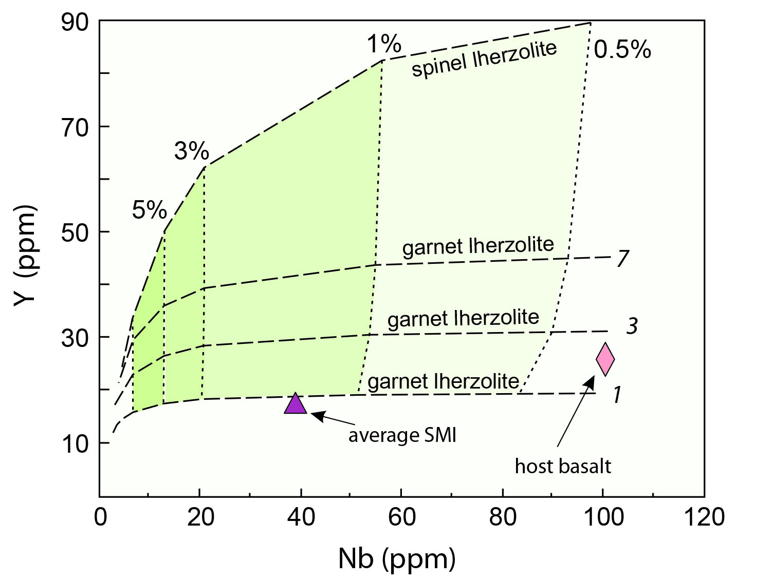
Figure 3. Nb vs Y diagram modelling the source composition and degree of partial melting for the genesis of the metasomatising melt. Dashed lines represent primitive mantle spinel- and garnet-lherzolite compositions; italic numbers refer to the clinopyroxene/garnet ratio in the source region. Dotted lines represent the degree of partial melting expressed in percentage.
Contacts: Nora Liptai, Sue O’Reilly, Bill Griffin, Csaba Szabó, Márta Berkesi (Eötvös University, Budapest, Hungary)
Funded by: CCFS Flagship Program 1, iMQRES, EPS postgraduate funds. This project is part of a cotutelle PhD program between Macquarie University and Eötvös University in Budapest, Hungary.
Super-reducing conditions in a modern volcanic system: key to the redox evolution of cratonic lithosphere
Estimates of the oxygen fugacity (fO2) of the cratonic subcontinental lithospheric mantle (SCLM) range from above the quartz-fayalite-magnetite (QFM) buffer to just above the iron- wustite (IW) buffer, and generally decrease with depth. Several lines of evidence suggest that the fO2 of the sublithospheric mantle may be constrained by the IW buffer (the presence of metallic Fe), but there also is evidence that volumes of significantly lower fO2 must exist within the SCLM, and perhaps within the deeper mantle. The remarkable super-reduced conditions in an off-craton volcanic setting (Mt Carmel, Israel; (Griffin et al., Geology 2016; CCFS # 830) may provide a key to the evolution of the redox state of the cratonic SCLM through time.
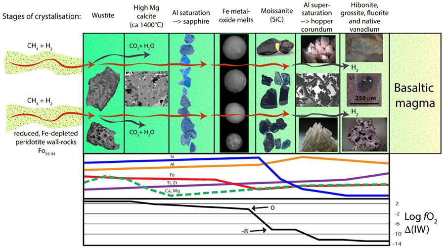
Figure 1. Model for the evolution of the Mt Carmel corundum-SiC system(s), as a progressive interaction between mantle-derived volatiles (CH4±H2) and a basaltic magma. The evolution of the melt composition and the fO2 of the system is illustrated schematically in the lower panels; the curves for elemental abundance are not to scale. The most important aspects are the drop in Fe (especially FeO) at the IW buffer, the rapid desilication of the melt following the onset of SiC crystallisation, and the extremely low fO2 required by the presence of abundant native V in the hibonite-grossite assemblage. The incongruent melting of anorthite suggests P ≥9 kb, while phase relationships in immiscible silicide melts indicate T = 1500-1200 °C. After Xiong et al., EJM 2017; CCFS#968).
Aggregates of hopper-formed crystals of Ti-rich corundum are abundant in Upper Cretaceous basaltic pyroclastic rocks (vent breccias, tuffs) exposed on Mt Carmel near Haifa, Israel. Melt pockets trapped within and between corundum crystals contain mineral assemblages (SiC (moissanite), TiC, Fe-Ti-Zr silicides/ phosphides and native V) that require P ≥ 1 GPa, T = 1500-1100 °C and extremely low fO2 (10 to 12 log units below IW). Mineral parageneses suggest that the corundum and the low-fO2 assemblages developed through interaction of basaltic magmas with mantle-derived (CH4+H2) at high fluid/melt ratios, leading to progressive lowering of fO2.
A schematic illustration of the process is shown in Figure 1; this model envisions a magma chamber being flushed by a steady supply of CH4±H2, but other configurations are possible. The material described here comes from at least 8 different volcanoes, with eruptions spread over ca 10 Ma, sampling similar magmatic systems erupted at different stages of their evolution, and has been used to reconstruct the evolution of a single synthetic system. The early oxidation of CH4 may have led to the precipitation of vesicular wustite (FeO) and abundant high-Mg calcite, found in the ejecta. The progressive lowering of fO2 to the IW buffer is marked by the appearance of a suite of mutually immiscible melts: native Fe, Fe-oxide/silicate melt and Ti-oxide/silicate melt, coexisting with the host CaO-Al2O3-SiO2 melt. This reaction appears to have removed most of the FeO from the system; none of the silicate phases in the trapped melts (see below) have significant contents of Fe. The removal of the Fe-FeO buffer would allow fO2 to decline (rapidly?) to the levels (6 to 8 log units below IW) where silicide melts would separate and SiC could precipitate. This would remove SiO2 from the melt (now dominated by CaO-Al2O3-MgO), driving it into Al2O3 –supersaturation which causes the rapid growth of corundum and the trapping of melt pockets. This desilication process apparently continued to near-completion, leading to a coarse- grained assemblage of hibonite (CaAl12O19) + grossite (CaAl4O7) + MgAl spinel + fluorite + native V, at fO2 ≤ 11 log units below IW. Many of the larger corundum aggregates are cut by breccia veins of amorphous (commonly vesicular) carbon, which also occurs in parallel-sided veinlets down to the sub-micron (TEM) scale, emphasising the important role of carbon in the evolution of these systems.
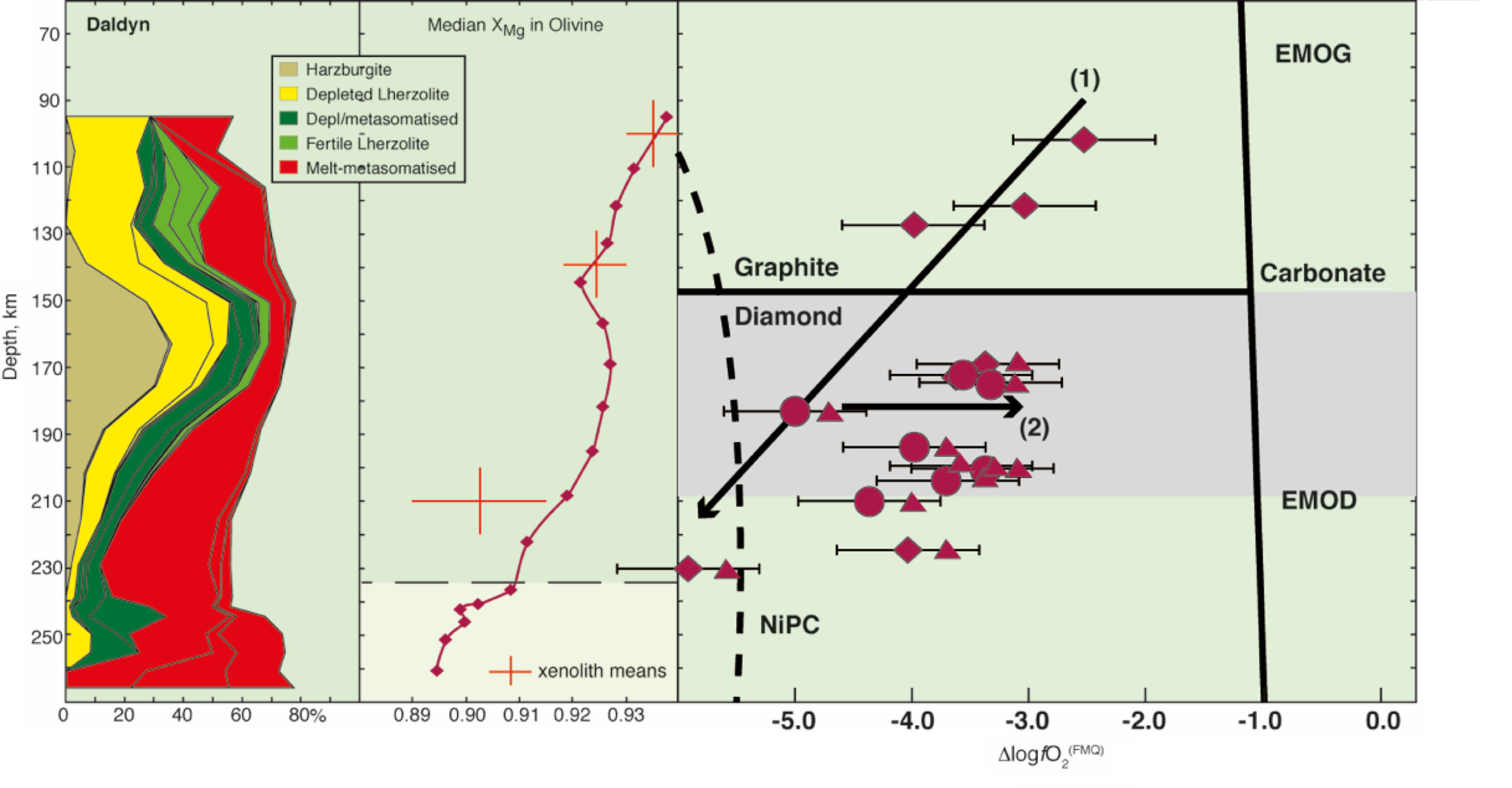
Figure 2. Left panel shows a lithospheric section of the SCLM beneath the Daldyn kimberlite field, constructed from garnet/ chromite concentrates (Griffin et al.,1996) showing vertical distribution of rock types and metasomatic styles. The middle panel shows the median values of XMg in olivine, reconstructed from garnet compositions and temperature); note the inverse correlation between XMg and the degree of melt-related metasomatism. The right-hand panel (after Yaxley et al., 2012) shows estimated fO2 based on Fe3+/εFe; depleted samples define a trend of decreasing fO2 with depth (Trend (1)), while metasomatised ones have experienced oxidation (Trend (2)). NiPC = Nickel Precipitation Curve.
If this process reflects the rise of CH4±H2 from the sublithospheric mantle, much of that mantle probably is metal-saturated, consistent with observations of metallic inclusions in sublithospheric diamonds (e.g., Smith et al., 2016). Such fluids could penetrate up into a primitive depleted cratonic root, establishing the observed trend of decreasing fO2 with depth (Fig. 2; Yaxley et al., Lithos 2012).
However, repeated metasomatism by silicic melts will raise the FeO content near the base of the craton, developing a carapace of oxidising material (Fig. 3). Oxidation of later CH4-rich fluids in this carapace would release CO2 and H2O to drive metasomatism and low-degree melting in the SCLM. This model can explain the genesis of cratonic diamonds from both reduced and oxidised fluids, the existence of SiC as inclusions in diamonds, and the abundance of SiC in some kimberlites.
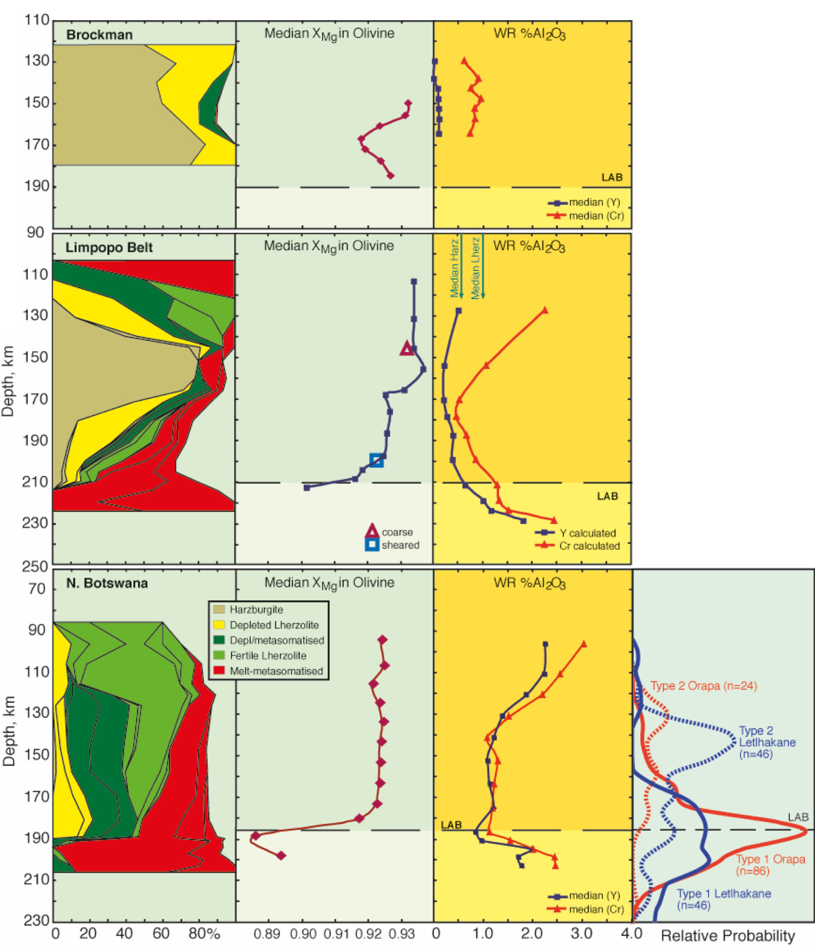
Figure 3. Lithospheric sections (as in Fig. 2) beneath three cratonic areas with kimberlites of different ages. The sections illustrate the development over time of an Fe-rich, melt-metasomatised carapace at the base of the SCLM, which would act as a filter to capture and oxidise (CH4+H2) rich fluids rising from the sublithospheric mantle. Estimates of the median Mg# of coexisting olivine, and of whole-rock Al2O3 content (based on two methods) are derived from the garnet data and illustrate the extent of metasomatism at each depth. Top: Brockman kimberlite (ca 1800 Ma), Pilbara Craton, W. Australia. This is the oldest and most primitive SCLM section known; it has experienced minimal refertilisation of the primary, highly depleted harzburgite. It would have very little buffering capacity and reduced fluids could penetrate well into it, producing an fO2 gradient like that seen in Figure 2. Middle: Limpopo Belt kimberlites (ca 500 Ma), South Africa-Zimbabwe. The refertilisation of the keel from the base is obvious, but the changes in Fe content are moderate and most pronounced in a 10-15 km thick zone at the base. Mean compositions and P-T estimates are shown for two types of peridotite xenoliths. Bottom: N. Botswana kimberlites (90-100 Ma). The metasomatic refertilisation has reduced the overall Mg# (and raised the Al content) of the whole section, but the most intense Fe-enrichment is concentrated in a 20-km thick zone at the base. Mean compositions and P-T estimates are shown for three types of peridotite xenoliths. There is a strong correlation of Fe enrichment with the distribution of eclogites, especially in the basal zone; Type I eclogites are typically heavily metasomatised. This Fe-rich basal barrier would represent a barrier to the passage of reduced fluids, and hence a source of CO2 and H2O for metasomatism and melt generation in this layer and above.
The recognition that CH4±H2 may accompany melts rising from a deeper, metal-saturated mantle also suggests an explanation for the zones of high conductivity that mark the tracks of mantle-derived magmatic systems (from kimberlites to Bushvelds). The oxidation of CH4 in rising fluids could propagate networks of microveinlets of amorphous carbon (even if later recrystallised to other forms), which might provide the fine-scale connectivity of conductive material in some mantle domains implied by the striking magnetotelluric images now becoming more widely available. See CCFS publications #830 and #968.
This project is part of CCFS theme 2, Earth’s Evolution, and contributes to understanding Earth’s Architecture and Fluid Fluxes.
Contacts: Bill Griffin
Funded by: CCFS Flagship Program 1
Phosphorites - Older than you think!
Phosphorites (sedimentary rocks with high contents of Ca-phosphate) are direct evidence in the rock record of oxygenation within the oceans and atmosphere. Phosphorites thus are restricted in age, first appearing about 2.2 Gyrs ago. They generally form as the result of microbial processes and in the Paleoproterozoic record, only occur as thin, peritidal deposits parallel to shorelines. In 2017 evidence of an older phosphorite, phosphate-rich microbial mats and peloids, was documented within the 2.4-2.3 Ga Turee Creek Group. The same carbonate reef that contains this phosphorite, also has very diverse stromatolites, thrombolites and deep-water microbial communities. Field work in 2017 enabled greater mapping of the 150 cm unit containing the phosphorous-rich microbial mats and established that they are adjacent to stromatolites with attached complex branching structures (Fig. 1).
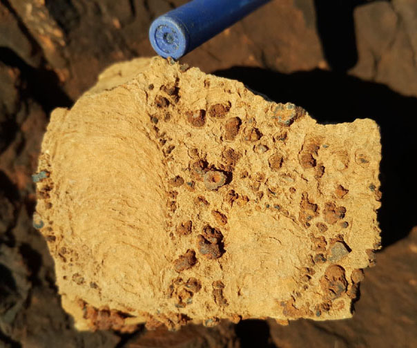
Figure 1. Float illustrating centimetre-scale stromatolites and attached millimetre-scale (red) branching structures (Photo: Martin Van Kranendonk).
The branching structures are unique to this site and could potentially represent a new form of complex life. Further work will investigate the potential relationship between oxygen in the water during the deposition of these rocks, and the increased complexity of structures within the reef, possibly as the result of life adapting to an oxygenated environment. Part of this work involves studying the range in morphology and the environment in which the branching structures developed, to determine whether these are a new form of complex life and whether there is a connection between their evolution and oxygen.
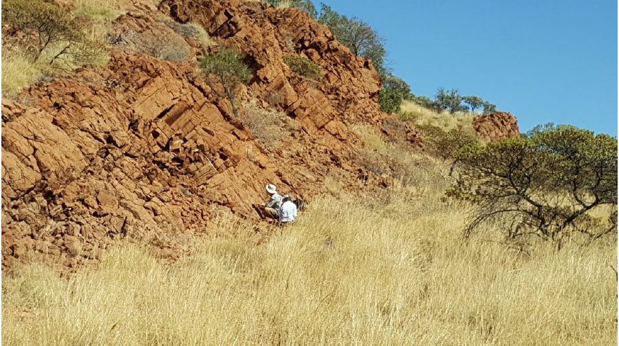
Figure 2. PhD Students Brendan Nomchong and Georgia Soares working hard in the field documenting the ridge (Photo: Martin Van Kranendonk).
This project is part of CCFS theme 1 Early Earth, and contributes to understanding Fluid Fluxes.
Contacts: Martin Van Kranendonk, Georgia Soares
Funded by: CCFS Flagship Program 4
Zircon signals mineralisation potential of Archean granites
Porphyry Cu deposits are major sources of Cu and Mo. They range in age from Archean to modern, although most are Jurassic and younger; porphyry deposits in Precambrian terranes are rare. Nevertheless, several porphyry-type Cu or Au deposits occur in the Superior Craton of Canada, and in the South West Terrane of the Yilgarn Craton, suggesting that their potential in Archean cratons may not be fully recognised.
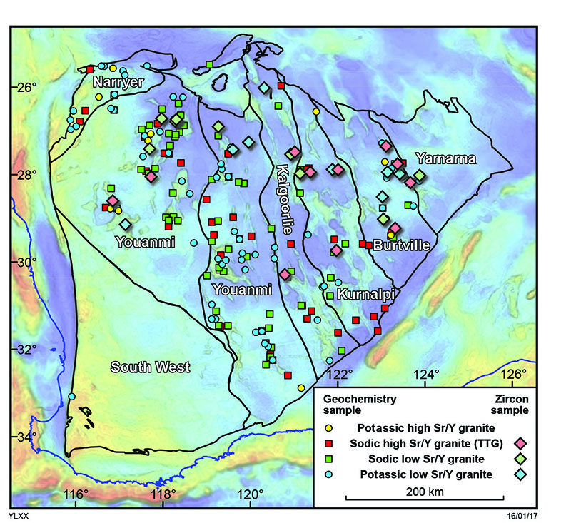
Figure 1. Granite whole-rock and zircon sample locations superimposed on a gravity image of the Yilgarn Craton, labelled by terrane.
In Phanerozoic porphyry Cu systems, mineralised magmatic rocks have distinctive chemical fingerprints, including high Sr/Y, V/Sc, Eu/Eu*, and (Eu/Eu*)/Y ratios. Zircons in these rocks also have distinctive compositions, such as higher Eu/Eu* ratios. These signatures can be attributed to high magmatic water and sulfur contents and high oxidation states and can be used as indicators of ore fertility.
To test whether these fertility indicators can be applied to Archean granitic rocks across the Yilgarn Craton, we have compiled GSWA geochronology and geochemistry data for 230 unaltered and non-mineralised granites. The granitic rocks are divided into four groups (Fig. 1).
We also examined >2000 trace element analyses of zircons from 42 Yilgarn granite samples (Fig. 1). We compared Yilgarn granites with well-characterised hydrous and oxidised Miocene Cu-mineralised granites in southern Tibet. The Tibetan granites crystallised from very hydrous magmas with >10 wt% water contents at depth, resulting mainly from high-pressure differentiation of hydrous mafic melts of Tibetan mantle.
Figure 2a shows that neither hydrous melting nor dehydration melting of mafic lower crust can produce melts with Mg# >50. Tibetan granites typically have Mg# >50 (Fig. 2a), consistent with input of primary mafic magmas through magma mixing. In contrast, most Yilgarn granites have Mg# <50, suggesting derivation mainly through crustal melting with limited mantle input.
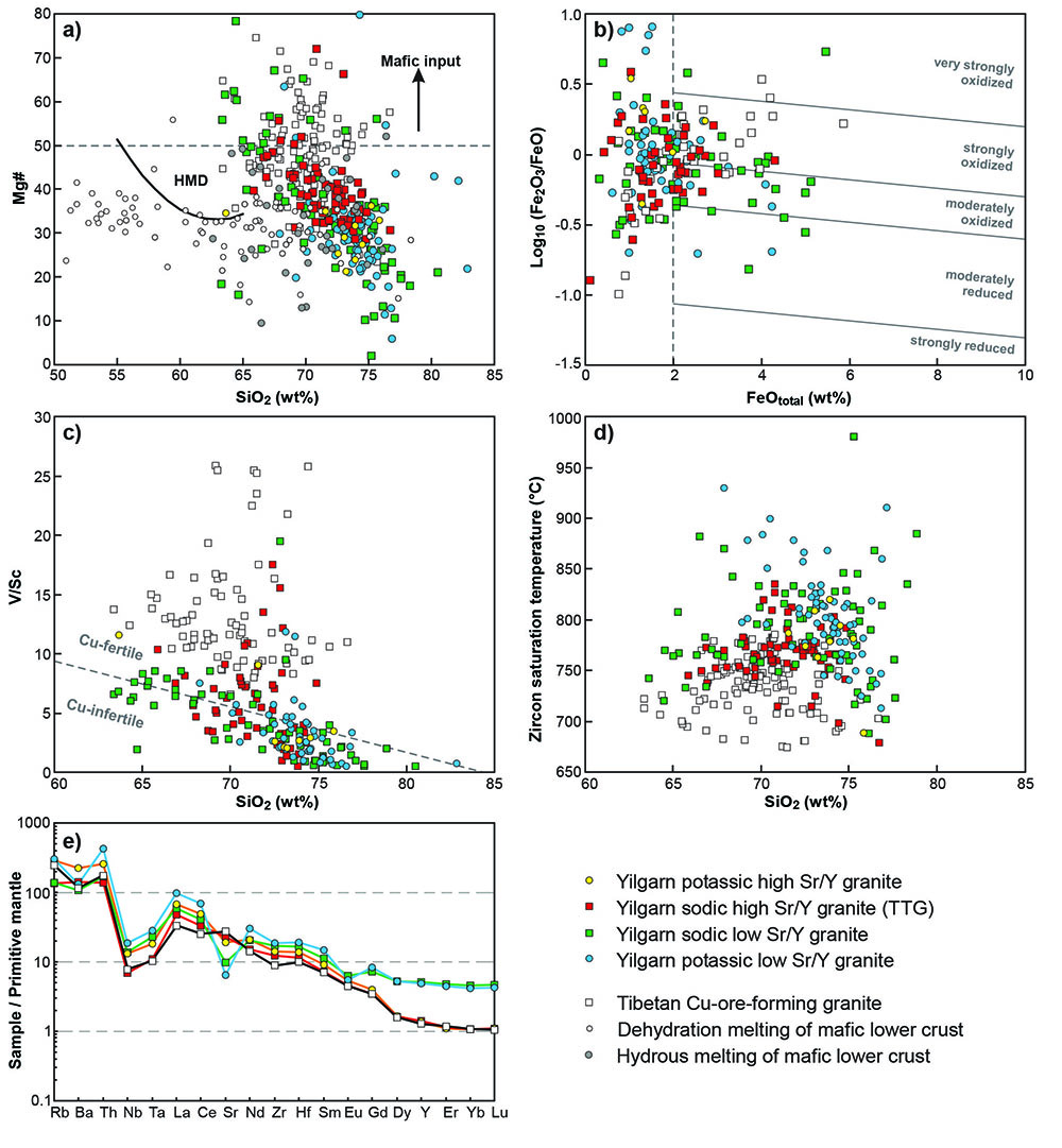
Figure 2. Whole-rock compositions of Yilgarn granites.
Yilgarn high-Sr/Y granites are moderately- to strongly oxidised, whereas low-Sr/Y granites are moderately reduced to strongly oxidised (Fig. 2b). Tibetan Cu-mineralised granites are mainly strongly oxidised and tend to have higher Fe2O3/FeO at a given FeOtotal, suggesting that Tibetan granites are generally more oxidised (Fig. 2b).
Most Yilgarn granites plot in the Cu-infertile field in a diagram of V/Sc vs SiO2 (Fig. 2c), whereas all Tibetan Cu-mineralised granites plot in the Cu-fertile field. High V/Sc is caused by amphibole fractionation, which removes Sc, and by suppression of magnetite fractionation, which increases V in an oxidised and hydrous melt. The average V/Sc ratio for each group of Yilgarn granites is significantly lower, suggesting that Yilgarn granites are less fertile than Tibetan granites because the former are generally less oxidised and less hydrous. Zircon saturation temperatures indicate that Yilgarn granites crystallised at higher temperatures than Tibetan granites (Fig. 2d), which also suggests the magmas were less hydrous.
The trace-element patterns of Yilgarn high-Sr/Y and low-Sr/Y granites are distinctly different (Fig. 2e). High-Sr/Y granites are characterised by an absence of Sr and Eu anomalies, and depletion in heavy rare earth elements (HREE). Yilgarn low-Sr/Y granites have significant negative Sr and Eu anomalies and elevated HREE concentrations (Fig. 2e). These features suggest that Yilgarn high-Sr/Y granites were derived from high-pressure melting of mafic crust within the garnet stability field, whereas low-Sr/Y granites originated mainly from low-pressure melting of crust within the plagioclase stability field. Tibetan Cu- mineralised granites have similar HREE patterns to the Yilgarn high Sr/Y granites, but are more enriched in Sr and depleted in Zr (Fig. 2e), consistent with their derivation from high-pressure differentiation of more hydrous melts.
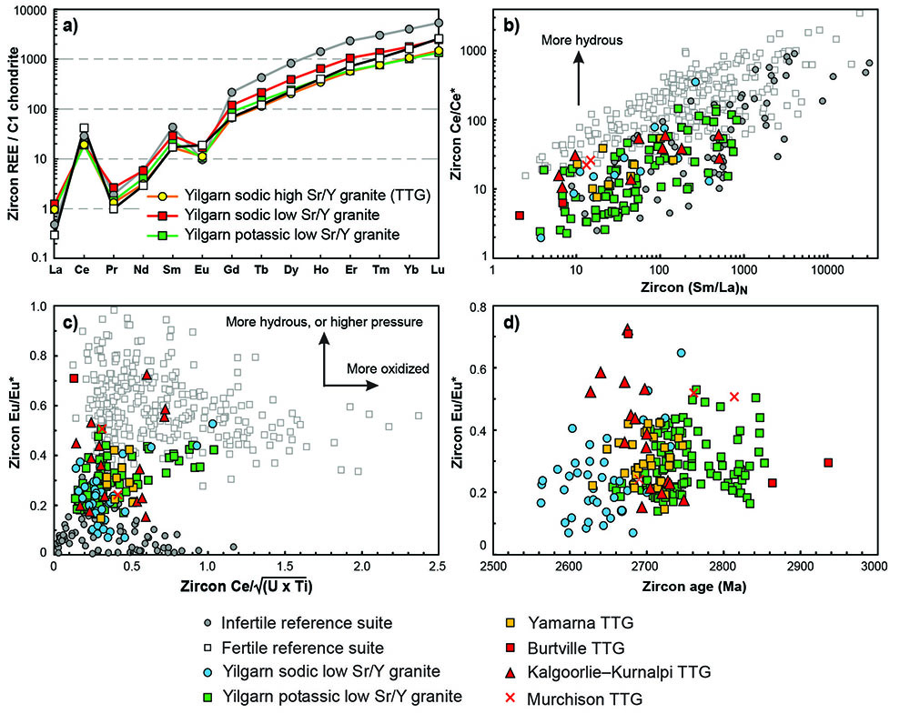
Figure 3. Compositions of zircons from Yilgarn granite
We also compared trace-element compositions of zircon in Yilgarn granites with those of reference suites from infertile and fertile granites. The zircon REE patterns of Yilgarn granites are similar to both Phanerozoic fertile and infertile suites (Fig. 3a). However, Yilgarn granites have consistently lower zircon Ce/Ce* and Eu/Eu* than Phanerozoic fertile suites (Fig. 3b, c), suggesting they were less hydrous than fertile suites.
Zircon Ce/√(U x Ti) was recently proposed as a proxy for magma oxidation state. Values for Yilgarn granites are lower than those for Phanerozoic fertile suites and similar to those of infertile suites. This also suggests that Yilgarn granites are less oxidised than Cu-fertile granites (Fig. 3c), and this is consistent with interpretations from whole- rock Fe2O3/FeO data (Fig. 2b).
Both whole-rock and zircon compositions indicate that many Yilgarn granites are less hydrous and less oxidised than Phanerozoic Cu-mineralised granites. The systematic difference in zircon chemistry between Archean granites and Phanerozoic fertile and infertile suites suggests that different processes were involved in forming Archean granites. We argue that Archean high-Sr/Y granites were formed mainly through intracrustal partial melting of mafic lower crust in the garnet stability field, whereas Phanerozoic fertile suites were formed by intracrustal amphibole-dominated fractionation of mafic magmas. Granites formed by the former process have lower potential for porphyry Cu mineralisation due to insufficient water and the absence of copper and sulfur accumulation in the melt.
This project is part of CCFS theme 2, Earth’s Evolution, and contributes to understanding Earth’s Architecture.
Contacts: Yongjun Lu, Hugh Smithies, Michael Wingate, Noreen Evans, Paul Morris, David Champion, Cam McCuaig
Funded by: CCFS Flagship Program 7
Seismic image of the Capricorn Orogen – revealing the mantle component
The Proterozoic Capricorn Orogen in central Western Australia (Fig. 1) records the collisions of the Archean Pilbara and Yilgarn Cratons to form the West Australia Craton during two stages of Paleoproterozoic orogeny: 1) the 2.21-2.14 Ga Ophthalmian Orogeny, when the Glenburgh Terrane, a microcontinent between the Pilbara and Yilgarn, first collided with the Pilbara Craton; 2) the 2.00-1.95 Ga Glenburgh Orogeny, when the combined Pilbara Craton/ Glenburgh Terrane further collided with the Yilgarn Craton to form the West Australia Craton. After the final assembly, the Capricorn Orogen was affected by more than 1 billion years of episodic intracontinental reworking and reactivation processes.
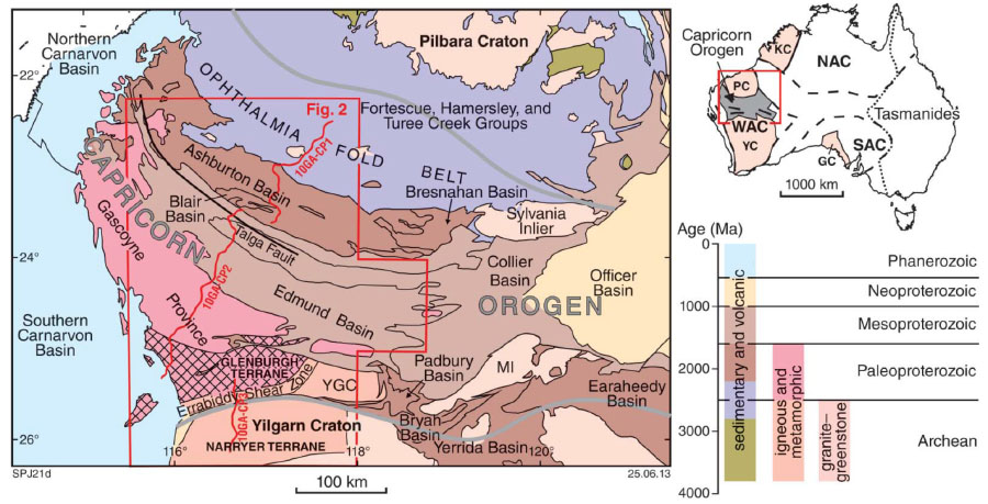
Figure 1. Tectonic map of the Capricorn Orogen modified from Johnson et al. (2013). Black N-S lines are the seismic transects shown in Figure 3.
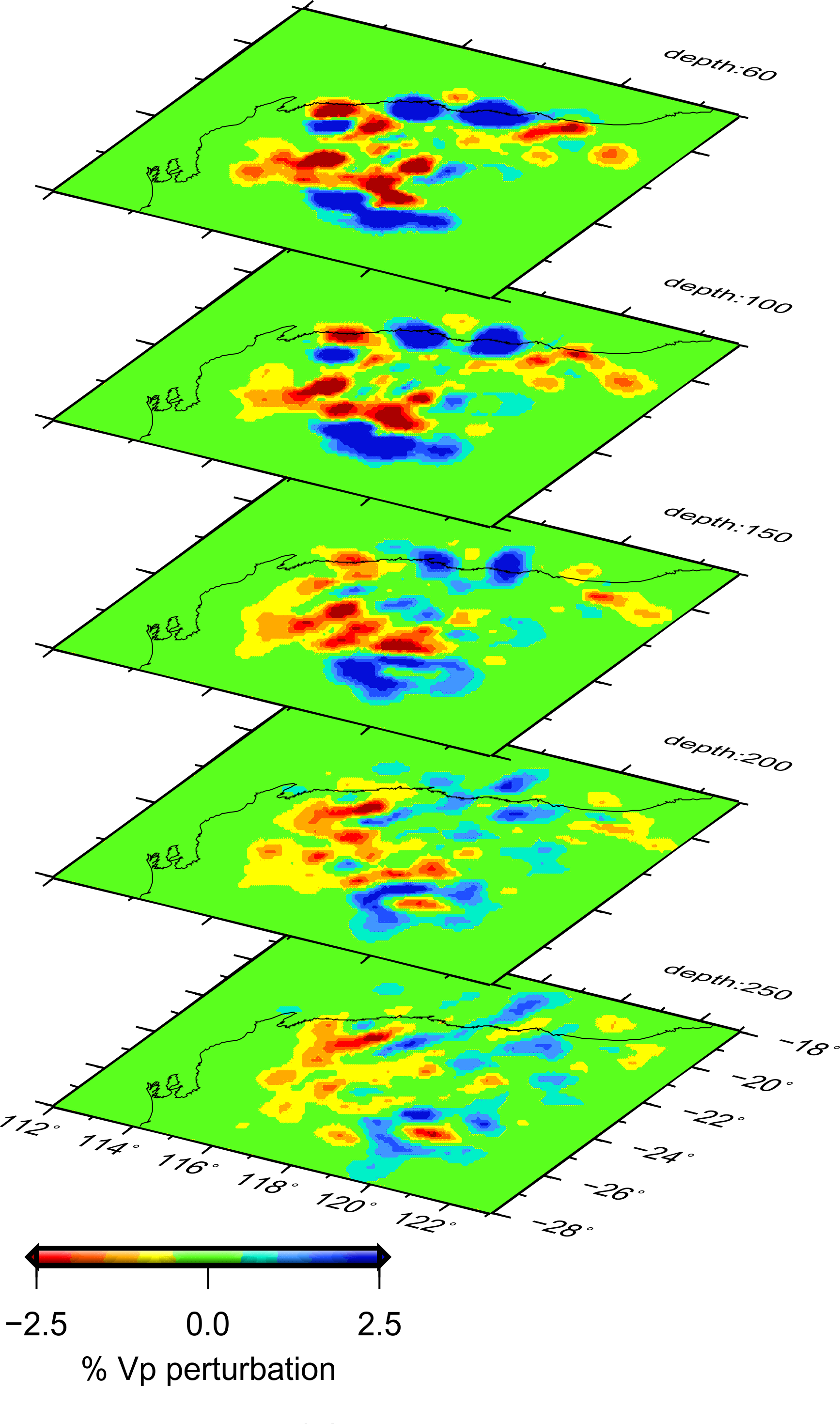
Figure 2. Map views of the preliminary P-wave velocity model.
To evaluate how these tectonic processes have imprinted the orogenic lithosphere, and thus shed light on the dynamics of early continental collision and stabilisation, we conducted a finite-frequency body-wave tomographic study, taking advantage of the new data recorded by a portable seismic array COPA (Capricorn Orogenic Passive-source Array, part of the SIEF program, Distal Footprint of Gigantic Ore systems - a Capricorn Case Study), which has been in the field since April 2013. We were able to extract travel-time information from 486 teleseismic events. We also incorporated data recorded during earlier field campaigns conducted by ANU.
Our provisional tomographic model reveals the following intriguing observations: 1) the Capricorn orogen is imaged clearly as a significant low-velocity anomaly, extending downwards to nearly 250 km depth, rather than a more typical high-velocity cratonic root. The low velocity may reflect the effects of punctuated lithospheric reworking and reactivation during the cratonisation processes; 2) the Glenburgh Terrane is underlain by a high-velocity anomaly ~150 km thick; 3) the northern edge of the Yilgarn Craton is characterised by a high-velocity anomaly that extends northwards to ~300 km depth beneath the Capricorn Orogen; and 4) the tomographic model captures likely remnant subducted slab pieces which are now part of the cratonic lithosphere.
This project is part of CCFS themes 1, 2 and 3, Early Earth, Earth’s Evolution and Earth Today, and contributes to understanding Earth’s Architecture.
Contacts: Xiaobing Xu, Liang Zhao, Huaiyu Yuan
Funded by: CCFS Flagship Program 7
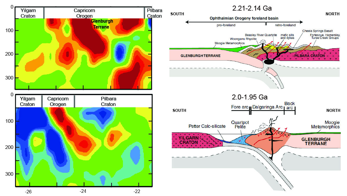
Figure 3. Cross-sections of the velocity model and correlation with the two Paleo-Proterozoic orogenies.
New petrogenetic model for the adakitic magmatism of Patagonia and the Austral Volcanic Zone
The ‘Adakites’ from the Patagonian Cordillera and the Austral Volcanic Zone (AVZ) on the southwest margin of South America are widely regarded as true slab-melts, rare on Earth. These differ from ordinary calc-alkaline arc andesites and dacites by steeper REE patterns with low concentrations of HREE and Y, and high values of Mg#, Cr, Ni, and Sr for SiO2 contents mainly in the range 56-63 wt%. The steep REE patterns have been interpreted as evidence for partial melting of eclogite in the subducting plate, by analogy with the ‘adakites’ on Adak Island in the central Aleutian arc. However, an alternative interpretation of the type ‘adakite’ by petrogenesis differentiation of hydrous magmas at high pressure and temperature is suggested by: 1) recognition of xenolith suites as cognate cumulates; 2) seismic evidence of a slab-mantle interface to at least 270 km depth under the central Aleutians, which means that slab temperature is less than 650°C under the volcanic front, too cool to be melted; and 3) along- arc variations of tectonic stress. This project will explore this alternative interpretation in the Plio-Holocene volcanic centres of the AVZ, as well as the mid-Miocene Patagonian ‘adakites’.
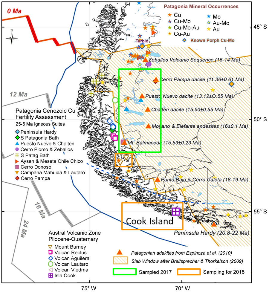
Figure 1. Distribution of the Miocene Patagonian Adakites and the Austral Volcanic Zone with Sampling Locations in this project.
Why Patagonia? The western margin of Patagonia has experienced the subduction of the Chile Rise since ~22 Ma. A series of adakitic igneous complexes is correlated with the northward-propagating compressive deformation wave, which seems to be associated with the young, warm and buoyant southern part of the subducted Nazca Plate. On the other hand, all six Holocene volcanic centres of the Andean AVZ (49-54°S), associated with subduction of the Antarctic Plate under the South American and Scotia Plates, have erupted exclusively adakitic andesites and dacites. The presence of these two scenarios in one tectonic setting makes Patagonia a perfect location to understand the genesis of adakitic magmas.
The project integrates whole-rock geochemistry with U-Pb dating and trace-element analysis of zircons (in situ and detrital). Cathodoluminescence (CL) images will be used to search unzoned cores in zircon grains, which could imply deep, slow crystallisation of the plutonic rocks. We also will perform Al-in-hornblende (EPMA) barometry on hornblende phenocrysts in host rocks and plutonic enclaves at the CMCA (UWA).
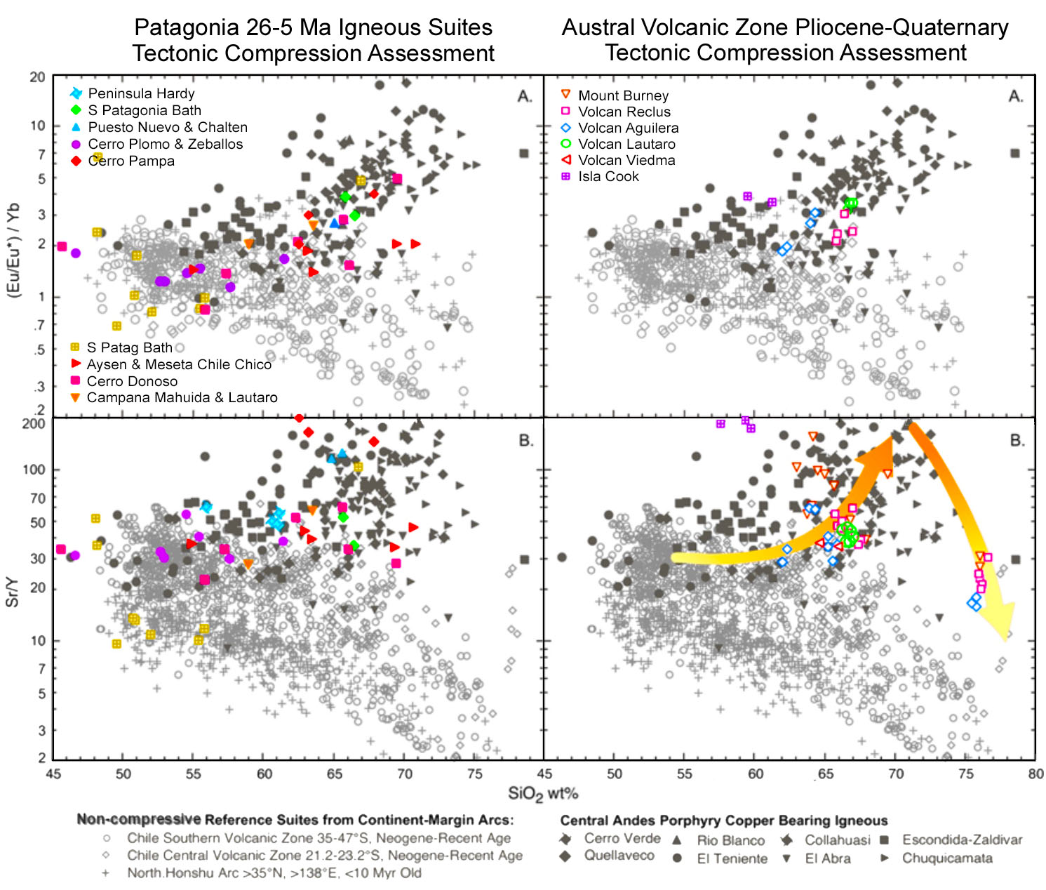
Figure 2. High-pressure magmatic evolution of Patagonian Igneous Centres exposed by use of Sr/Y and (Eu/Eu*)/Yb ratios. Over ~400 geochemical analyses from the Patagonian region were compiled from literature and added to Robert Loucks’ Global Data Base, according to 3 main criteria: Sr/Y > 35 and/ or (Eu/Eu*)N/YbN > 1.9 and SiO2 > 57 wt%.
Rock and stream sediments were taken from 5 mid-Miocene igneous centres, during 2017 in Patagonia (Chile and Argentina). Zircon separation and CL Imaging and geochemical sample preparation have already been done at the School of Earth Sciences and the CMCA (UWA). Over 2000 zircon LA-ICP-MS analyses were performed at QUT to November 2017, in addition to 15 whole-rock analyses (LabWest, Perth). Field work in 2018 will sample 2 adakitic volcanoes from the AVZ.
This project is part of CCFS theme 2, Earth’s Evolution, and contributes to understanding Earth’s Architecture and Fluid Fluxes.
Contacts: Gonzalo Henriquez, Marco Fiorentini, Bob Loucks
Funded by: CCFS Flagship Programs 2 and 3
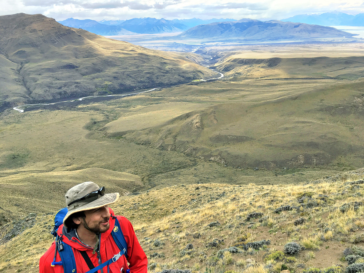
Gonzolo Henriquez enjoying the magnificent views during fieldwork in the Cerro Moyano, Patagonia - Argentina (Photo: Mario Coloma).