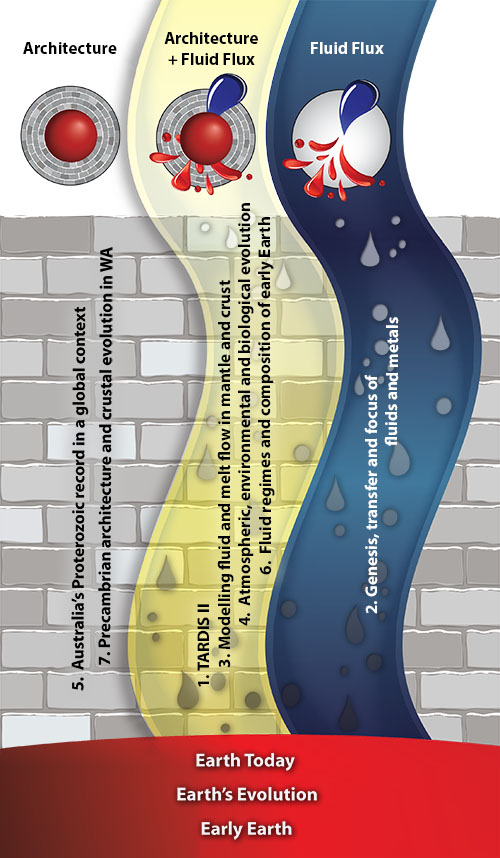
Research Highlights 2015
Following the new conceptual framework outlined here, these Research Highlights are identified as contributing to understanding Earth Architecture (the roadmap for fluids) and/or Fluid Fluxes (the “traffic report”), with logos for easy attribution. For a full description of the Foundation Programs, see Appendix 1. and for the Flagship Programs see Appendix 2.
COPA: the Capricorn Orogen Passive-source Array
The SIEF Project
In 2013, a major Science and Industry Endowment Fund (SIEF) project, the ’UNCOVER Australia: Capricorn Distal Footprints Project‘ was awarded to CSIRO, UWA, Curtin and GSWA. The SIEF project is one of the largest multi-method surveys attempted in Australia and aims to image the lithosphere from very shallow to its deeper levels. The project builds on current knowledge to deliver improved understanding of the evolution and controls on mineral systems in the Capricorn. The end goal is to apply these generic learnings elsewhere in order to develop a set of integrated large-scale geological and geophysical datasets that can assist in constraining whole lithosphere architecture and tectonic evolution and boost exploration discovery success in covered terrains in Australia
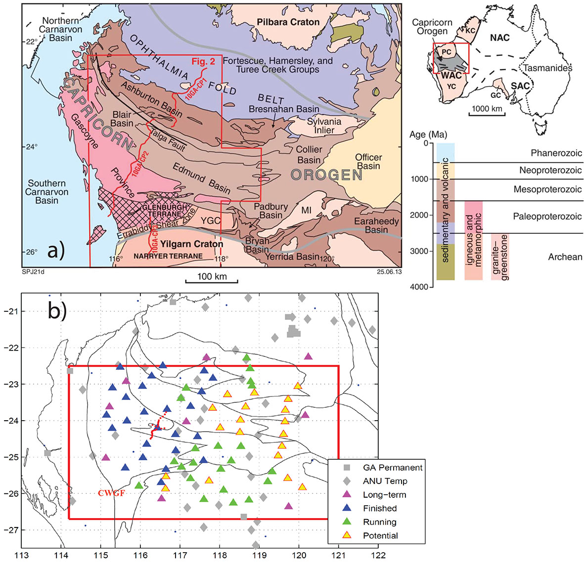
Figure 1. a) The Capricorn Orogen. b) The seismic deployment - spatial coverage of the seismic stations. Elements of the orogen and surrounding cratons and basins are marked. Modified from Johnson et al. (2013).
The Capricorn Orogen
The Capricorn Orogen of Western Australia is a 1000 km long, 500 km wide region of variably deformed rocks located between the Pilbara and Yilgarn Cratons (Fig. 1a, right). It records the Paleoproterozoic assembly of these cratons to form the West Australian Craton, and over one billion years of intracratonic reworking that followed. Owing to this reworking, the location of major crustal structures and the broad architecture of the orogen are poorly constrained. To improve the exploration potential of the region, a better understanding of the crustal architecture across the orogen is critical, especially identification the location and orientation of major crustal structures and craton edges, as well as any island arcs, or exotic accreted crustal material (Johnson et al., Australian Journal of Earth Sciences, 60, 681-705, 2013; Fig. 1a).
The COPA Deployment
The overall goal is to integrate other geological and geophysical datasets and produce 3D multiple-scale seismic images across the orogen. This will provide direct constraints on local geological models for the timing and kinematic evolution of faults and shear zones in the region and its 4D metallogenic history. We will also provide new insights on the tectonic amalgamation of the Western Australian craton. The main tools of the project are seismic tomography (body waves and surface wave/ambient noise) and receiver function CCP imaging. These two commonly used earthquake-seismology methods best fit the 2D design of the passive source project.
With a careful design of a 2D array that takes advantage of previous passive-source studies in the region, the proposed long-term and short-term deployments give us a 2D grid that spans a nearly 500 km by 500 km surface area. Station spacing is roughly 40 km and the 36 months in total deployment will guarantee enough data recording for 3D structure imaging using body wave tomography, ambient noise surface wave tomography and P- and S-wave receiver function Common Conversion Point (CCP) stacking techniques. 34 sets of seismometers loaned from the ANSIR national instrument pool (with 2 as backup) have been deployed in the western half of the orogen since March 2014. In October 2014 a 25-site High-resolution Passive Source (HPS) array was also deployed, with varying 2, 4, and 8 km station spacing to focus on shallow crustal structure across the Collier Basin, Edmund Basin and the Gascoyne Province. The HPS array was deployed in October 2015.
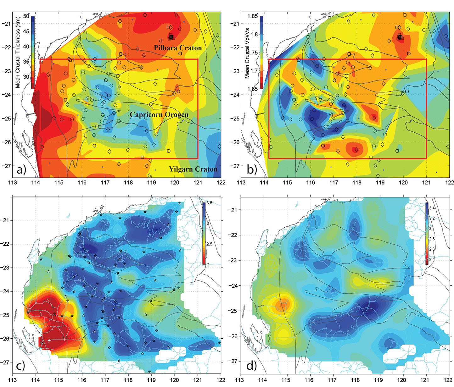
Figure 2. Preliminary results from the COPA deployment. a) and b), mean crustal thickness (in km) and Vp/Vs ratio. c) and d), shear wave velocity maps from ambient noise showing peak period at 2.5 s and 15 s, corresponding to maximum sensitivity at 3 and 20 km, respectively.
Preliminary Results: Bulk Crustal Structure
In the passive-source studies, we will test several hypotheses that 1) distinct crustal blocks are seen continuously throughout the orogen (using ambient noise/body wave tomography); 2) distinct lithologies are present in the crust and upper mantle across the orogen (using receiver function CCP images); and 3) crustal and lithosphere deformation along craton margins in general follows “wedge” tectonics (e.g. subduction of juvenile blocks under the craton mantle, on craton-ward dipping sutures; Snyder, Tectonophysics, 355, 7-22, 2002).
Preliminary results of the crustal structure in the orogen are available from seismic receiver functions. A simple H-k stacking technique (CCFS publication #649;Research highlightpp. 64-65) stacks available receiver functions to obtain an optimum pair of bulk crustal thickness (H) and Vp/Vs ratio (k; equivalent to Poisson‘s ratio; an indicator of crustal rock composition). The maps show bulk crustal thickness, Vp/Vs ratio, bulk crustal Vp velocity and the crustal density anomaly from gravity inversions. The western Capricorn Orogen is thicker, denser and higher-velocity, compared to the two cratons. Compositionally the western orogen is complex - it may indicate that different terranes of deformation processes were involved during the amalgamation of the WA craton in the Proterozoic. The northern margin of the Yilgarn Craton shows anomalously thicker, denser and higher velocity crust, and abrupt changes in the crustal conductivity are also observed in the MT study.
A tomographic inversion using ambient noise is currently being conducted to obtain shear wave velocities in a 3D volume of the orogenic crust. Available data for all possible station pairs are cross-correlated and stacked to obtain the empirical surface wave traveling between the station pair. Phase and group velocities can be measured for each station pair, which forms a path in a tomographic problem. Figure 2 shows the group velocity tomographic results at period 2.5 s (~3 km peak depth); and period 15 s (mid-crust). Significant structural differences are evident in the shallow and mid-crust. The high-velocity northern margin of the Yilgarn Craton is prominent, as seen previously in the receiver functions and MT images. The 3D tomographic model of shear velocity is under construction. More data are expected from the deployment to push the imaging capability to the lower crust, and to extend the horizontal coverage in the eastern Capricorn Orogen by April 2017.
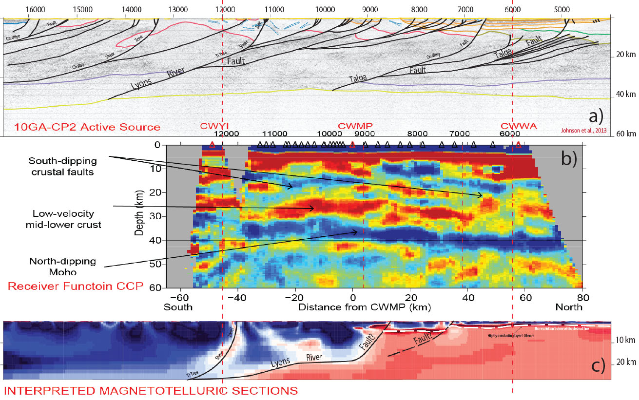
Figure 3. Comparison of the crustal scale results along the high resolution line from the active source (a; Johnson et al., 2013), the passive source CCP stack (b; this study); and the MT (c; Heinson et al., 2012). Note the prominent Moho interface, the truncations of crustal discontinuities, and the low-velocity mid- to lower crust inferred from the negative velocity contrast.
Preliminary Results: A High Resolution Crustal Cross-section
A receiver function CCP (common-conversion-point) stack is applied to the high resolution line (HPS) to reveal crustal discontinuities. The results show good correlation with the active source and magnetotelluric studies (Johnson et al. 2013; Heinson et al., GSWA Report 2012). The passive source CCP image shows comparable crustal structures: north-dipping Moho; and south-dipping crustal faults (truncated crustal discontinuities). A slow-velocity mid- to lower crust is inferred from the negative velocity gradients in the centre of the array, consistent with the ambient noise observations, and the highly conductive mid-crust in the MT image.
This project is part of CCFS Theme 3, Earth Today, and contributes to understanding Earth‘s Architecture.
Contact: Huaiyu Yuan
Funded by: CCFS Flagship Program 7, SIEF
The sulfur cycle in the Palaeoproterozoic Earth
The Earth‘s crust is a complex and dynamically evolving chemical interface between two convective fluid systems: the endosphere (linked core and mantle) and the exosphere (linked hydrosphere and atmosphere). The nature of the physical and chemical processes that occur on the surface of the planet are intimately linked by the energy available from the sharp chemical and thermal gradients that exist across this interface. On modern Earth, island/volcanic arcs are the direct consequence of subduction processes that occur at convergent plate boundaries, and are the factories where juvenile continental crust is formed and where explosive volcanic eruptions emit large quantities of gases into the atmosphere. There remains considerable uncertainty with respect to the key processes that occurred during the transition from the Archaean to the modern Earth. One of the key questions is whether ancient arcs behaved similarly to modern ones. The fragmented geological record of the Palaeoproterozoic (2.5-1.6 billion years ago) and Archaean (>2.5 billion years ago) eons makes it difficult to answer these questions with any certainty, allowing for a proliferation of inferences and unanswered questions.
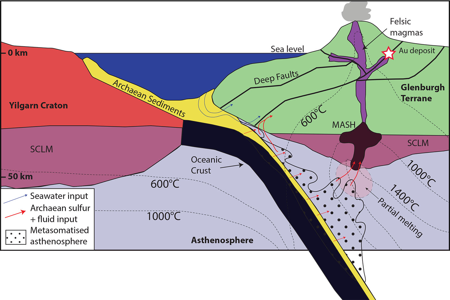
Figure 1. Schematic section through the Glenburgh continental arc system at ca 2.0 Ga, prior to collision between the Archean Glenburgh Terrane and Yilgarn Craton. This diagram highlights the development of a MASH (Melting, Assimilation, Storage, Homogenisation) zone where mafic magmas generated from partial melting of the metasomatised asthenosphere and subcontinental lithospheric mantle (SCLM) pool at their level of neutral buoyancy and differentiate into more buoyant felsic melts, which then ascend through the crust along major fault zones to produce the felsic magmatism, i.e. the Dalgaringa Supersuite, observed in the Glenburgh Terrane. Archaean sulfur and gold bearing fluids would also travel up these deep faults where they may interact with seawater, generating the observed sulfur isotope ‘mixing line‘.
A key insight into this knowledge gap comes from better understanding the shift in the isotopic signature of sulfur through time. Sulfur is a key volatile element that is cycled between the different crustal and mantle reservoirs during arc magmatism, and thus may be used as a tracer. However, the cycle of sulfur between the inner parts of our planet and the atmosphere in the Palaeoproterozoic remains poorly constrained. As a result, our understanding of the development of early life and many other earth processes in which sulfur plays a key role, including climate change, biological evolution and ore deposit genesis, have been hindered. We need isotopic markers that can trace the sources and map the path of this element through the uppermost layers of the upper mantle and crust (the lithosphere).
The discovery of the presence of anomalous mass-independent fractionation of sulfur (MIF-S) signatures in Archaean sedimentary rocks provides a revolutionary way to probe the global sulfur cycle. These anomalies occur because in the ancient atmosphere, which lacked ozone, cosmic radiation could produce isotopes (such as 33S) that are not formed now. This study focuses on the Palaeoproterozoic Glenburgh sulfur-bearing gold deposit, which is a natural laboratory ca 2 billion years old, hosted in the Glenburgh arc of Western Australia. Because this arc developed at the margin of a subducting Archaean block, we applied multiple sulfur isotope analysis as a chemically conservative tracer to test whether Archaean MIF-S sulfur could be detected. Results show that Archaean sulfur can be traced throughout the Palaeoproterozoic Glenburgh arc (Fig. 1).
This is an extraordinary discovery as it provides key constraints on the sources of volatiles and metals in arc environments. This is still a heavily debated topic, as there is a mass-balance problem between the known concentrations of these elements in the mantle wedge below arc systems and the observed concentrations in arc magmas and associated mineralisation. Some workers have suggested that, particularly in the case of gold deposits formed in continental arcs, the ultimate source of gold is from subducted carbon-rich sedimentary rocks attached to the downgoing slab. In fact, since gold is insoluble in H2O, it is thought that it may be mobilised in the form of Au sulfide complexes in fluids at high temperatures and pressures, such as those found in arc magmatic environments. Therefore, the isotopic composition of sulfide should also reflect a similar source, as is demonstrated in the dataset presented in this study.
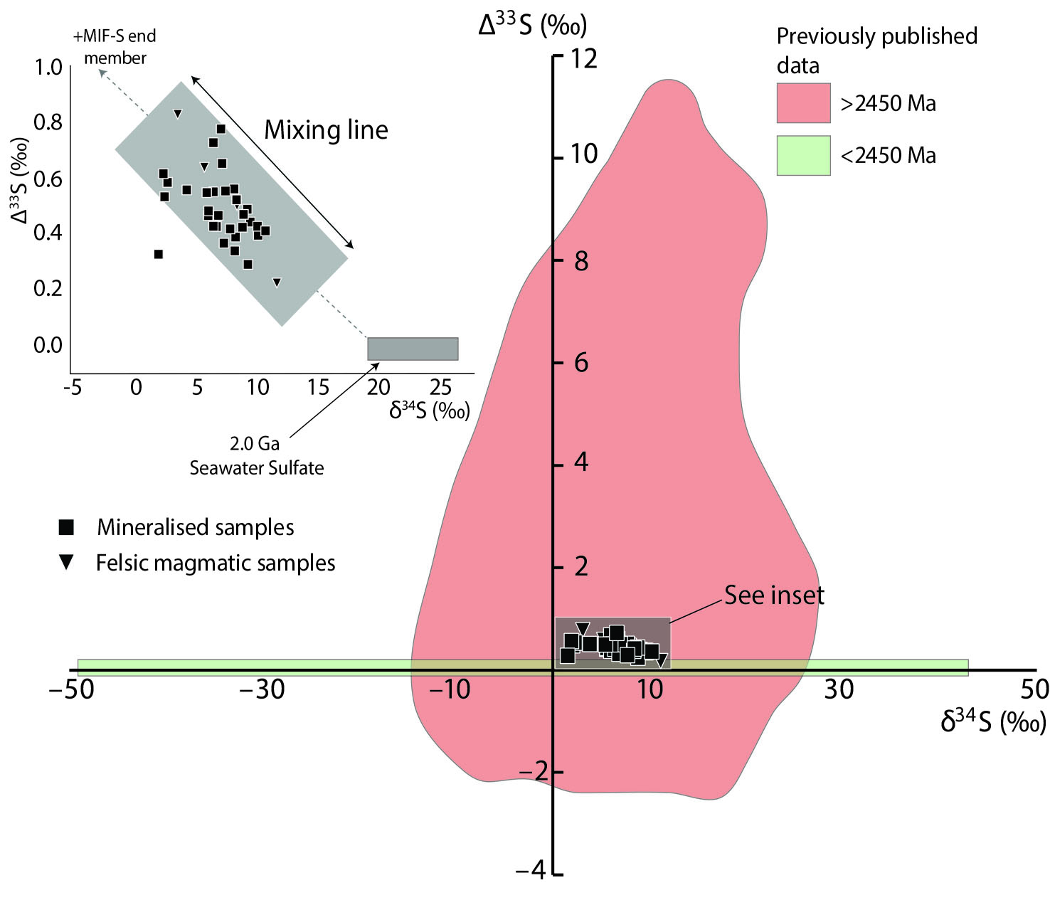
Figure 2. Δ33S versus δ34S from Glenburgh (this study) compared to previously published S-isotope data. Points shown have error bars smaller than the size of the points in all cases.
The application of spatio-temporally constrained chemically conservative isotopic tracers such as MIF-S is critical for a better understanding of tectonic processes that drive fluid and metal transfer from Archaean cratons into their reworked margins and the operation of arc magmatism. At the Glenburgh deposit, mixing between sulfur isotope end-members (Paleoproterozoic seawater-derived sulfate and Archaean shale-derived pyrite; Fig. 2) is, in effect, recording the progressive closing of an ocean and a tectonic switch from subduction of oceanic crust to the onset of continent-continent collision with the Yilgarn Craton. Hence, multiple sulfur isotope data are able to image a process that is cryptic in most other currently available datasets, showing that sulfur cycling in arc settings occurs on very large scales, from the atmosphere-hydrosphere through to the lithosphere during crustal generation. If this happened in the Archean, it presumably could have happened throughout geological history, although we have no equivalent tracers for post-Archean processes.

This project is part of CCFS themes 2 and 3, Earth‘s Evolution and Earth Today, and contributes to understanding Earth‘s Architecture and Fluid Fluxes.
Contacts: Vikraman Selvaraja, Marco Fiorentini, Crystal LaFlamme, Boswell Wing
Funded by: MRIWA Distal Footprint Capricorn Study, umbrella of - but not funded by - CCFS Flagship Program 4
Primitive pyroxenites delaminated from ancient island arc
One of the major debates of modern petrology, known as the continental crust paradox, arises essentially from the discrepancy between the net basaltic output of modern arc magmatism and the average andesitic composition of the continental crust. If any post-Archean continental crust was to be made by arc magmatism, this paradox needs to be resolved. Among the potential explanations is that the mafic-ultramafic counterpart of the differentiated felsic crust had to be removed. After being postulated theoretically, and explained numerically and experimentally, the delamination (i.e. convective removal) of dense arc cumulates has been seismically evidenced. However, field evidence for this key geological process has been hard to find.
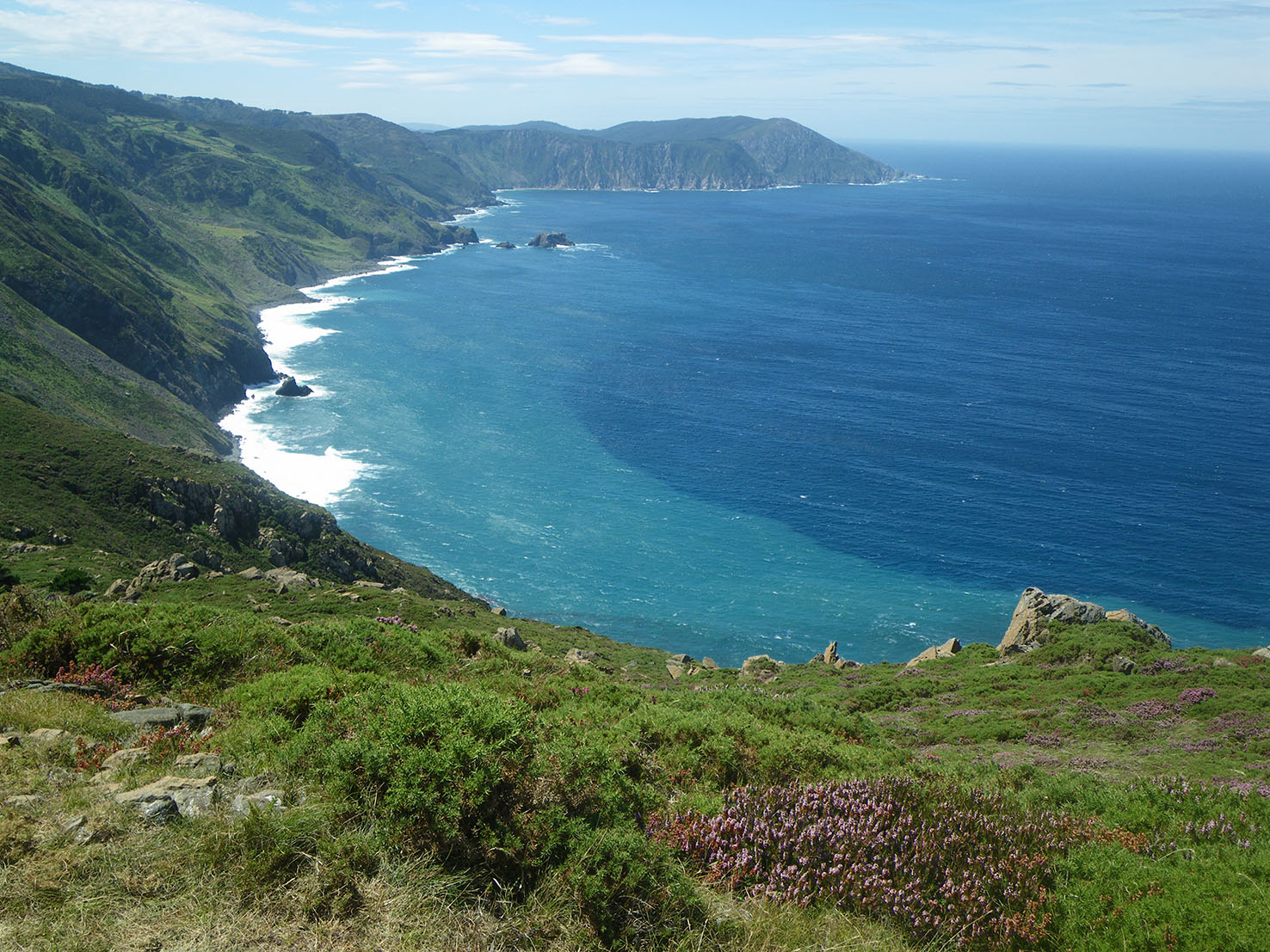
Figure 1. The Herbeira cliffs (621 m) of northern Galicia, Spain are the highest sea cliffs in continental Europe. They expose the largest mafic-ultramafic section of the Cabo Ortegal Complex, one of the only sub-island-arc mantle exposures in the world.
In north-western Spain, the Herbeira massif of the Variscan Cabo Ortegal Complex hosts one of Earth‘s rare exposures of sub-island-arc mantle. New field and petrographic investigations of this 600 m-thick mafic-ultramafic section have defined a crystallisation sequence of primitive cumulates (dunites ± chromitites, wehrlites and olivine websterites). Their particularly high CaO/Al2O3 (2.2-11.3), high concentrations of compatible elements and a signature of high large ion lithophile elements (LILE) / high field strength elements (HFSE) implies a origin from unusual arc magmatism. High-Ca parental melts of boninitic to picritic affinities were generated from shallow (< 2 GPa) fluid-fluxed melting of a refractory lherzolite, involving carbonatite metasomatism. Following dynamic melt-rock interaction at shallower depths (< 1.2 GPa), massive websterites and rare opx-rich websterites were produced. Chromatographic reequilibration accompanied the late magmatic migration of residual melts, which produced a wide range of rare-earth-element (REE) patterns.
Textural observations and preliminary electron back-scattered diffraction (EBSD) data indicate that Cabo Ortegal pyroxenites and their host peridotites record the development of sheath folds and mylonites during high shear-strain deformation, following high-temperature deformation. Peak metamorphism was reached under eclogite-facies conditions (1.6-1.8 GPa and 780-800°C) and exhumation into amphibolite-facies conditions then occurred. This complex tectonothermal record encapsulates delamination, high-pressure metamorphism, and exhumation of the arc root, which resulted from gravitational instabilities and subduction- channel processes.
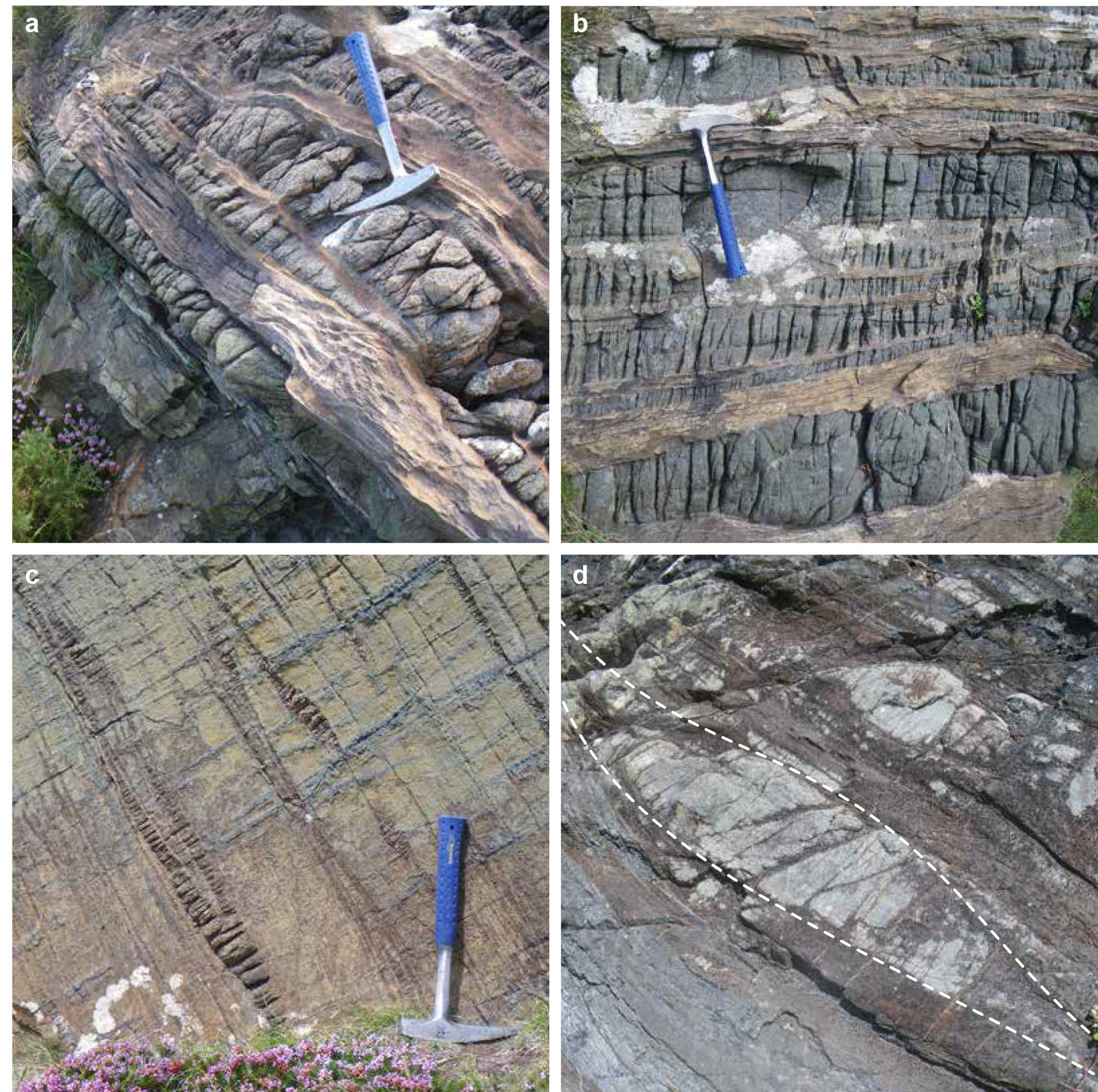
Figure 2. Typical exposures of Cabo Ortegal pyroxenites and dunites (a and b); individual pyroxenite layers may reach up to 3m thickness. Boudinaged pyroxenite layers in harzburgites bear witness to deformation under high-temperature conditions (c). The characteristic sigmoid shape of sheath folds developed from high shear strain of pyroxenites (d) and peridotites during delamination and subduction.
The Herbeira massif thus may represent the first recognised piece of delaminated arc root, which originated as primitive boninitic to picritic cumulates in a peridotite matrix. It may offer insights into the problem of the “andesitic” continental crust.
This project is part of CCFS themes 2 and 3, Earth‘s Evolution and Earth Today, and contributes to understanding Earth‘s Architecture and Fluid Fluxes.
Contacts: Romain Tilhac, Hadrien Henry, Sue O‘Reilly, Bill Griffin, Norman Pearson, Michel Grégoire, Georges Ceuleneer (Géosciences Environnement Toulouse, GET, France)
Funded by: Flagship Program 1, iMQRES scholarships, EPS postgraduate funds, CNRS funds (M. Grégoire, G. Ceuleneer). Two co-tutelle programs between Macquarie and Paul Sabatier University, Toulouse, France have been established for the study of the Cabo Ortegal Complex.
Extreme lithium isotopic fractionation in three zircon standards (Plešovice, Qinghu and Temora)
Li isotopes in zircon are a new isotopic tracer for studying the origin and genesis of granitoid rocks and their implications for the early Earth evolution. However, there is still controversy as to whether Li isotopes in zircon retain their magmatic signatures or are modified by later processes.
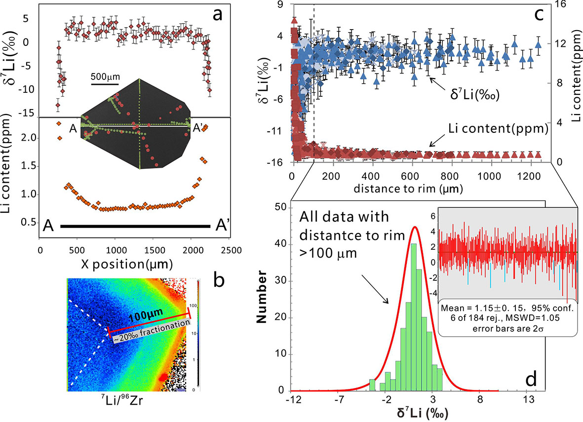
Figure 1. a) Trace outlines on the CL image of Plešovice-R show the position of the Li isotopic and [Li] measurements by SIMS; b) The ion image of the variation of Li and Y content (bright colours = higher concentration); c) δ7Li and [Li] vs relative distance to the rim; d) Probability density plot and weighted average of analysed spots more than 100 μm from the rim.
To understand Li behaviour in zircons, we have analysed Li isotopes and abundance in crystals of three zircon standards (Plešovice, Qinghu and Temora) commonly used for microbeam analysis of U-Pb age and O-Hf isotopes. We have also mapped Li concentration ([Li]) (image: 150 μm × 150 μm) on selected grains, using a Cameca 1280HR Secondary Ion Mass Spectrometer (SIMS). All zircon grains have a rim 5-20 μm wide in which [Li] is 5 to 20 times higher than the in core. Large isotopic fractionations (up to ~20‰) are observed in thin zircon rims (~50 μm) of single grains. The measured δ7Li values range from -14.3 to +3.7‰ for Plešovice, -22.8 to 1.4‰ for Qinghu and -4.1 to 16.1‰ for the Temora zircon. The [Li] and δ7Li are highly variable at the rims but relatively homogenous in the cores of the grains. From zircon rim to core, the [Li] decreases rapidly, while the δ7Li increases, suggesting that the large isotopic variation of Li in zircons could be caused by diffusion. Our data demonstrate that areas with homogeneous δ7Li in the cores of large zircon grains can retain the pristine isotopic signatures of the magmas, while analysis of bulk-rocks and/or mineral separates might produce false data: values representing mixing of rims and cores.
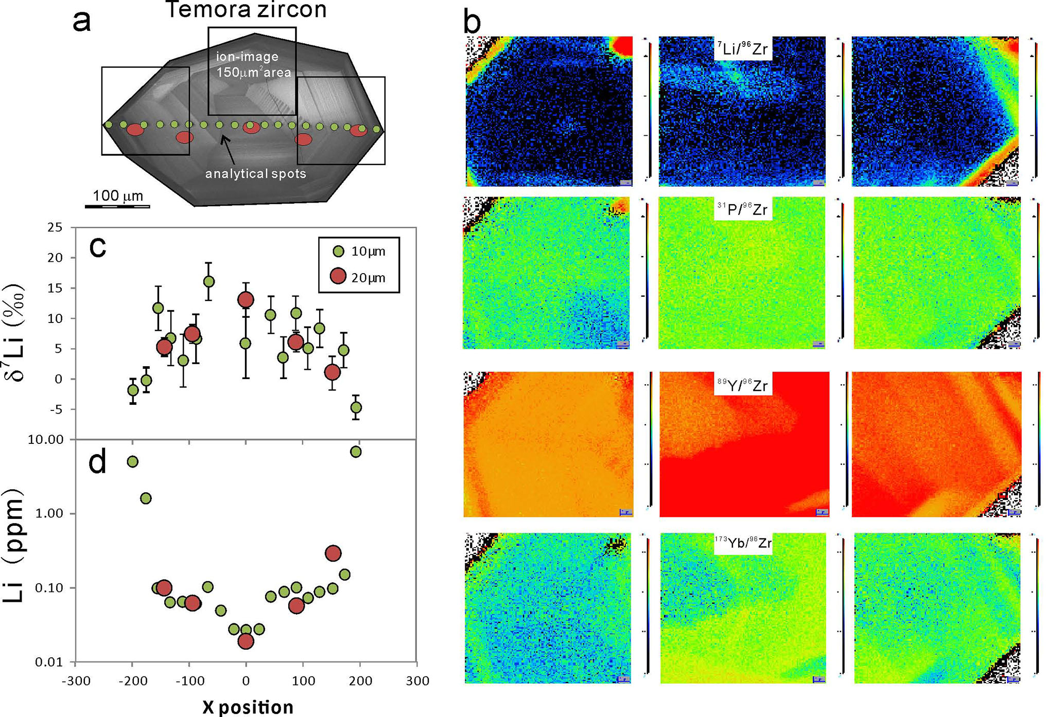
Figure 2. a) The CL image and analytical spots on the Temora zircon; b) ion images of Li, P, Y, and Yb; c) δ7Li profile through zircon; d) [Li] profile through zircon.
This project is part of CCFS Theme 2, Earth‘s Evolution, and contributes to understanding Earth‘s Architecture
Contacts: Yu-Ya Gao, Xian-Hua Li, Bill Griffin, Yan-Jie Tang, Norman Pearson, Yu Liu, Mei-Fei Chu, Qiu-Li Li, Guo-Qiang Tang, Sue O‘Reilly
Funded by: National Natural Science Foundation of China, the Ministry of Science and Technology, MUIPRS, CCFS Flagship Program 1
Bridging the gap: using numerical modelling to better understand CO2 transfer in subduction zones
When it comes to the chemical evolution of Earth, two volatile components stand out as the most geologically significant: water (H2O) and carbon dioxide (CO2). These volatiles play a crucial role in every facet of life. Both are key building blocks for organic life on Earth and H2O has a profound impact on plate tectonics, where it is largely responsible for its mobility.
Volatile recycling in subduction zones, especially of H2O, greatly affects the physicochemical properties of the overlying mantle (composed mostly of peridotite). As the mantle wedge hydrates, it loses its strength, density and viscosity, and it melts at lower temperatures, as a consequence of metasomatisation. On the other hand, the physicochemical effects of metasomatisation with a carbonic fluid are more subtle and enigmatic. Like H2O, CO2 decreases the melting temperature of peridotite. Interestingly, carbonate-rich melts are extremely mobile agents that can extract highly incompatible, heat producing elements (U, Th, and K). This can influence the long-term thermal budget of the mantle, and lead to thermal anomalies at different levels of the mantle. Carbon is also economically significant, important in its elemental form as either diamond or graphite. Lastly, the global carbon cycle and the habitability of our planet depend on the stability of carbon and its residence time in the mantle, the recycling efficiency in subduction zones, and rates of magmatic degassing.
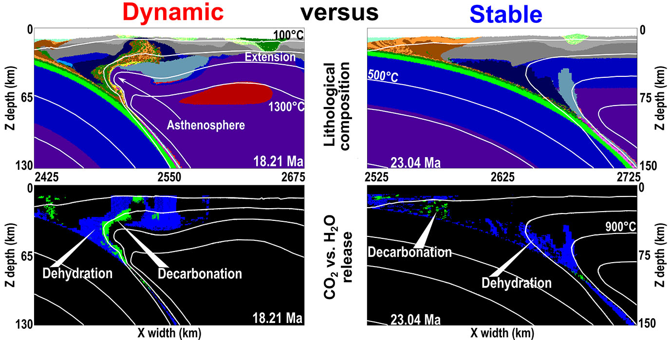
Figure 1. Image showing a comparison of a dynamic subduction zone with a stable subduction zone. In the stable subduction zone, there is neither extension nor sedimentary diapirism. In the dynamic subduction zone, the hot asthenosphere and low pressures result in the release of CO2. Green and blue colours represent decarbonation and dehydration respectively. Fluids released are able to interact with and metasomatise the overlying lithospheric mantle
Recently, much effort has been put into understanding the global carbon budget at depths greater than our atmosphere and the crust. Despite these efforts, estimates of carbon concentrations remain largely unconstrained. Experimental and thermodynamic models have been constructed to establish the amount of CO2 recycled within subduction zones, but these have failed to give a conclusive number.
In this work, for the first time, a binary H2O-CO2 fluid has been coupled to a state-of-the-art geodynamic numerical modelling code (I2VIS). This allows us to study how dynamic effects, such as slab roll-back or sedimentary diapirism, lead to decarbonation, carbon recycling, and CO2 metasomatism in a subduction zone.
This research bridges the dynamics gap, between static thermodynamic modelling and petrological experiments. We accomplished this by testing a wide range of subduction conditions to determine the key parameters that result in decarbonation in the context of a modern subduction zone. The results show that for different subduction regimes, distinctive degassing patterns are observed in time and space. For example, during stable subduction (Fig. 1) little, concentrated CO2 release is observed, while in more dynamic models, decarbonation is more widely spread through the length of the subducting slab; this difference is a result of non-linear effects that are only seen during 3D and 4D modelling (x,y,z directions and time). We look to further extending our methods beyond decarbonation and to incorporate melting of subducted carbonated components to better understand recycling beyond subarc depths.
This project is part of CCFS themes 2 and 3, Earth‘s Evolution and Earth Today, and contributes to understanding Earth‘s Architecture and Fluid Fluxes.
Contacts: Chris Gonzalez, Weronika Gorczyk
Funded by: ARC LP (LP100200785), UWA SIRF scholarship
In the deep between the WAC and the SAC
One way of determining the affinity of blocks of crust is to compare their Hf isotopic signatures. Flagship Program 7 aims to generate Lu-Hf isotopic data on previously dated zircon samples, and integrate this with geological, geochemical, and geophysical datasets of the Geological Survey of Western Australia. The research is focused in ‘greenfields‘ areas where little information presently exists. More than 9000 zircons, from 500 samples, have been analysed during the life of the project. Zircon samples have been selected from dated material in igneous, metamorphic, and sedimentary rocks of the Pilbara Craton, the Eastern Goldfields Superterrane and Murchison Domain of the Yilgarn Craton, the Albany-Fraser Orogen, the Musgrave Province, the Kimberley and Amadeus Basins, the Rudall Province, the Gascoyne Complex, and basement rocks beneath the Eucla Basin. This integrated approach, in which isotopic constraints are viewed in the context of geochemical information, geological mapping, and geophysical datasets has significantly enhanced our understanding of the geodynamics of Western Australia and provided a powerful new dataset to test models of tectonic evolution of the region. This work closely aligns with the UNCOVER initiative that seeks to provide an innovative, structured and nationally coordinated strategic plan to understand the deep geology of Australia, and thus bring competitive advantage to mineral exploration in Australia.
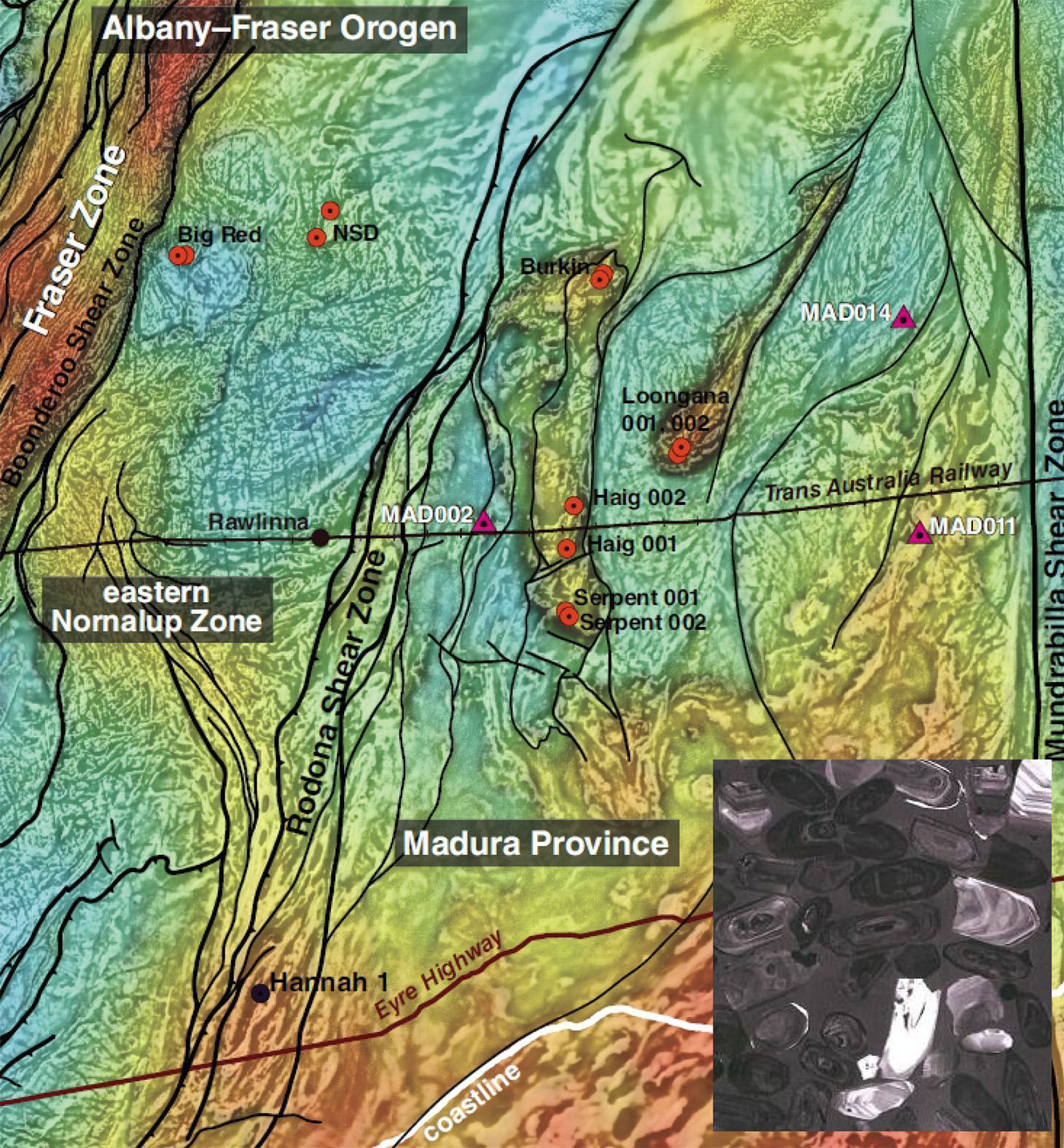
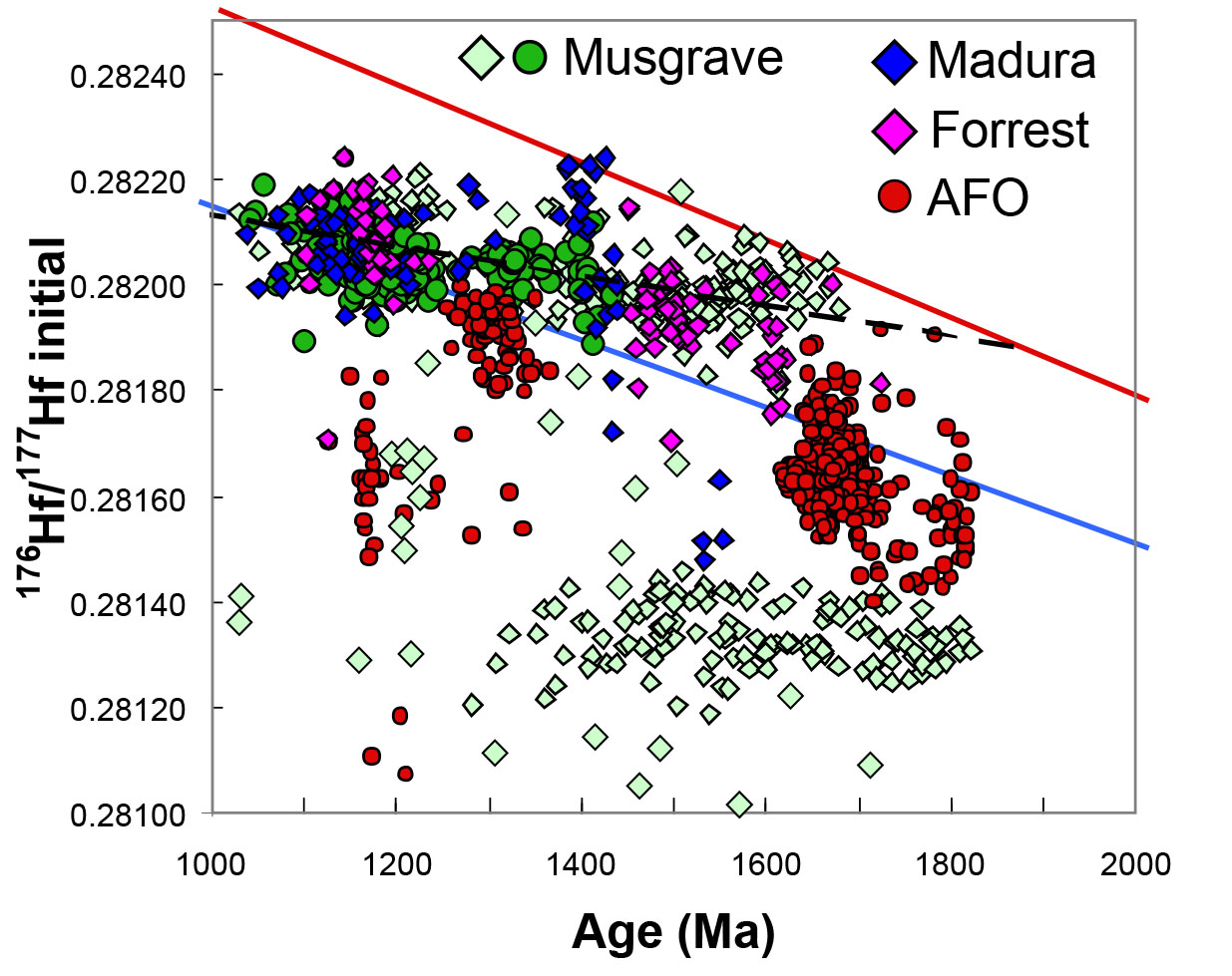
Figure 1. Map of drillhole locations in the eastern Albany-Fraser Orogen and Eucla basement superimposed on a gravity image with geology overlay. Stratigraphic drillholes (triangles) and other drillholes (circles) show the location of material from which Hf isotopes have been acquired. Inset: lower right, CL image of example zircon grains from granite within drillhole sample. Upper right; Hf isotopic evolution plot showing the change in isotopic signature through time and the projection back to a common mix of sources.
The Precambrian crystalline basement beneath the Eucla Basin represents a frontier ‘greenfields‘ region; very little is known about its age, composition, and geodynamic evolution. Recently the GSWA Exploration Incentive Scheme co-funded drilling of stratigraphic drill holes that have provided a unique sample set on which a range of cutting edge isotopic techniques has been applied in an effort to reveal its geological evolution and enhance its exploration potential. The exposed mineralised Gawler and Yilgarn cratons are separated by nearly one thousand kilometres of basement that represents a large prospective mineral province, but this region is buried beneath sedimentary basins formed during the development of Australia‘s southern margin. The mineral potential of this zone between the West Australian Craton (WAC) and the South Australian Craton (SAC) is demonstrated by recent onshore exploration success in both the Tropicana Zone (gold) and the Fraser Zone (nickel). Both these deposits lie in the Albany-Fraser Orogen, which reflects Proterozoic modification of the Yilgarn Craton. The basement substrate that lies further east between the exposed WAC and the SAC remains comparatively unknown.
Isotope geology is perhaps uniquely placed to see through overprinting events to expose both the timing and nature of early crustal formation processes. The Madura Province, the area of basement bounded by the Rodona Shear Zone and the Mundrabilla Shear Zone, lies adjacent to the Albany-Fraser Orogen but preserves a geological history startlingly different from its western neighbor. The Madura Province records two broad phases of magmatic activity. Zircon geochronology from intrusives (gabbros and granites) constrains one phase to 1411-1389 million years, whereas younger granites and gabbros have crystallisation ages of 1180-1125 million years.
Zircon crystals from all these magmatic rocks cluster along an apparent evolution array intersecting the depleted mantle at 1900-2000 million years ago. This suggests that these rocks all reflect dominant generation from a new piece of crust formed at this time. Scatter in this apparent evolution array is clear evidence of new mantle input during the initial phase of 1411-1389 million year magmatism. The isotopic signature of this region is similar to that of intrusive rocks of the Musgrave Province in Central Australia. Although the age of magmatic crystallisation may be different, the timing of initial formation of crust is similar between the two provinces. In detail we interpret the 1900-2000 million year crustal-formation array to reflect a complex mix of oceanic magma sources with at least three components, including generation of new crust at 1900 million years and 1600-1200 million years, which also involved older Archean material. Such petrogenetic processes match aspects of oceanic arc magmatism and demonstrate that the Rodona Shear Zone was a fundamental suture separating reworked rocks of Yilgarn heritage from a new substrate of oceanic affinity lying between the older crustal blocks. These isotopic data, along with new geochemistry radically refine our understanding of the substrate between the Yilgarn and Gawler cratons, and suggest it reflects Proterozoic oceanic crust.
This project is part of CCFS themes 1 and 2, Early Earth and Earth‘s Evolution, and contributes to understanding Earth‘s Architecture.
Contacts: Chris Kirkland, Michael Wingate, Yongjun Lu, Elena Belousova, Catherine Spaggiari, Hugh Smithies, Ed Saunders, Rosanna, Murphy, Geological Survey of Western Australia
Funded by: Geological Survey of Western Australia
The hidden Archaean of Volgo-Uralia: a zircon tale
The amount of preserved Archean lithosphere and its global distribution are important for reconstructing Early Earth and to assess its subsequent evolution. However, only ca 20% of the presently remaining Archean crust is exposed at Earth‘s surface; the rest is hidden beneath polar ice sheets and the sedimentary cover of cratons, or forms minor fragments within Proterozoic and Phanerozoic orogenic belts.
The protocontinent Volgo-Uralia (Fig. 1), which constitutes one-fourth of the East European Craton (EEC, “Baltica”), is covered entirely by thick sedimentary deposits. From geophysical studies and the examination of thousands of drillcores, the basement of Volgo-Uralia has been recognised as a vast high-grade terrain with a complex crustal history extending from the Paleoarchean to the Paleoproterozoic.
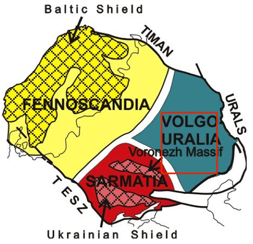
Figure 1. The three-segment subdivision of the EEC lithosphere. The red frame outlines the best-investigated part of Volgo-Uralia.
Our recent studies in Volgo-Uralia have been focused on looking for major events of the Archean crustal evolution employing Sm-Nd whole-rock analysis as well as the ion probe U-Th-Pb (SIMS) and Lu-Hf (LA-ICPMS) to analyse zircons. Particular attention was devoted to the widespread charnockitic rocks, which form large intrusions and contain zircon crystals with notably complex growth histories.
The zircons from one sample, an enderbite, have prismatic magmatic cores up to 2 mm across with oscillatory zoning, which enclose a few smaller zircon grains of an earlier generation (Fig. 2). The cores are surrounded by CL black-and-bright paired bands of curved metamorphic rims. The cores were notably fractured and fragmented prior to the metamorphic event.
The application of several methods of study (U-Pb SIMS/SHRIMP, ICPMS+TE, O- and Hf-isotopes in zircon) revealed (Fig. 3) that:
• The crystallisation age of the magmatic cores is between 3140±7 Ma (SHRIMP) and 3127±46 Ma (LA-ICPMS), while the metamorphic CL-bright rims formed atca 1950 Ma (Fig. 3a and b). Intermediate ages are interpreted as resulting from various degrees of Pb loss caused by high-grade metamorphism.
• The metamorphic recrystallisation of the primary magmatic zircon correlates with depletion in REE, Pb and U which has been observed consistently in each analysed core-rim pair. Characteristically, the metamorphic rims are enriched in P and Hf. Variations of trace elements in the magmatic cores control those in the outermost metamorphic rims.
• The Hf-isotope compositions of the magmatic cores (-3 to -9 εHf) and metamorphic rims (-14 to -28 εHf), and their similar crustal model ages from 3.42 to 3.86 Ga, that the charnockitic magmas were derived by remelting of Eo- to Paleoarchean crust and very little, if any, juvenile material was added during the metamorphic event at ca 1950 Ma (Fig. 3c).
• No differences in O-isotopic composition have been detected between the cores and the rims; the δ18O values vary from ca. 5 to 6.5 (Fig. 2), indicating that the Eo- to Paleoarchean crustal source of the magmas was originally mantle-derived.
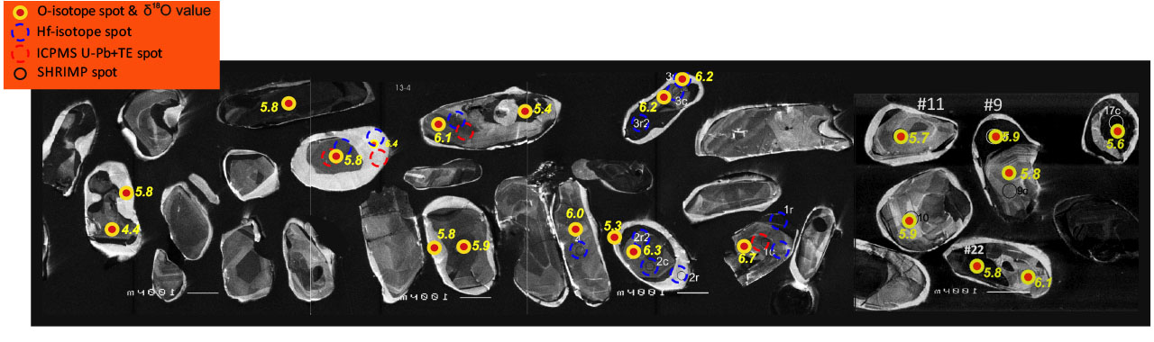
Figure 2. CL images of zircon from the studied enderbite. Gorbatovskaya 51 drill core (2896-2914 m depth), southern Volgo-Uralia.
From these results we conclude that the Mesoarchean (ca 3.1 Ga) granulitic crust in southern Volgo-Uralia was formed by the reworking of Eo- to Paleoarchean crust. Hf model crustal ages of up to 3.9 Ga found in this region as well as in central Volgo-Uralia suggest that Eo- to Paleoarchean continental crust was widespread throughout Volgo-Uralia. A back-arc setting along an active continental margin may explain the high-T, “dry and ferroan” magmatism of the studied charnockitoids. An alternative interpretation may be that deep mantle-plume activity at 3.1 Ga caused mantle underplating, extension of the Palaeoarchean crust and high-T magmatism.
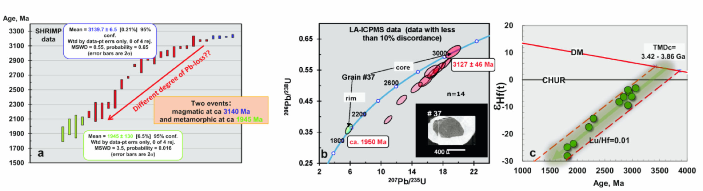
Figure 3. Results of the zircon studies.
This project is part of CCFS Theme 1, Early Earth, and contributes to understanding Earth‘s Architecture.
Contacts: Svetlana Bogdanova (Lund University), Elena Belousova (CCFS)
Funded by: Belousova ARC Future Fellowship
Crustal volcanic plumbing systems follow lithospheric boundaries in the Newer Volcanics Province, SE Australia
Intraplate volcanism is a widespread phenomenon, which is generally regarded to be independent of plate tectonics due to its distance from plate boundaries. The Newer Volcanics Province (NVP) is the most recently active intraplate volcanism on the Australian continent. It includes more than 700 eruptions, with the earliest ~4 million years ago and the latest <5000 years ago. The erupted basaltic magmas cover a region more than 19,000 km2, with an average thickness of less than 60 m. The origins of this intraplate-setting volcanism have drawn considerable attention from geoscientists. The latest research in the region suggests the NVP may originate from combined effects of localised mantle flow and shear flow, which are caused by the Australian plate‘s drift across a significant lithospheric step; while a nearby hotspot track - presumably fuelled by a plume - may have initiated the volcanism at ~4.5 Ma. However, important questions regarding how the magmas were stored and how they migrated through the crust to the surface remain unanswered, mainly due to the poor constraints on the crustal component of the NVP magmatic system.
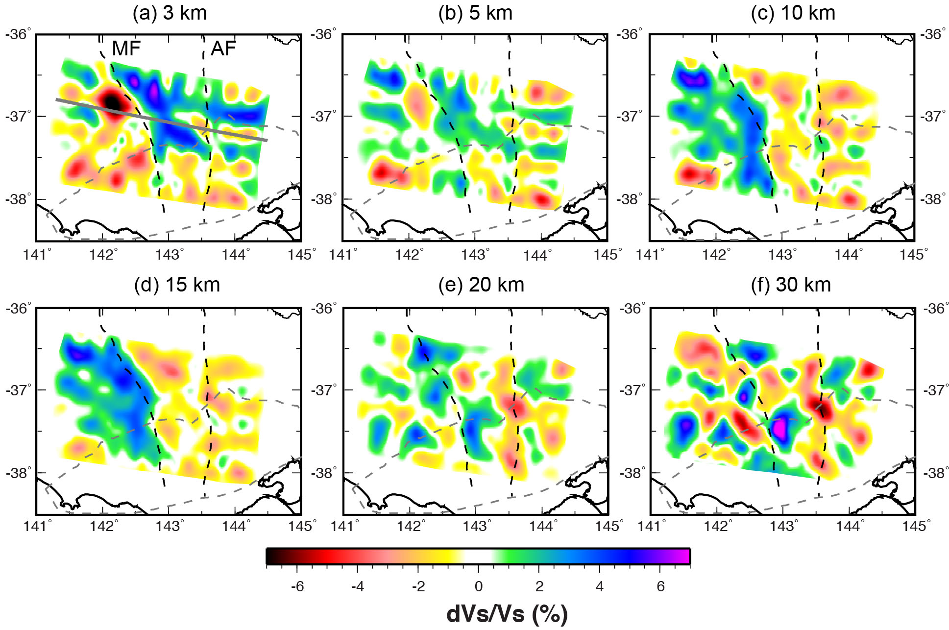
Figure 1. Vsv maps at depths of (a) 3, (b) 5, (c) 10, (d) 15, (e) 20 and (f) 30 km. All depths are relative to sea level. The solid grey line in figure (a) shows the profile location for Figure 2. Abbreviations: MF-Moyston Fault; AF-Avoca Fault.
In this study, we use ambient noise tomography and probabilistic inversion methods to construct the first local 3D crustal images of the NVP region (Fig. 1) with a general resolution of ~35 km. The images display distinct velocity features near the eastern and western margins of the NVP through the entire crust. This suggests the existence of a lithosphere-scale plumbing system for the migration of melt, associated with the boundary between the Delamerian Orogen and the Lachlan Orogen, which underlies the NVP. In particular, exceptionally high velocities are observed in the middle crust of the Delamerian Orogen, which are best explained by buried magmatic arcs, resulting from subduction-accretion processes during the Delamerian Orogeny. The model also images small localised velocity reductions in the lower crust in the region where the two distinct lithospheric units meet. The low-velocity zone is spatially correlated with the top of a prominent lithosphere-scale low-resistivity zone, which we interpret to represent intruded magmatic sills with small proportions of melts. The minor volumes of erupted magmas and the small magmatic intrusion seen in the current lower crust indicate a much smaller magmatic plumbing system beneath the NVP (Fig. 2) than that of Yellowstone, which has a mantle-plume origin.
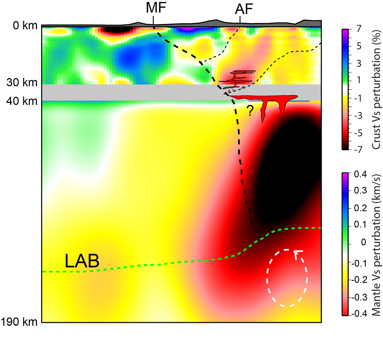
Figure 2. A cartoon to illustrate the accumulated magmatic intrusion in the lower crust beneath the NVP and its connection with the deep lithosphere. The crustal Vs perturbation is relative to the regional average from this study (0-30 km; two times exaggeration relative to the mantle part); while the mantle Vs perturbation is relative to the ak135 model [Kennett et al., 1995] in km/s from Rawlinson et al., [2016] (40-190 km). The white circle illustrates the edge-driven convection from the geodynamic model of D. Rhodri Davies and Rawlinson [2014]. The shaded area on the top of the section represents the real topography, and the depth of the LAB (Lithosphere-Asthenosphere boundary) is an approximation illustration based on the study of D. Rhodri Davies and Rawlinson [2014]. Abbreviations: MF-Moyston Fault; AF-Avoca Fault.
This project is part of CCFS Theme 3, Earth Today, and contributes to understanding Earth‘s Architecture and Fluid Fluxes.
Contacts: Chengxin Jiang, Yingjie Yang, Nick Rawlinson
Funded by: ARC Discovery Project, Yang ARC Future Fellowship, MQRES scholarship
Trace Elements in Zircon, and the Oxidation State of Magmas
Many elements in silicate melts and crystalline rocks vary in ionic electric charge (also called ionic “valence” or “oxidation state”), depending chiefly on availability of oxygen as an electron acceptor; its availability is conventionally represented as “oxygen fugacity”, ƒO2. Such elements include iron as Fe2+ and Fe3+, sulfur as S2-, S4+, and S6+, cerium as Ce3+ and Ce4+, europium as Eu2+ and Eu3+, uranium as U4+, U5+, and U6+, tin as Sn2+ and Sn4+, vanadium as V3+, V4+, and V5+, and molybdenum as Mo4+ and Mo6+. Whether or not a magma can produce an ore deposit of V, Sn, Mo, or Cu depends substantially on the valence of those elements in the magma. Major controversies surround the oxidation state of the early Earth‘s upper mantle and surface 4.5-2.3 billion years ago, and to what degree the oxidation state of Earth‘s mantle has been affected by cycling of materials from the surface into the planetary interior over the past 2.3 billion years, as Earth‘s surface became more oxidised due to production of oxygen by photosynthetic microbes.
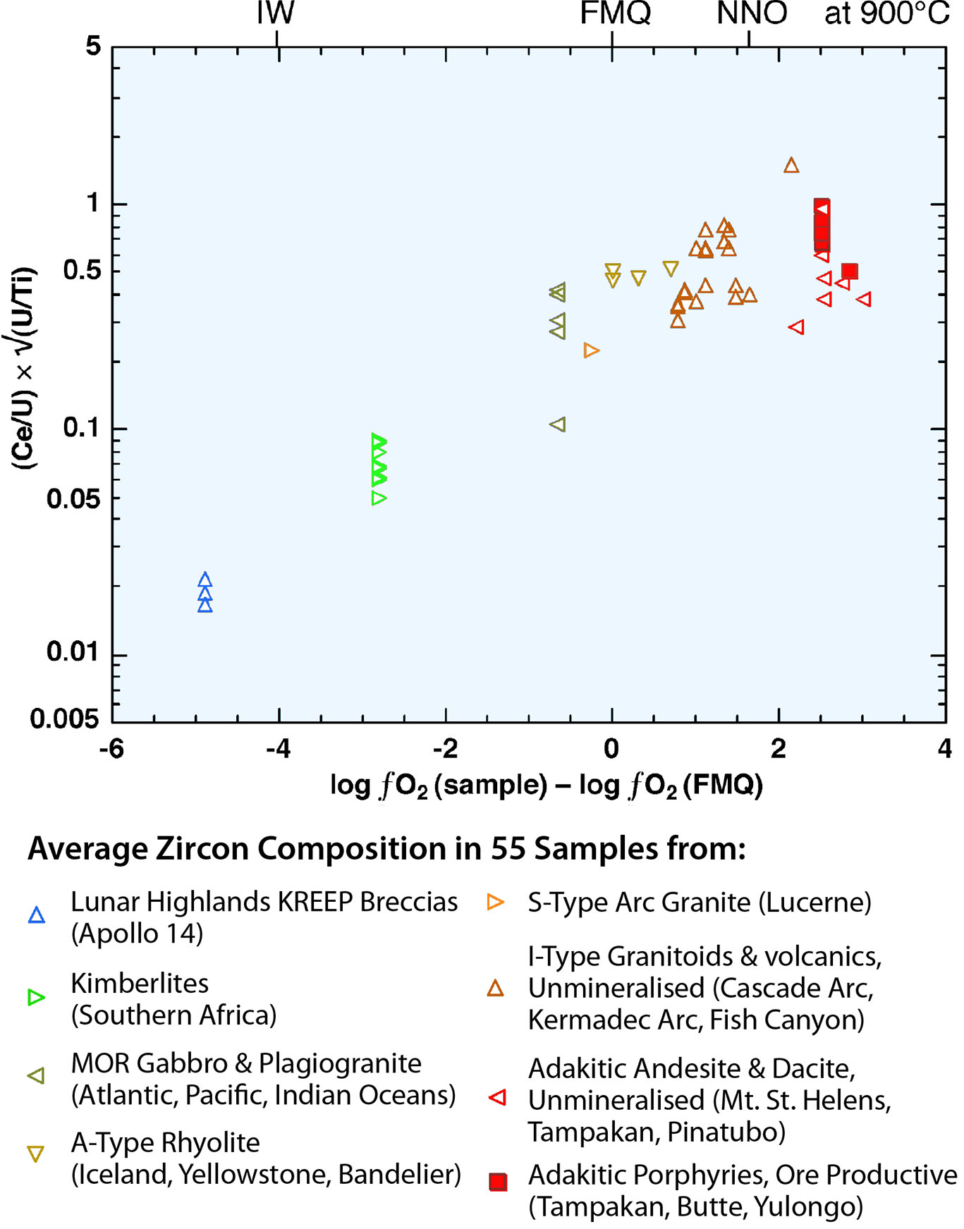
Figure 1. The average composition of several zircons in each of 55 samples is plotted against apparent oxidation state of the silicate melt from which the zircon crystallised. The abscissa variable is log units of oxygen fugacity above or below that of the reference mineral assemblage fayalite+magnetite+quartz, as given in publications that reported values of the oxidation state in the host rocks of the analysed zircons. Solid red symbols represent samples from igneous bodies related to copper ore deposits.
Electron transfer among elements is fast, so all elemental oxidation/reduction couples in silicate melts are instantaneously interactive; therefore, a measure of the valence ratio of one element is, in principle, a constraint on the valence ratio of every other element. Zircon, Zr4+Si4+O4, is a common minor mineral in igneous rocks and preserves a record of the oxidation state of its parent silicate melt and of the melt‘s source because (1) it takes in trace amounts of other elements of variable electric charge that substitute for Zr4+ and Si4+, and (2) it is extremely resistant to chemical modification after crystallisation, so its record of oxidation state can be preserved for billions of years of deep burial at sub-magmatic temperatures. Over the past decade, scores of published papers have reported estimates of the relative oxidation state of magmas using the ratio Ce4+/Ce3+ in zircon. Experimental studies demonstrate that Ce4+/Ce3+ in silicate melts and zircon vary with magma oxidation state, but the ratio in zircon is even more sensitive to variation of temperature, because Ce3+ is 18% larger than Ce4+, and 36% larger than Zr4+, so substitution of Ce3+ represents a misfit in both size and charge. This requires coupled substitution of another misfit ion, usually either phosphorus P5+ for Si4+ or OH1- for O2-. Therefore, the Ce4+/Ce3+ ratio in zircon is extremely sensitive to thermal contraction of the zircon crystal lattice, and the temperature dependence usually overwhelms the ƒO2 signal being sought. We find that in nearly all publications in which zircon Ce4+/Ce3+ was inferred to represent magmatic oxidation state, the variations in Ce4+/Ce3+ were actually due almost entirely to variations in temperature.
To formulate a zircon sensor of the oxidation state of the parent magma that is relatively insensitive to temperature variation, the sensor ions need to have the same ionic charge and nearly the same size. The ratio Ce4+/U4+ in zircon fits those requirements. However, the zircon inherits a distorted version of this ratio from its parent melt, biased by partition coefficients. As the parent melt crystallises, its Ce4+/U4+ ratio decreases due to selective removal of some Ce4+ by other minerals that start crystallising before zircon. So the zircon indicator of magmatic oxidation state needs to account for the stage of chemical evolution of the parent magma. The ratio U/Ti in zircon works well as a qualitative indicator of the stage of chemical evolution of the parent magma. Figure 1 illustrates the potential of our new indicator of magmatic oxidation state, using our microbeam chemical analyses of zircons in eight igneous suites and many compiled from published literature. For each of these igneous suites, independent estimates of magmatic oxygen fugacity, ƒO2, are available.
This study is an outcome from the ongoing Flagship Program 2.

This project is part of CCFS Themes 2 and 3, Earth‘s Evolution and Earth Today and contributes to understanding Fluid Fluxes.
Contacts: Robert Loucks, Marco Fiorentini, Yongjun Lu
Funded by: CCFS Flagship Program 2
Resolving the controversy of Earth‘s oldest fossils
A few 10 km outside Marble Bar in the Pilbara region of Western Australia lies one of the more famous sites for scientific research in Australia. Around a quarter of a century ago, UCLA palaeontologist JW Schopf discovered tiny filaments preserved within a ~3.5 Ga silica-rich rock, the so-called Apex chert. These were interpreted as the fossilised remains of primitive filamentous bacteria and thus thought to constitute the earliest known evidence for life on Earth.
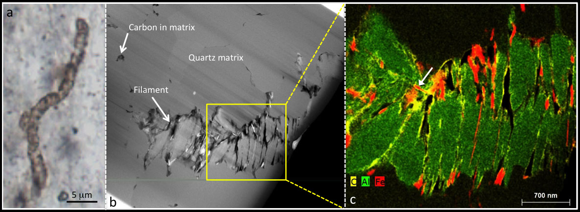
Figure 1. a) Typical filament from the 3.46 Ga Apex chert viewed using light microscopy. b) Transmission electron microscopy image of a filament from the Apex chert. c) False colour three-element overlay map of area boxed in (b). The filament comprises stacks of sheet-like phyllosilicate grains (green) with carbon (yellow) and iron (red) interleaved between some of the sheets. This distribution of phases is incompatible with a biological origin for the filament. In places, carbon completely coats the iron phase (arrow) suggesting carbon was the last phase to become associated with the filaments.
With the technology available to researchers at that time this was a reasonable interpretation. The sizes of the filaments (mostly 1-20 μm in diameter) were comparable to known filamentous bacteria and they had an internal structure that resembled multiple cells joined in chains.
During the following decade these filaments became embedded in both the textbook and popular science literature as ‘Earth‘s oldest microfossils‘ and were also heralded as the standard against which other possible signs of ancient (or even extra-terrestrial) microbes should be judged.
Everything changed in 2002 when a team led by Oxford palaeobiologist Martin Brasier questioned the authenticity of the microfossils. Brasier and colleagues had re-interpreted the geological setting of the filaments, demonstrating that they were trapped in rocks that formed at high temperatures during volcanic activity, casting doubt on Schopf‘s initial interpretation.
Re-examination of the filaments under the microscope revealed that some appeared to branch and others followed the edges of mineral crystals. These new findings led the Brasier group to propose that the filaments were not microfossils, but merely bits of carbon, arranged in roughly filamentous patterns around crystal boundaries, probably formed by hot fluids.
In the ensuing decade or so the ‘Apex microfossil debate‘ has been intense. Although it is now accepted that the geological setting probably is hydrothermal, this has not diminished the Schopf group‘s belief in the authenticity of the microfossils. They now suggest that the filaments are fossils of heat-loving (thermophilic) bacteria, similar to those found around deep-sea hydrothermal vents today. On the other side of the debate, the Brasier group presented more detailed geological and microscopic analysis consistent with the filaments being non-biological artefacts. A scientific stalemate had been reached.
New work at CCFS led by ARC Future Fellow David Wacey in collaboration with the late Professor Brasier has finally ended the stalemate. Wacey and colleagues used high spatial resolution electron microscopy techniques to investigate the detailed structure and chemical composition of the filaments. This research, published in two parts in Proceedings of the National Academy of Sciences (CCFS Publication #528) and Gondwana Research (CCFS Publication #663) has confirmed that the Apex filaments are not microfossils, but instead are mineral artefacts, comprising stacks of silicate grains onto which later carbon was adsorbed.
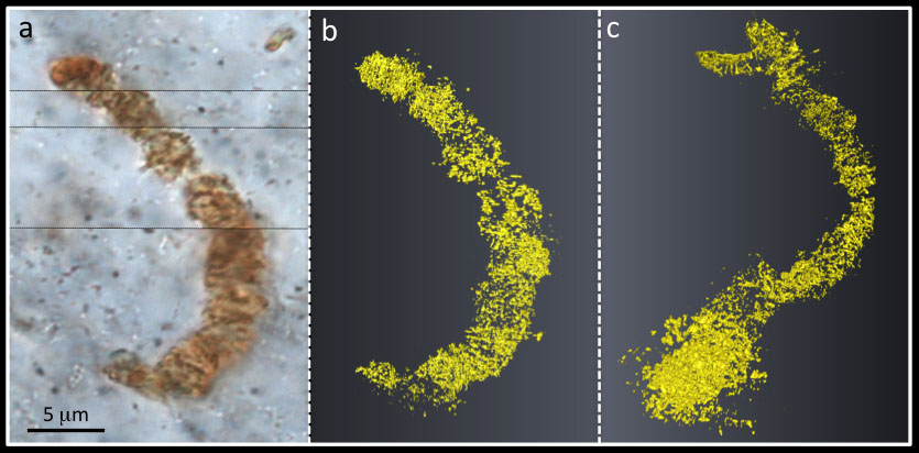
Figure 2. 3D reconstruction of an Apex filament. a) Transmitted light photomicrograph of chosen filament. b) 3D visualisation of carbon from nano-tomography images through the filament, shown in the same orientation as (a). c) 3D model rotated to show small branch extending down below the main body of the filament, not seen in (a-b), and incompatible with a primitive bacterial morphology.
The new data provide a picture of the morphology and chemistry of the filaments at a spatial scale up to one hundred times better than previous studies. At this scale it becomes apparent that the filaments are made of hundreds of plate-like grains of a potassium and barium rich silicate mineral, similar in appearance to common mica. Although carbon is present in the filaments, its distribution is incompatible with any known biological morphology (Figs. 1 and 2).
Today mica-like minerals are used to clean up oil spills due to their very high capacity to adsorb hydrocarbons, and the carbon in the Apex filaments probably was arranged by a similar process. While the lower-resolution techniques previously employed allowed a potential biological interpretation, the new high-resolution images show that the arrangement and distribution of the carbon within the minerals does not support the biological hypothesis.
Previously reported ‘cellular compartments‘ actually have very inconsistent lengths, and length/width ratios that match crystal growth patterns but are unlike any known microbial cells. The carbon is found to have entered the filaments after the formation of the surrounding minerals, again inconsistent with it being the in situ remains of bacteria (Fig. 1).
The field of early life research is fraught with difficulty. Data initially interpreted as biological in origin is often reinterpreted at a later date as having a geological explanation. As new analytical techniques become available, accepted paradigms may have to be questioned.
This research does not really move the goalposts for when life first originated on Earth, since there are robust microfossils only a few million years younger than the Apex material. However, it emphasises that not everything that looks like life really is life. Perhaps most importantly it shows that microstructures that appear to tick all the boxes for biology when examined down to the micrometre scale, can fail some of these same criteria when examined at the sub-micrometre scale. This may usher in a new way of analysing possible signs of life in the future, on Earth or further afield.
This project is part of CCFS Theme 1, Early Earth, and contributes to understanding Fluid Fluxes.
Contact: David Wacey
Funded by: ARC Future Fellowship
Mingling processes in Cretaceous Angolan kimberlites
Kimberlites are volcanic rocks which are best known as potential diamond mines. Indeed, it was the deep source of the kimberlitic magmas, as well as their rapid emplacement, that turned them into targets for diamond exploration. Angola is ranked fourth in Africa in terms of kimberlite abundance, but due to its recently troubled history, very little work has been carried out to characterise kimberlites in this country. Fortunately, a collaboration between University of Barcelona, Universidade Agostinho Neto (Luanda), CATOCA Company and CCFS has given access to several kimberlites of the Lunda Norte province (NE Angola) and allowed us to characterise them.
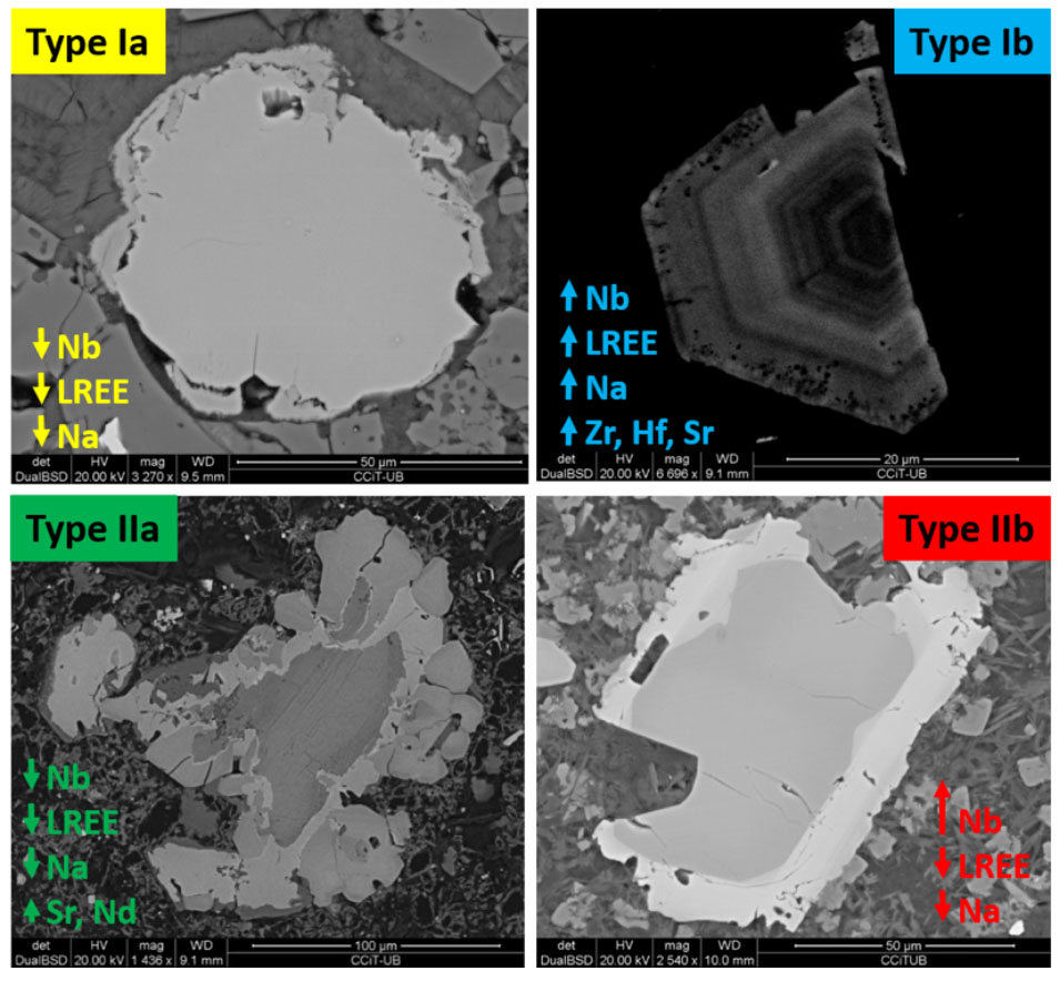
Figure 1. BSE-SEM images of the 4 textural types of perovskite found in the Angolan kimberlites, as well as their main compositional features. Primary perovskite (Type Ia) is typically unzoned, altered to TiO2 and contains no inclusions. In contrast, primary perovskite (Type Ib) is commonly euhedral, shows oscillatory zoning, has tiny inclusions near the grain boundaries and remained unaltered. Secondary perovskite usually occurs as reaction-induced rims on ilmenite and other Ti oxides (IIa), although in some cases a fourth generation of perovskite was found as thin Nb-rich overgrowths (IIb) on previously crystallised perovskite.
Kimberlites are heterogeneous rocks, with variable contents of groundmass minerals, xenocrysts and xenoliths entrained by the magmas during their ascent towards the surface. With this complex history, dating kimberlites and characterising their source is challenging. Perovskite (CaTiO3) is a ubiquitous minor phase (<10%) in kimberlites and crystallises directly from the magma. It also is relatively resistant to weathering and a main carrier of U, Th, Sr and Nd. Therefore, over the last decade, perovskite has become widely used for both age determination and characterisation of the sources of kimberlitic magmas.
This study is the first work on in situ U-Pb geochronology and Sr-Nd isotope analysis of perovskite grains from Angolan kimberlites, and is based on a detailed petrographic and chemical study of perovskite from six pipes in the Lunda Norte province.
Four types of perovskite were identified, differing in texture, major- and trace-element composition, zoning patterns, type of alteration and the presence or absence of inclusions (Fig. 1). Primary groundmass perovskite is either as anhedral, Na-, Nb- and LREE-poor perovskite (Type Ia); or euhedral, strongly zoned, Na-, Nb- and LREE-rich perovskite (Type Ib). Secondary perovskite occurs as reaction rims on ilmenite (Type IIa) or as high-Nb (up to 10.6 wt% Nb2O5) rims on primary perovskite (Type IIb). The occurrence of these four types of perovskite reflects a complex, multi-stage process that involved mingling of compositionally different melts.
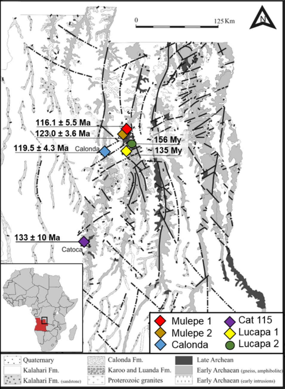
Figure 2. Location of the Angolan kimberlites studied in this work, as well as their emplacement ages.
U-Pb dating of these perovskites yielded Lower Cretaceous ages for all the studied kimberlites: Mulepe 1 (116.2 ± 6.5 Ma), Mulepe2 (123.0 ± 3.6 Ma), Calonda (119.5±4.3 Ma) and Cat115 (133± 10 Ma). Perovskite in the other two kimberlites shows higher alteration and Pb loss, and as a result only approximate ages could be obtained for the Lucapa 1 (135 Ma) and Lucapa 2 (156 Ma) kimberlites (Fig. 2).
Our results indicate that kimberlite magmatism in the Lunda Norte province (115-130 Ma) peaked around 120 Ma, coinciding with the breakup of the Gondwana supercontinent. Kimberlite emplacement was related to reactivation of NE-SW deep-seated faults (>300km deep), or cryptic continental corridors, which represent the continuation of oceanic fracture zones. The Sri and εNdi values reported in the perovskites are in good agreement with the published data for on- and off-craton South African Group I kimberlites, as well as with the petrological observations.
This project is part of CCFS Themes 2 and 3, Earth‘s Evolution and Earth Today, and contributes to understanding Earth‘s Architecture and Fluid Fluxes.
Contact: Montgarri Castillo Oliver
Funded by: SGR444 (Universitat de Barcelona), Fundació Pedro Pons (UB), CATOCA Company, CCFS
In search of high flux magma conduits with new structural mapping tools
Magmatic Ni-Cu-PGE sulfide systems account for ~60% of world Ni production and include some of the most valuable mineral camps on earth such as
Noril‘sl-Talnakh (Russia), Voisey‘s Bay (Canada), and Jinchuan (China). There is consensus that Ni-Cu-PGE sulfide deposits are associated with high-flux
magma channels that transport mantle-derived mafic and ultramafic melts into the crust. However, the mode of emplacement and self-organisation of these
magma feeder systems remain poorly understood in the context of magmatic-sulfide systems. Important questions regarding magma emplacement include:
How is magma dispersed in large mafic systems?
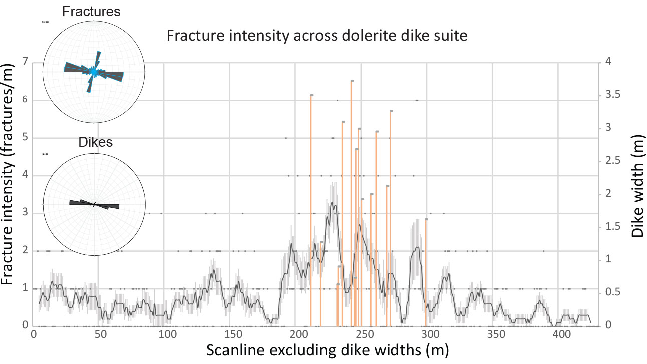
Figure 1: Moving average of fracture intensity surrounding a suite of dolerite dikes. Location of individual dikes shown in orange with dike widths on right-hand axis. Variance in average fracture intensity shown as standard error.
How do propagating intrusions interact with country rocks at micro- to macro-scales?
As a first step toward addressing these questions, we examine how magma-carrying fracture networks develop and propagate. Where data is available for intrusion-hosted Ni-Cu-PGE deposits, host rock anisotropy has been shown to be a first-order control on intrusion geometry (Saumur et al., 2015). To further investigate magma-host rock interaction an innovative technique is employed using unmanned aerial vehicles and photogrammetry to map and structurally analyse a mafic intrusion network in 3D at very high resolution (1 cm to 1 pixel, or finer). Structural data are extracted from a digitally reconstructed outcrop model using a least squares regression analysis. The accuracy of structural measurements extracted from the model has been successfully validated with conventional field measurements. This method has the advantage of rapid and accurate data collection along spatially rectified traverses, referred to as scanlines.
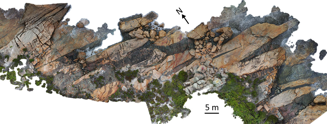
Figure 2. Rectified orthophoto of dolerite intrusion network in coastal outcrop.
The 3D mapping technique has been applied to a suite of 21 dolerite dikes emplaced in Mesoproterozoic granitic rocks along the south coast of Western Australia. The dikes are from <1 m to 5 m wide and closely spaced with a cumulative thickness of 33 m over an across-strike distance of 105 m. Dikes occupy vertical fractures that strike 075°-125°. Structural data is collected along scanlines oriented perpendicular to the mean strike direction of the dike suite. Scanline data reveal fracture intensity (number of fractures per fixed unit length) in granitic wall rocks within the dike suite to be on average 2.2 times higher than the background fracture intensity in the host rock. Though empirical data from other dike suites are not available, the fracture intensity difference is compatible with mechanical predictions of stress changes induced by propagation of an over-pressured blade-shaped intrusion (Rubin and Pollard, 1988). Such investigations of well exposed mafic intrusions are a first step toward understanding the mechanisms and dynamics of magma transport leading to the development of high-flux conduits.
This project is part of CCFS Theme 3, Earth Today, and contributes to understanding Earth‘s Architecture and Fluid Fluxes.
Contacts: Greg Dering, Marco Fiorentini
Funded by: Fiorentini ARC Future Fellowship, CSIRO Mineral Systems Flagship, CCFS Flagship Program 2
The hot-and-cold Earth system
Controversy surrounds the evolution of planet Earth through deep time, specifically whether the crust has grown uniformly over time or in pulses associated with the supercontinent cycle. New research at CCFS has set out to investigate this problem by combining global datasets of geochemical proxies that reflect both the subduction process, and the production of magmas from juvenile mantle (non-subduction-related magmatism). Proxies include oxygen isotopes and incompatible trace elements of dated magmatic rocks (subduction-recycling proxy), and Hf-isotope compositions of dated zircon crystals (mantle magmatism proxy).
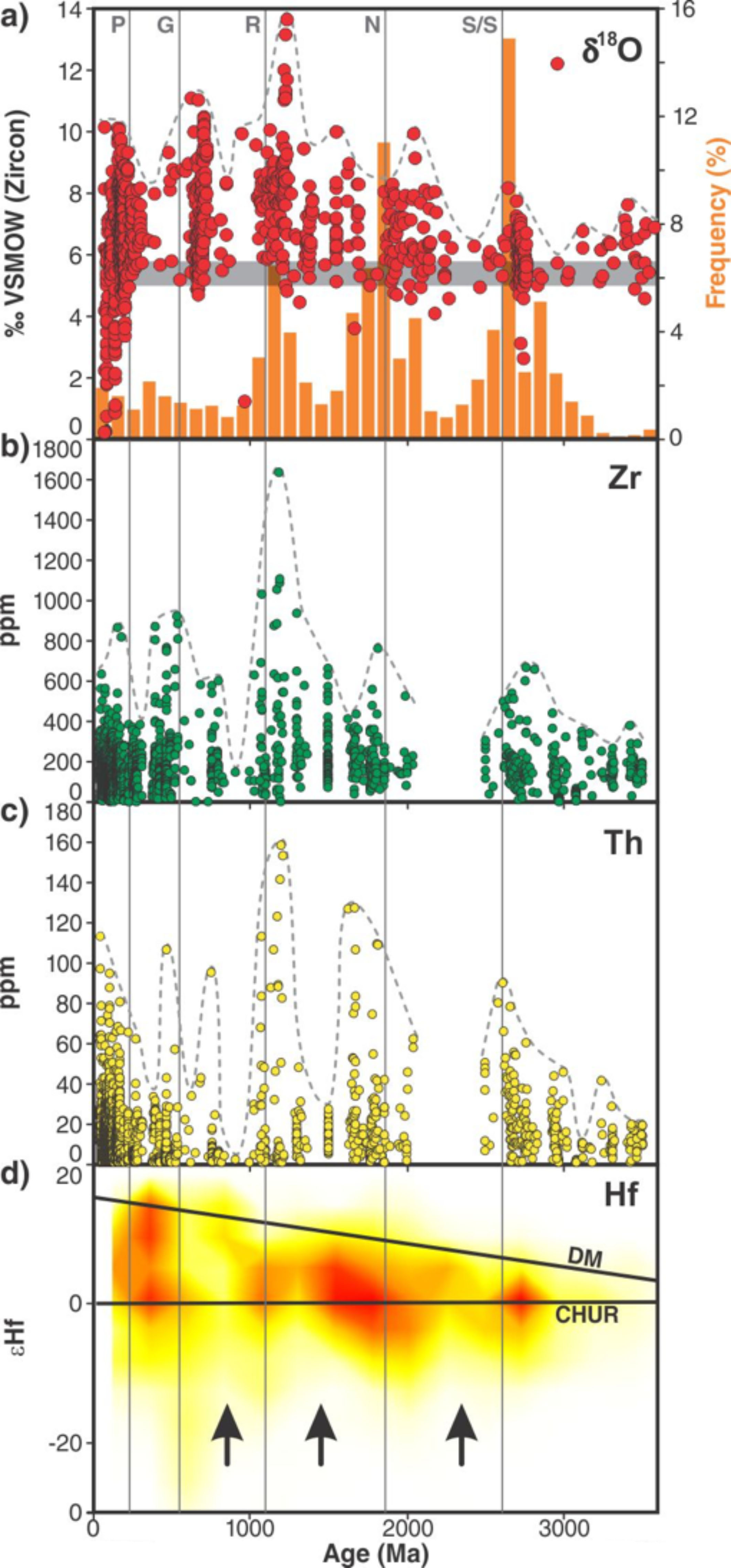
Figure 1. Evolution plots of isotopic and trace element geochemistry over time (age in millions of years (Ma)). A) δ18O(VSMOW) in zircon grains (red dots) from a global compilation plotted on a background of zircon ages of juvenile crust (data from Condie, 1998). Grey horizontal bar denotes average mantle values of oxygen isotopes in zircon (from Valley et al., 2005). B) and C) Concentrations of incompatible trace elements (Zr and Th) in dated igneous rocks from global geochemical datasets (from Van Kranendonk et al., 2015). D) Contour density plot of the number of Hf isotopic values of dated zircons from Belousova et al. (2010): CHUR = chondrite normalised uniform reservoir; DM = depleted mantle. Black arrows point to periods with minimum negative Hf isotopic values, representing pulses of minimal crustal recycling during times of supercontinent disaggregation. Red lines on the εHf vs time diagrams denote the variations in isotopic signature of crust, becoming highly negative during periods of supercontinent amalgamation as a function of increased crustal recycling, and returning to positive (juvenile) values during periods of renewed mantle magmatism accompanying supercontinent dispersals.
The results clearly show, in a statistically meaningful way, that the supercontinent cycle has been an important contributor to crustal growth since ca 3.2 billion years ago (Ga), when modern-style plate tectonics is now widely thought to have commenced (Fig. 1). More importantly, the supercontinent cycle appears to have evolved over the course of Earth history, with ever longer cycles and increasing amounts of crustal recycling up to 1 Ga, followed by decreasing amounts of crustal recycling thereafter. Periods of supercontinent formation were accompanied by widespread subduction of old, cold oceanic lithosphere and recycling of continental crust. Periods when supercontinents were amalgamated and then split apart were characterised by lower rates of crustal recycling and increased levels of juvenile mantle magmatism; the latter higher minima in Hf isotope values.
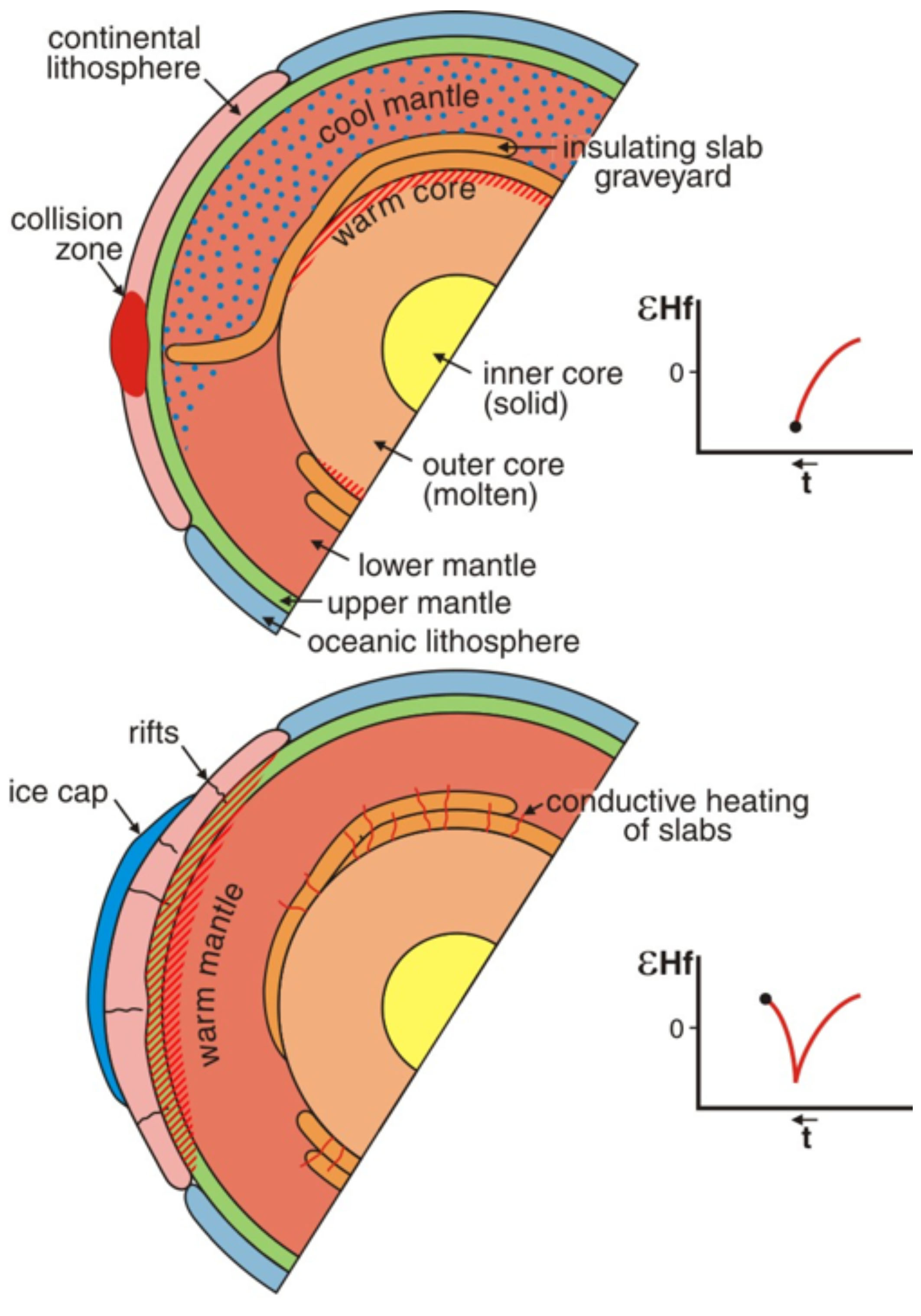
Figure 2. Schematic representation of the two-state Earth in hemispherical cross-sections. Top panel shows a period of supercontinent amalgamation, when widespread subduction causes mantle cooling through a combination of thermal cooling, arising from the introduction of cool oceanic lithosphere, and insulation of the mantle from core heat, through the presence of thick slab graveyards at the core-mantle boundary. Bottom panel shows a period of supercontinent disaggregation, when conductive heating from the core and supercontinent insulation cause mantle warming. Note that widespread glaciations (ice cap on bottom panel) lags behind mantle cooling is a function of the conductive cooling of the crust.
A key feature of the data that links with the geological record is that Earth operated in a "Conditioned Duality", with periods of rapid subduction and supercontinent amalgamation characterised by pulses of hot mantle magmatism and extensive crustal growth and rec-cling, followed by pulses of amalgamated and rifting supercontinents characterised by cool mantle and low rates of crustal growth and recycling (Fig. 2). Periods of warm mantle are characterised by the concentrated global eruption of mantle-derived melts (e.g., komatiites, and emplacement of large igneous provinces, such as the Bushveld magmatic province). But the widespread subduction of old cold oceanic lithosphere, and the associated piling-up of slab graveyards across the core-mantle boundary, led to mantle cooling when supercontinents were amalgamated. It was only after the mantle had warmed up again - through a combination of conduction from below and insulation from above - that the supercontinents were able to split apart and the next supercontinent cycle commence.
These pulses of rapid crust formation lead to the idea of "crustal oversteps", whereby too much crust forms during pulses of supercontinent formation relative to where the planet is in terms of overall heat loss. Thus, crustal recycling and renewed crustal growth is delayed until the volume of crust matches the heat coming out of the mantle. With each stage of supercontinent assembly and related mantle cooling, the tessellation geometry changed in a stepwise manner, reflecting the overall decrease in planetary heat over time. Our current geometry of 12 plates matches a stable dodecahedral tessellation (T3 on Fig. 3), where-as previous steps included less stable geometries with more and smaller plates. However, in the Archean, a stable tessellation of N=32 plates existed as a truncated icosahedron of 12 pentagonal and 20 hexagonal plates of roughly equal size.
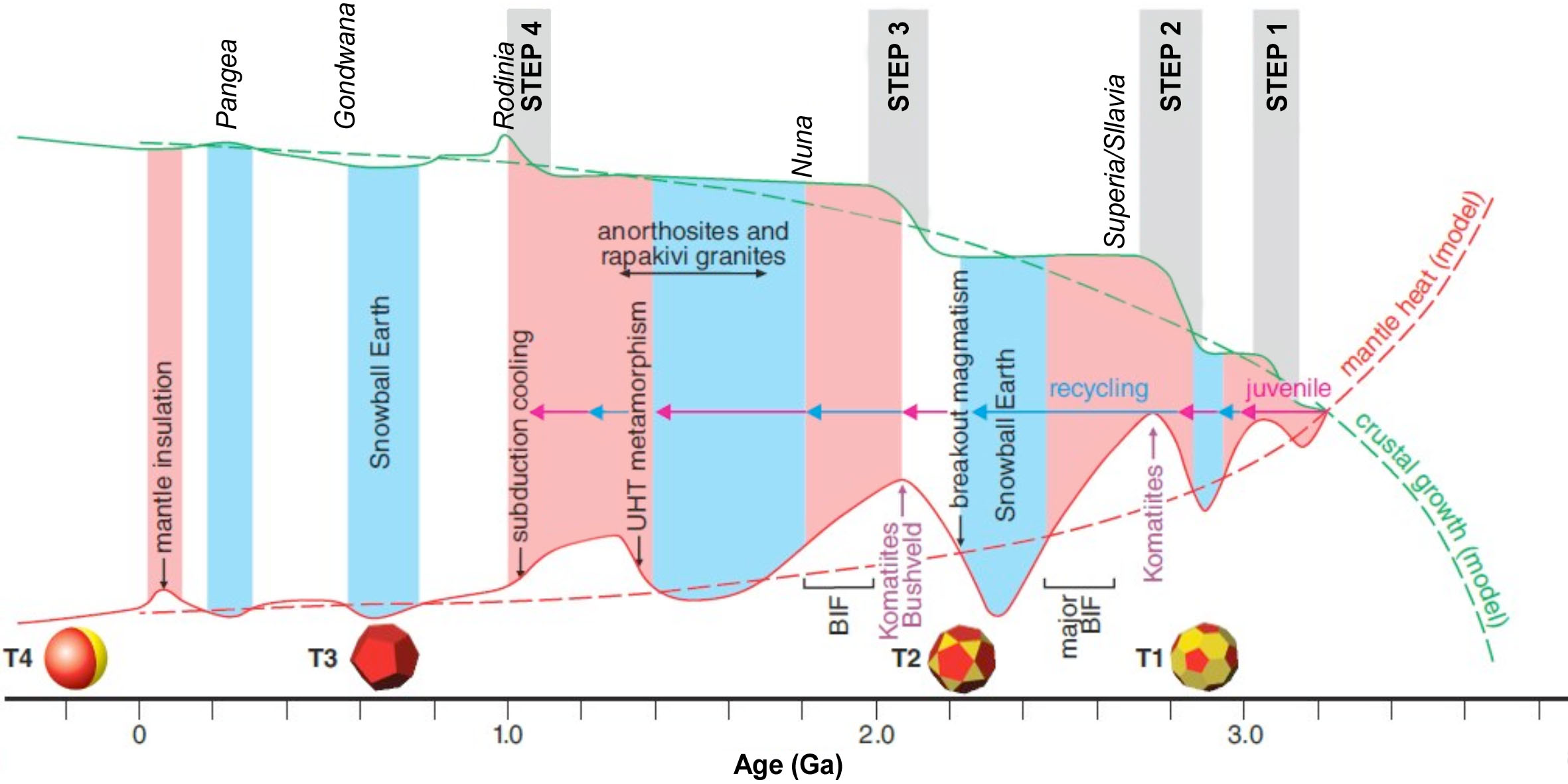
Figure 3. Schematic model of Earth evolution, showing modelled (dashed red curve) and inferred (smooth red curve) heat loss, idealised and inferred crust formation (dashed and smooth green curves, respectively) and tessellation states (T1 to T4). Crustal overstep events (Steps 1-4) are when the volume of continental crust exceeds the ideal volume for a given value of ideal heat loss, and occur immediately following supercontinent amalgamation events (names of supercontinents in italics above crustal growth curves). Heat loss is inferred to vary episodically above the idealised curve, with hot periods (coloured pink) identified by voluminous komatiite and Large Igneous Province (e.g., Bushveld) magmatism, and anorthosite-rapakivi granite magmatism, and cooler periods identified by ice ages (coloured blue). Pink arrows denote pulses of rapid juvenile magmatism; blue arrows periods of predominant crustal recycling. BIF = banded iron-formation; UHT = ultra-high temperature metamorphism.
This project is part of CCFS Theme 2, Earth‘s Evolution, and contributes to understanding Earth‘s Architecture and Fluid Fluxes.
Contacts: Martin Van Kranendonk, Chris Kirkland
Funded by: CCFS Flagship Program 4, UNSW, Curtin University
Mineral exploration on Mars
The geology of Mars is surprisingly well documented. Orbiting satellites have surveyed the Martian surface via hyper-spectral imaging systems, Landers and Rovers have directly observed and analysed the Martian surface, and numerous Martian meteorites are available to the scientific community. The emerging picture is that the basaltic to ultramafic lavas that presently cover a large portion of the Martian surface may have had physical and chemical characteristics akin to the komatiites and ferropicrites that erupted on Earth during the Archean and Proterozoic eons.
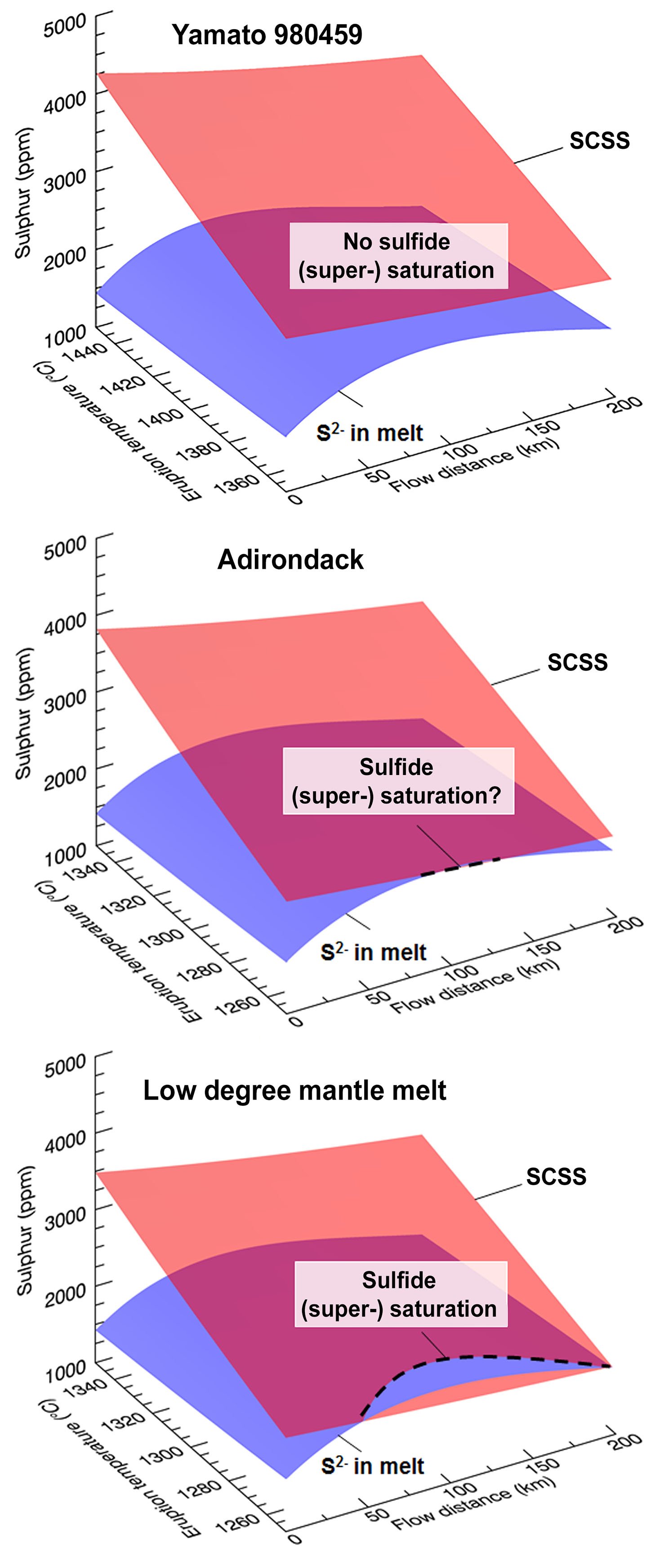
Figure 1. Modelling results for selected unidirectional, gravity-driven steady Martian lava flows in the turbulent flow regime, in the diagram flow distance from the vent (x-axis), eruption temperature (y-axis) and sulfur (i.e. sulfur capacity at sulfide saturation, SCSS, and actual sulfur in the melt). Lava cooling is simulated for convective heat loss to the base and top of the flow, as well as energy consumed due to thermal erosion of substrate and progressive crystallisation of the flow. Several algorithms are integrated to simulate the evolving flow characteristics (e.g., lava temperature, composition, Reynolds number, viscosity, heat transfer coefficient, mechanical and thermo-mechanical erosion rate) at incremental steps downstream. Batch segregation of sulfides may commences when the SCSS (red) and the sulfur in melt (blue) trajectory intersect. The lava types considered are selected Hesperian to Amazonian mantle melts constrained based on a) the study of the olivine-phyric Shergottite meteorite Y 980459, b) the Adirondack-class basalt at the Gusev Crater landing site, and c) low-degree melting experiments on the Martian mantle.
As komatiites and ferropicrites are significant hosts to high-grade Ni-Cu-PGE sulfide mineralisation, the question arises as to whether similar deposits can be found on Mars. Unfortunately, sulfides cannot be easily detected by means of remote sensing (e.g. via hyper-spectral imagery onboard satellites), and no evidence for significant sulfide enrichment has been found through the limited analysis of magmatic rocks at landing sites or through the study of Martian meteorites. Hence, we have investigated the potential loci for Ni-Cu-PGE sulfide mineralisation through the application of predictive mineral system targeting.
On Earth, komatiites and ferropicrites are thought to have been emplaced as turbulent lava flows along conduits and channels with high thermal and mechanical erosion rates. The erosion and assimilation of sulfur-rich substrates probably triggered batch segregation of sulfides and their accumulation in basal units. Similarly, a recent study carried out within the framework of CCFS Flagship Program 4 (CCFS Publication #508) has suggested that the thermal and mechanical erosion of widepsread sulfate-rich sedimentary substrates may have been a common mineralising process in erosive Martian lava flows. However, several mechanisms in this mineralisation model remain unconstrained. In fact, even if the erosive nature of some Martian lava flows is reflected in the occurrence of carved channels, recent numerical studies aimed at exploring their erosive capability did not consider the diverse array of eruption parameters and of potentially sulfate-rich sedimentary substrates, and focused on basaltic bedrock. Most importantly, both the efficiency of Martian lavas to assimilate and reduce sulfate (i.e., S6+) to sulfide (i.e., S2-), rather than the dissolving sulfur as S6+, and the degassing of sulfur-bearing gases during lava emplacement (i.e., S2, H2S, SO2), remain unconstrained.
Our ongoing study aims to refine existing mathematical lava-erosion simulations for turbulent flows, thermodynamic volatile degassing models, and formulations on the stability of sulfides, into a semi-quantitative model for sulfide batch segregation and the formation of komatiite-type sulfide mineralisation in Martian lava flows. We have examined a series of scenarios in which turbulent mafic to ultramafic melts (Fig. 1) with varied chemical and physical characteristics are emplaced over, and potentially erode and assimilate, sulfate-rich substrates, such as the various sedimentary lithologies recently encountered at the Gale Crater and Meridiani Planum landing sites or documented from orbit.
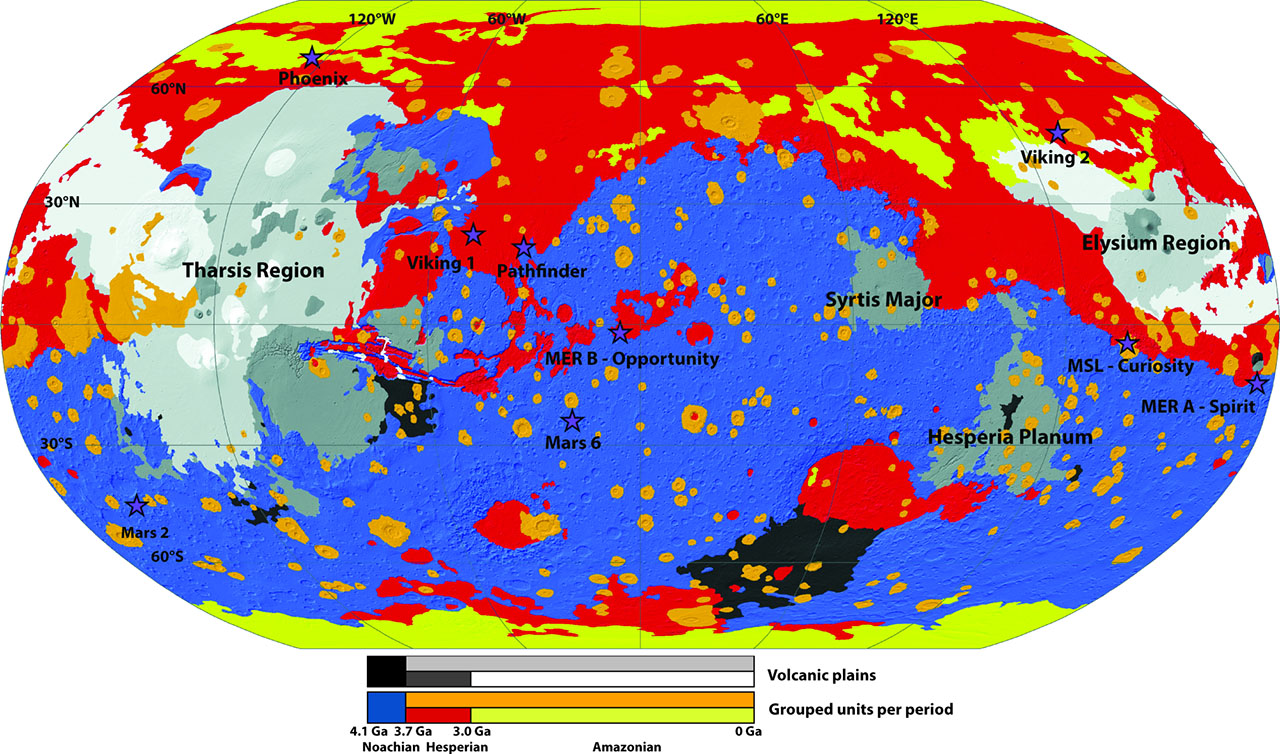
Figure 2. Chronostratigraphic map of Mars showing surfaces of common age. Volcanic terrains are subdivided separately in greyscale levels. Landing sites are highlighted with stars.
Preliminary findings (Fig. 1) support the inference that sulfate assimilation is a potential trigger of sulfide batch segregation and consequent formation of Ni-Cu-(PGE) sulfide mineralisation. The liquidus temperature of the magma appears to be the key parameter in controlling the attainment of sulfide saturation. Therefore, only low-temperature lava flows corresponding to low-degree partial melts of the mantle are promising candidates for the presence of sulfide deposits on Mars (Fig. 2). These types of melts should be more common during the Hesperian (3.7-3.0 Ga) and especially during the Amazonian (<3.0 Ga), rather than during the Noachian, which is dominated by high-degree partial melting conditions. Given these conditions, requiring the interaction of recent volcanism and ancient sulfate-rich deposits, the window of opportunity for ore genesis on Mars may have been much tighter than on Earth, only rarely and sparsely allowing the formation of orthomagmatic mineral systems.
This project is part of CCFS Theme 1, Early Earth, and contributes to understanding Fluid Fluxes.
Contacts: Raphael Baumgartner, Marco Fiorentini, Fabrice Gaillard, David Baratoux
Funded by: CCFS Flagship Program 4
Messengers from the deep: Fossil wadsleyite-chromite microstructures from the Mantle Transition Zone
Seismological studies of Earth‘s mantle reveal three distinct changes in seismic velocity, at depths of 410, 660 and 2700 km; the interval between 410 and 660 km is termed the Mantle Transition Zone (MTZ). Investigations of the MTZ by deformation experiments and geophysical methods suggest that the MTZ has distinct rheological properties. However, their exact cause is still unclear, because actual samples of mantle rocks from deeper than 200 km are rare, and we still know little about the rheological properties and deformation behaviour of olivine polymorphs in the lower parts of the upper mantle.
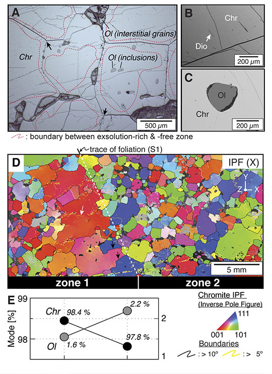
Figure 1. Microstructure of Luobusa chromitite. (A-C) Back-scattered electron (BSE). (A) Equilibrated microstructure of chromite with 120º triple junctions (black arrow) and smooth, nearly straight grain boundaries. Olivine occurs as inclusions and along grain boundaries. Interstitial grains are partially or completely serpentinised. (B) Exsolved diopside needles (Dio) in chromite (Chr). (C) Olivine inclusion (Ol) in chromite (Chr). (D) Colour coded EBSD map showing crystal orientation changes relative to the X direction of the sample reference frame. White and black arrows represent subgrain boundary and migrated grain boundary, respectively. (E) Modal composition of zone 1 and 2 in Fig. 1(D).
Luobusa is one of several large peridotite massifs along the Yarlung-Zangbo suture zone of southern Tibet, which marks the boundary between the Indian and Asian blocks. The podiform chromitites in the Luobusa peridotite have received much attention because they include many ultra-high pressure (UHP) phases, such as microdiamonds (found in mineral separates and in situ), Si-rutile and coesite, as well as a range of highly reduced native elements, carbides and nitrides. Recently, a basic model for the subduction, MTZ UHP metamorphism and exhumation of the Tibetan peridotites has been presented (McGowan et al., 2015, CCFS Publication #522). These observations indicate that the Luobusa chromitites have experienced much higher pressures than the more common ophiolitic chromitites, whose history is restricted to the uppermost part of the mantle (González-Jiménez et al., 2014, CCFS Publication #334).
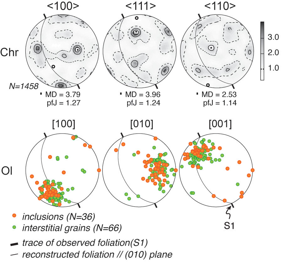
Figure 2. Crystallographic preferred orientation (CPO) of chromites (Chr) and olivines (Ol). Lower hemisphere, equal-area stereographic projections.
MD: maximum density, pfJ: index of fabric intensity.
We have discovered the first direct evidence for crystal-plastic deformation by dislocation creep in the MTZ using a chromitite from the Luobusa peridotite. Chromite grains show exsolution of diopside and SiO2 (Fig. 1A-B), suggesting previous equilibration as an orthorhombic polymorph in the MTZ. Olivine occurs both as inclusions in chromite and interstitially along grain boundaries (Fig. 1C). The grain-size difference between the enclosed and interstitial olivine grains is consistent with evidence for grain boundary migration, because grain boundaries can readily migrate across small grains but can be pinned by larger grains. A decrease in the rate of grain growth due to the presence of grains of a second phase also is consistent with the finer grain size and higher abundance of olivine in interior zone 2 relative to exterior zone 1 (Fig. 1D-E). The abundance of exsolved diopside needles in the cores of chromite grains, vs their absence in the rims, indicates that grain growth occurred after the transition from the orthorhombic high-pressure polymorph chromite to cubic chromite.
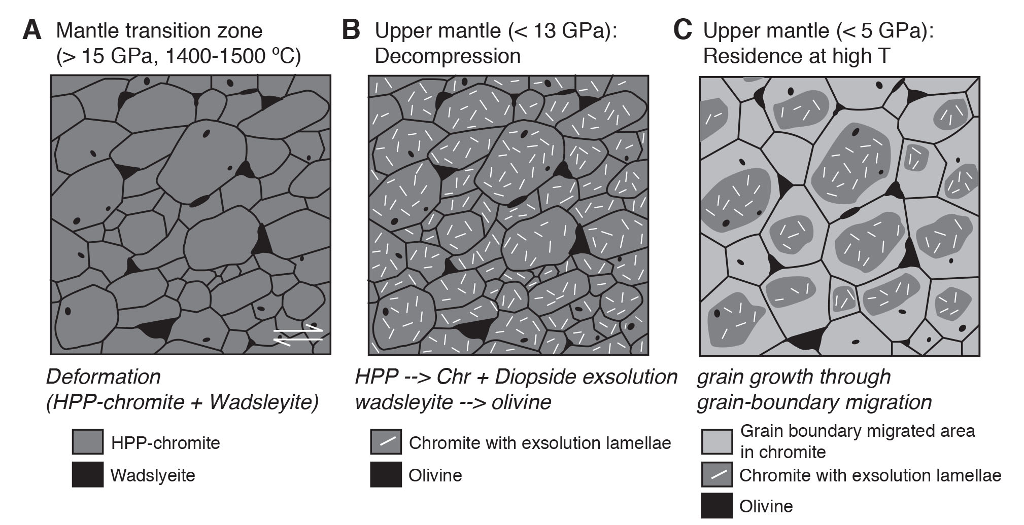
Figure 3. Schematic model of microstructural evolution in Luobusa chromitite. (A) Deformation of HPP (High Pressure Polymorph)-structured chromite and wadsleyite in Mantle Transition Zone. (B) Transformation from HPP structure to chromite; diopside/coesite exsolution; transformation of wadsleyite to olivine. (C) Grain growth through static grain-boundary migration to produce coarse equilibrated microstructure, with exsolution-rich cores and exsolution-free rims. Larger interstitial olivine grains pin the migrating boundaries.
Electron backscattered diffraction (EBSD) analysis reveals that olivine grains co-existing with exsolved phases inside chromite grains and occurring on chromite grain boundaries have a single pronounced crystallographic preferred orientation (CPO) (Fig. 2). This suggests that olivine preserves the CPO of a high-pressure polymorph (wadsleyite), which implies the activation of the (011)[100] slip system in wadsleyite, before the high-pressure polymorph of chromite began to invert and exsolve. Chromite, a cubic phase also shows a significant CPO, suggesting that this was acquired while the chromite existed in the UHP orthorhombic polymorph. Thus, the fine-grained high-pressure phases were deformed by dislocation creep in the MTZ (Fig. 3). Significant grain-boundary migration under static conditions during passive exhumation produced an equilibrated microstructure. Grain growth masked at first sight its MTZ deformation history, but preserved the core-rim structure with exsolved diopside only in the cores, as well as the high-PT fabric. The relict olivine-chromite fabric of this Luobusa chromitite provides the first direct evidence of significant crystal-plastic deformation in the MTZ. These unique observations provide a window into the deep Earth, and constraints for interpreting geophysical signals and their geodynamic implications in a geologically robust context (Satsukawa et al. 2015; CCFS Publication #673).
This project is part of CCFS themes 2 and 3, Earth‘s Evolution and Earth Today, and contributes to understanding Earth‘s Architecture and Fluid Fluxes.
Contacts: Takako Satsukawa, Bill Griffin, Sandra Piazolo, Sue O‘Reilly
Funded by: CCFS Flagship Program 1, ECSTAR
How kimberlites get to the surface (or not)
Kimberlites are economically and scientifically valuable because they are the major hosts to diamonds, entrain abundant mantle and crustal xenoliths and represent the deepest mantle-derived magmas (>150-200 km) that we can see at Earth‘s surface. Despite their importance, and at least 40-50 years of dedicated studies, several issues remain unresolved about kimberlite petrology, geochemistry, mineralogy and volcanology. These include: 1) the composition of kimberlite melts in the deep Earth and when they reach the upper crust; 2) the depth where kimberlite melts are generated; 3) the causes of the very fast ascent (several m/s) of kimberlite magmas; 4) the extent to which kimberlite rocks are modified by syn- and post-emplacement processes, such as ground-water alteration.
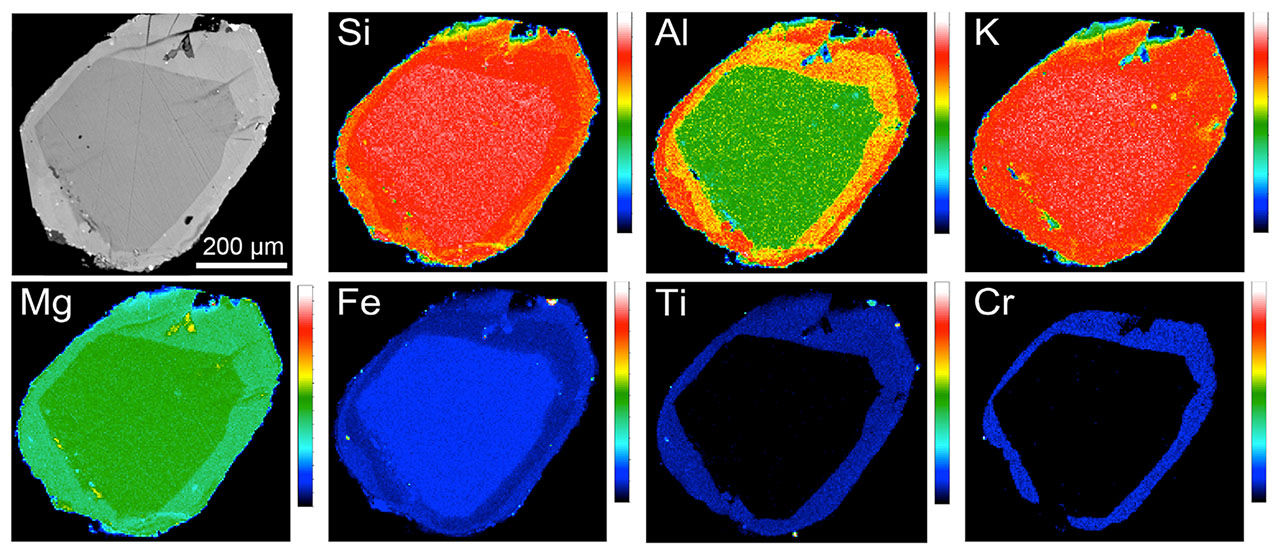
Figure 1. Scanning electron microscope (SEM), back-scattered electron (BSE) image and X-ray elemental maps of a typical concentrically-zoned phlogopite macrocryst from the Bultfontein kimberlite. The coloured scales on the right of each panel indicate the relative concentration of each element, i.e. “cool” colours (blue, black) = low concentrations; “warm” colours (red, orange) = high concentrations.
New research by ARC DECRA fellow Andrea Giuliani and his research group provides new insights into two of the above issues, namely the ascent mechanism(s) of kimberlite magmas and the evolution of kimberlite melts during their ascent through the lithospheric mantle.
The driving forces that promote the rapid ascent of kimberlite magmas are poorly constrained. For example, it has been proposed that exsolution of a CO2-rich vapour phase at mantle depths provides the main propellant. However, this is hard to reconcile with the carbonate-rich nature of kimberlite matrices and, hence the parental magma(s); the CO2 obviously has not escaped. In addition, many kimberlite magmas (e.g., magmatic dykes several km in length) have not been emplaced explosively. Finally, if magma ascent is not driven by volatile exsolution, we might expect the highly reactive kimberlite melts to be entirely consumed through reaction with mantle wall rocks. The ascent of kimberlite magmas to Earth‘s surface, therefore, requires unique conditions.
To investigate the evolution of kimberlite magmas, we need phases that preserve geochemical signatures of magma interactions during transport through the mantle and the crust. Phlogopite mica is a common mineral in kimberlites, where it spans a range in size from macrocrysts (~> 0.5 mm; Fig. 1) to a groundmass phase (~< 0.1 mm). It also preserves large compositional variations, a repository of information on the evolution of kimberlite and related melts.
In CCFS publication 680, Dr Giuliani and colleagues from the University of Melbourne and Tasmania, report new compositional data for phlogopite in the Bultfontein kimberlite (Kimberley, South Africa; the kimberlite type locality) and in mantle xenoliths entrained by the Kimberley kimberlites. Concentric zoning patterns in phlogopite macrocrysts in the Bultfontein kimberlite (Fig. 1) record a complex history of episodic crystal growth. Internal zones of macrocrysts and some cores in groundmass grains have Ti-Cr-rich compositions similar to overgrowth rims on phlogopite in mantle xenoliths from the Kimberley and other southern African kimberlites and matrix grains in polymict breccia xenoliths from Bultfontein. In mantle xenoliths, the phlogopite overgrowths have been previously interpreted as crystallising from kimberlitic fluids/melts, while polymict breccias are widely regarded as failed kimberlite intrusions at mantle depths. These results suggest that the Ti-Cr-rich zones of phlogopite in the Bultfontein kimberlite were produced in the mantle by reaction with one or more batches of kimberlite melt before phlogopite entrainment into the magma and transport towards the Earth‘s surface. Similar Ti-Cr-rich phlogopite cores were also identified in the groundmass of kimberlites from North America. Inner rims in phlogopite macrocrysts from the Aries kimberlites/orangeites and olivine macrocrysts and groundmass grains from kimberlites in Greenland, Canada, southern Africa and Russia have also been attributed to kimberlite metasomatism in the mantle.
Figure 2. Conceptual model showing different stages in the evolution of a kimberlite magmatic system traversing the lithospheric mantle. Stage A: ‘failed‘ kimberlite intrusion stalled at lithospheric mantle depths with the formation of polymict breccias and metasomatism of the conduit wall rocks. Stage B: the ascending kimberlite magma intrudes the pre-existing conduit and entrains wall rocks, including polymict breccias and previously metasomatised components (i.e. macrocrysts). The patchy occurrence of ‘kimberlite-metasomatised wall rocks‘ illustrates that not all material entrained and transported to the surface is metasomatised, in agreement with the occurrence of abundant peridotite and eclogite xenoliths, that show minimal evidence of metasomatism by kimberlite magmas or related fluids. Other possible reasons for the abundance of non-metasomatised wall rocks include sampling of rocks several metres away from the metasomatised conduit, which could be incorporated into the conduit during the turbulent ascent of the larger kimberlite magma pulses and preferential melting and disaggregation of metasomatised wall rocks during kimberlite magmatic activity. The scale is based on a typical thickness of kimberlite dykes of about 0.5-1 m.
This evidence, coupled with the occurrence of polymict-breccia xenoliths in South African and Russian kimberlites, indicates that ‘failed‘ kimberlite intrusions are probably a common phenomenon. Given the highly reactive nature of kimberlite melts towards mantle wall rocks, kimberlite magmas may only be able to reach the surface by ascent through a pathway created by multiple earlier magma pulses that metasomatise the conduit, insulating the later magmas from reaction with the surrounding mantle rocks (Fig. 2). This model might represent the fundamental ascent mechanism for kimberlite magmas.
This study has also revealed that, in addition to the widely recognised magmatic and xenolithic components, kimberlite rocks host mantle-derived ‘antecrysts‘ (e.g., the high Ti-Cr zones of phlogopite grains), which are the products of ‘failed‘ kimberlite intrusions and were entrained by later kimberlite magmas. Mantle-derived antecrysts are an integral part of the kimberlite groundmass, where they occur as cores in groundmass grains. These antecrysts contribute to the bulk composition of kimberlites, and further complicate efforts to determine the composition of parental kimberlite melts by bulk-rock analysis.
This project is part of CCFS Theme 2, Earth‘s Evolution, and contributes to understanding Earth‘s Architecture and Fluid Fluxes.
Contact: Andrea Giuliani
Funded by: ARC Discovery Early Career Researcher Award (DECRA)
A new zircon guide to copper-fertile igneous intrusions
The hunt for undiscovered mineral resources in igneous bedrock is increasingly reliant on “halos” - signals around an ore deposit that are much larger than the ore deposit itself. Stream sediments shed during erosion of an ore-bearing igneous complex can provide such a halo and can serve as guides to undiscovered ore upstream from the sediment sampling site.
CCFS research has identified several geochemical discriminants of granitic igneous rocks that produced magmatic-hydrothermal copper deposits. This type of deposit accounts for more than 75% of global copper production (R. Loucks, Australian Journal of Earth Science, 2014). Among the geochemical discriminants is the ratio europium/ytterbium, represented by the parameter (Eu/Eu*)/Yb. Eu/Eu* represents the “Europium anomaly” - the deviation of the measured abundance (Eu) from the abundance expected from the measured amounts of samarium and gadolinium (Eu*), which have atomic numbers just below and above, respectively, that of europium. Granitoid melts related to copper ores are distinguished from barren granitoid melts by unusually high values of Eu/Eu* and unusually low values of Y; the ratio (Eu/Eu*)/Yb magnifies the distinction of copper-ore-forming granitoid magmas from barren granitoid magmas.
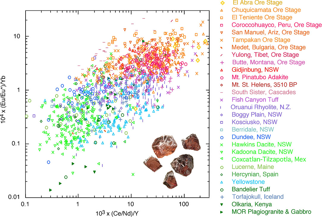
Figure 1. Trace elements in more than 3000 zircon crystals from copper-ore-bearing igneous complexes (red and orange symbols) and from unmineralised igneous complexes (violet, blue, green symbols). Because zircon robustly survives chemical alteration of its host rock and long-distance sedimentary transport, zircons in sediments can guide mineral exploration teams to copper-mineralised igneous complexes upstream from the sediment-sampling site.
Zircon, a ubiquitous trace mineral in granitic igneous rocks, takes in small amounts of Eu and Yb that substitute for some of the zirconium atoms in the zircon structure. We have discovered that zircon inherits a version of the (Eu/Eu*)/Yb ratio in its parent granitoid melt, warped by zircon‘s systematic preference for Yb relative to Eu. Europium atoms in the silicate melt can have an electric charge of +2 or +3; the granitoid melt‘s ratio of Eu2+/Eu3+ is captured in the quantity Eu/Eu*. Zircon inherits a version of the parent granitoid melt‘s Eu/Eu*, warped by zircon‘s strong preference for Eu3+ relative to Eu2+. Zircon also takes in small amounts of the elements cerium (Ce) and neodymium (Nd); magmas related to copper ores have unusually low abundances of Y, and zircon that crystallises from Y-depleted magmas inherits that feature as well. Finally, zircons from copper-ore-forming granitoid magmas have distinctively high values of the ratio Ce/Nd, as compared to zircons from barren granitoids. The ratio (Ce/Nd)/Y in zircon thus magnifies the distinction between zircons from mineralised and unmineralised granitoid rocks.
We have measured (Eu/Eu*)/Yb and (Ce/Nd)/Y in hundreds of zircons from four major magmatic-hydrothermal ore deposits and nine barren igneous complexes, and compiled from the literature more than 2500 analyses of zircons from other copper-ore-bearing and barren igneous complexes. Figure 1 illustrates the efficacy of these parameters in discriminating zircons in copper-ore-bearing igneous complexes from zircons in barren reference suites. Because zircon is chemically and mechanically robust, it survives chemical alteration of its host rock and long-distance transport in streams. Our discovery allows the trace-element chemistry of zircon to be used by mineral exploration companies as a pathfinder to copper-fertile igneous complexes that may contain undiscovered ore. The analytical method used in our study, laser-ablation inductively-coupled plasma mass spectrometry, can do hundreds of analyses per day at a price that is cost-effective for mineral exploration.
This project is part of CCFS Themes 2 and 3, Earth‘s Evolution and Earth Today and contributes to understanding Fluid Fluxes.
Contacts: Robert Loucks, Yongjun Lu, Marco Fiorentini
Funded by: CCFS Flagship Program 2
Do continental flood basalts need plumes?
It has previously been postulated that the Earth‘s hydrous mantle transition zone may play a key role in intra-plate magmatism, but no confirmatory evidence has been reported. Here, we argue that high-temperature hydrothermally-altered subducted oceanic crust was involved in generating the Late Cenozoic Chifeng continental flood basalts of East Asia. This study combines oxygen isotopes with conventional geochemistry to provide the first evidence for an origin in the hydrous mantle transition zone.
Figure 1. (a) Schematic map of the Late Cenozoic intraplate volcanic province in Central East Asia. (b) Covariations of olivine δ18O, major-trace elements, and 39Ar/40Ar ages as a function of eruptive longitude (for detail see text in X.C. Wang et al., 2015, Nature Communications, 6). Data points represent average of analysed whole-rock or olivine samples from individual Chifeng CFBs; error bars represent one standard deviation for each group of lava or olivine. r: correlation coefficient.
The most striking observation in this study is that oxygen isotopes, 39Ar/40Ar ages, and other geochemical features of the Chifeng CFBs (SiO2, Nb, Sm/Nd, and Ce/Pb) are correlated with their distance from the western edge of the stagnant Pacific slab (Fig. 1). In a westward direction, the lavas decrease in age, become progressively depleted in silica and have lower Sm/Nd ratios, whereas they show progressive enrichment in Nb and have higher Ce/Pb ratios. Importantly, the δ18O values of olivine in the basalts increase westward away from the stagnant slab (Fig. 1). Thus the lavas immediately above the western edge of the stagnant Pacific slab are over-saturated in silica, and have the oldest eruptive ages, the lowest olivine δ18O and possibly the highest fluid contents. The low-δ18O lavas are characterised by enrichment of silica, high positive Sr anomalies, high Al2O3, and depletion in incompatible trace elements (Fig. 2), and Ce/Pb ratios like those commonly associated with subducted slabs (Fig. 3). Furthermore, the lower δ18O is coupled with depletion in high field-strength elements (e.g., Nb; Fig. 2) and other incompatible elements, as evidenced by decreasing La/Sm ratios.
Figure 2. Correlation between average oxygen δ18O values and (a) SiO2, (b) Sm/Nd, (c) Sr*/Sr, (d) La/Sm, (e) Fo contents, and (g) Al2O3, and (h) Lu/Hf and (f) Nb-Ce/Pb.
This is confirmed by the studies of olivine-hosted melt inclusions from the south-eastern extremity of the Chifeng CFBs, erupted directly above the western edge of the stagnant Pacific slab. The melt-inclusion data imply that these CFBs were mainly derived from an olivine-free pyroxenite-dominated source with high water content (>450 ppm). These observations show that the low-δ18O end-member melts most likely originated from hydrothermally-altered oceanic gabbros. Thus, the correlation of recycled oceanic gabbro-derived signatures with the inferred position of the stagnant Pacific slab within the hydrous MTZ provides an indirect, but important, constraint on the depth of the mantle source.
Figure 3. Effect of slab stagnation and water cycling (wet upwelling, upward percolation, and re-fertilisation) on the upper mantle thermochemical state. This model is mainly based on the strong spatial correlation of geochemical features with distance of eruptive lavas relative to the edge of the stagnant slab. It involves water partitioning in the Earth‘s mantle, behaviour of slab-triggered wet upwelling and upward percolation, hydrous mantle melting, the mantle wedge model, and upwelling from the hydrated mantle transition zone.
These observations lead us to propose an alternative model, whereby slab-triggered wet upwelling produces large volumes of melt that may rise from the hydrous mantle transition zone. This model explains the lack of pre-magmatic lithospheric extension or a hot-spot track and also the arc-like signatures observed in some large-scale intra-continental magmas. Deep-Earth water cycling, linked to cold subduction, slab stagnation, wet mantle upwelling, and assembly/breakup of supercontinents, can account for the chemical diversity of many continental flood basalts (Fig. 3).
This project is part of CCFS Theme 2, Earth‘s Evolution, and contributes to understanding Earth‘s Architecture and Fluid Fluxes.
Contacts: Xuan-Ce Wang, Simon Wilde
Funded by: Wang ARC Future Fellowship, National Natural Science Foundation of China (Grant No. 41222023 and 40803010) and the State Key Laboratory of Isotope Geochemistry at the Guangzhou Institute of Geochemistry, Chinese Academy of Sciences (Grant No. SKLIG-KF-13-07)
Ancient mantle lithosphere beneath the Khanka massif in Russian Far East: In situ Re-Os evidence
The Altaids (or Central Asian Orogenic Belt; CAOB) has been proposed as the world‘s largest site of juvenile crust formation during the Phanerozoic eon. Nevertheless, Kröner et al. (2014) documented that crustal evolution in the CAOB involved both addition of juvenile material from the mantle as well as abundant reworking of varying proportions of older crust throughout its accretionary history. Within the CAOB, several microcontinental blocks have been recognised, although it is still unclear if all of these truly predated accretion of the CAOB.
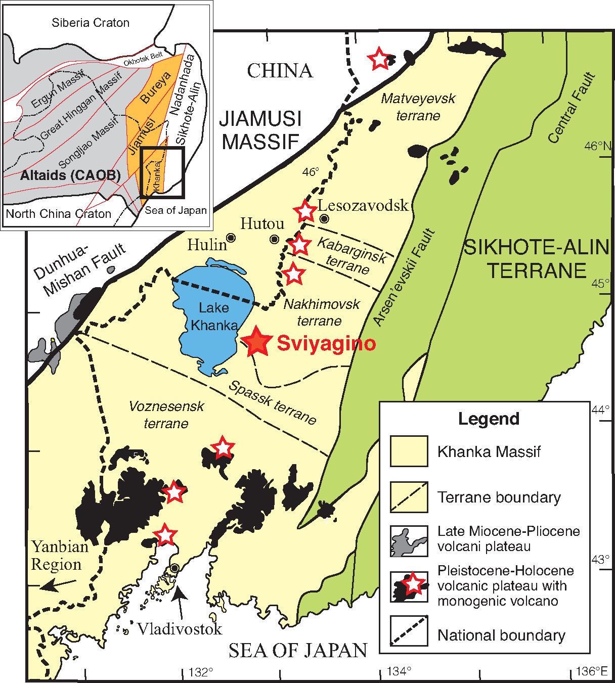
Figure 1. Tectonomagmatic map of the Khanka massif in relation to adjacent areas of NE China and Russia. Red stars: localities of individual volcanic domes; solid red star: locality of xenoliths from the Sviyaginsky volcano.
This is also the case for the extreme eastern margin of the CAOB, which is composed of three microcontinental blocks: the Bureya, Jiamusi and Khanka massifs, located between the Siberia and North China cratons; the ongoing Pacific-plate subduction since the Mesozoic complicates the situation (Fig. 1). Lack of constraints has led to widely divergent views as to the origin and initial location of these blocks. It has been postulated that the Jiamusi-Khanka massif may be derived from a peri-Gondwana position, or be an exotic block of affinity to South China Block, or a fragment of the Siberian Craton.
Recent studies have demonstrated that Os model-age spectra from mantle xenoliths commonly show age peaks corresponding to the ages of thermal/tectonic events in the overlying crust. Thus, in situ analysis of Re-Os isotopic compositions by laser sampling of single sulfide grains makes it possible to test the existence of a Precambrian microcontinent within the eastern CAOB complex and clarify whether the Khanka massif has a tectonic affinity to the Siberian Craton. The Os isotope compositions of sulfides in mantle xenoliths hosted by late Miocene alkali basalts from the Sviyaginsky volcano, Russian Far East (Fig. 1), reveal the presence of Archean-Proterozoic subcontinental lithospheric mantle (SCLM) beneath the Khanka massif. Both their TMA and TRD model ages reveal similar peaks at 1.1 and 0.8 Ga suggesting later thermotectonic events in the SCLM, whereas TRD model ages extend back to 2.8 ± 0.5 (2σ) Ga. The events recognised in the SCLM are consistent with those recorded in crust of the Khanka massif. The sulfide Os-isotope data show that the SCLM beneath the Khanka massif had formed at least by the Mesoproterozoic, and probably in the Archean, and was subsequently metasomatised during juvenile crustal-growth events related to the evolution of the Altaids. The peak Os model age pattern of the Sviyaginsky sulfides, compared to sulfide Os model ages from these terrains, provide further insights on the origin of the Khanka massif. In Figure 2, peak Os model age patterns of sulfides in mantle xenoliths from Turkana Depression in south Ethiopia on the Arabian-Nubian Shield (Wang et al., 2005), the Penghu Islands at the margin of South China Block (Wang et al., 2003; 2009), and the Khamar Daban Ridge in south Russian Siberia (Slyudyansky terrane; our unpublished data) are shown for comparison with the Sviyaginsky sulfides. Sulfides from south Ethiopia (Fig. 2b) do not have the Mesoproterozoic-Archean Os age record, and their peak Os age patterns are not consistent with the Sviyaginsky sulfides. The Sviyaginsky sulfides have pronounced peak ages at 1.1-1.2 and 0.8 Ga, while the Taiwan sulfides obviously do not have an age peak at 1.1-1.2 Ga (Fig. 2c). Only sulfides from the Slyudyansky terrane have peak age patterns similar to the Sviyaginsky sulfides (Fig. 2d). Thus the Khanka massif has tectonic affinities to the Siberian Craton and probably was derived from it, as proposed by Zhou et al. (2010).
Figure 2. Cumulative probability diagrams (Ludwig, 2000) of TRD model ages of sulfides from (a) the Sviyaginsky volcano; (b) the Turkana Depression in south Ethiopia on the Arabian-Nubian Shield (Wang et al., 2005); (c) the Penghu Islands in Taiwan at the margin of the South China Block (Wang et al., 2003, 2009a); and (d) the Khamar Daban Ridge in south Russian Siberia on the Slyudyansky terrane (our unpublished data). Thick line represents the distribution pattern of ages. The histogram of ages represented by thin grey lines is also shown. Grey bars indicate sulfides with low187Re/188Os ratios (<0.07) having pristine characteristics without later modification. Corresponding crustal events are shown for comparison.
This project is part of CCFS themes 1 and 2, Early Earth and Earth‘s Evolution, and contributes to understanding Earth‘s Architecture and Fluid Fluxes.
Contacts: Kuo-Lung Wang, Sue O‘Reilly, Bill Griffin
Funded by: Ministry of Science and Technology, Taiwan projects NSC 101-2923-M-001-001-MY3, NSC99-2116-M-001-017
Palaeoproterozoic Superia Supercraton: New insights from Yilgarn
The hypothesis of supercontinent cycles predicts the assembly of a supercontinent in Siderian time (2.5-2.3 Ga). Bleeker and Ernst (Dike swarms 2006) postulated the existence of the Superia supercraton at that time, which included the Superior, Karelia and Hearne cratons. Söderlund et al. (Precambrian Research 2010) provided some evidence that the Zimbabwe and Yilgarn cratons could also have formed part of Superia. To test this hypothesis we studied the Erayinia mafic dykes in the eastern part of the Yilgarn Craton. This study has been done in collaboration with Bert De Waele (SRK Consulting), Sarah Jones (St Barbara Limited), Ulf Söderlund (Lund University) and Richard Ernst (Carleton University) (CCFS publication #508).
Figure 1. 2.4 Ga reconstruction of the Superia supercraton, stars denote suggested position of the mantle plumes.
Previously undated Erayinia dykes have been thought to belong either in the 2.42-2.41 Ga Widgiemooltha LIP or in the 1.21 Ga Marnda Moorn LIP. We dated Erayinia dykes at 2401 ± 1 Ma (U-Pb TIMS baddeleyite). The palaeomagnetic analysis isolated a stable primary remanence with steep downward direction similar, but not identical to that of the previously studied Widgiemooltha dykes. This slight directional difference and the opposite palaeomagnetic polarity suggest that Eryiania dykes are probably not related to the 10 m.y. older Widgiemooltha LIP. The comparison of Eryiania and Widgiemooltha palaeopoles suggest the angular velocity of the Yilgarn Craton between 2410-2420 and 2400 Ma at ~1˚/m.y., which is comparable with similar estimations for the angular plate velocities in the Phanerozoic. The estimated amplitude of the geomagnetic secular variations at c. 2400 Ma is slightly higher than predicted by the existing models for the last 5 m.y. at the c. 64˚latitude.
New palaeomagnetic poles, together with previously published palaeopoles and with the analysis of Palaeoproterozoic LIPs distribution, led us to a modified reconstruction of the Superia supercraton at c. 2.4 Ga (Fig. 1) and confirmed the suggestion that the Superior, Yilgarn, Zimbabwe, Kola-Karelia, North Atlantic, Hearne and Wyoming cratons could be parts of this supercraton.
This project is part of CCFS themes 1 and 2, Early Earth and Earth‘s Evolution, and contributes to understanding Earth‘s Architecture.
Contact: Sergei Pisarevsky
Funded by: CCFS Flagship Program 5, LIPs - Supercontinent Reconstruction - Resource Exploration Project (www.supercontinent.org)
3D Magma emplacement
Magma generation and emplacement is an important process of material transfer that shapes much of Earth‘s continental crust. Molten material generated below the lithosphere contributes to the growth of the continental crust, erupting as magmas in near-surface regions or large growing magma bodies at sub-crustal levels. Understanding the physical processes involved in the generation and emplacement of magma requires knowledge about the geochemical and physical properties of melt, magma (melt plus crystals) and host lithologies. Different magma sources, melting conditions and differentiation processes have been proposed to account for the basaltic and andesitic magmatism that operates on Earth‘s surface. However, it is becoming increasingly apparent that the evolution of magmas is intrinsically related to transport mechanisms, which control emplacement depths, structures and petrogenesis. Transport mechanisms that have been proposed in the past can be divided into two main groups, processes of diapiric-like emplacement and those that favour magma ascent in dikes. However, it seems that nature combines both processes, which may simultaneously or sequentially control ascent and emplacement. On the other hand, crustal heterogeneities, rheological anisotropy and local and far-field stresses are likely to play key roles in magma emplacement. Feedback between these processes will affect how and where magma is stored.
Figure 1. 3D image represents an intrusion and the fracture system that develops around it. a) simulating a ring complex. b) simulating the directionality of the intrusion with a pre-existing weak structure, such as a fault. Top right (a, b): relative elevation: blue < 0, red - > 0, green = 0. Bottom right (a, b): cross-section through the middle of the intrusion showing rock composition.
Despite the rapidly growing volume of geological, geophysical and experimental data on magma rheology, chemistry, structure and emplacement, numerical simulations on the dynamics of magma ascent and emplacement are comparatively rare. Numerical studies devoted to magmatism have instead mainly focused on the internal dynamics of magma chambers, and little is known about the visco-brittle/plastic interplay between magma and crust.
The new set of 3D numerical experiments demonstrates the first-order importance of host rock rheology upon emplacement; it is responsible for the variable shapes of the intrusions, such as cone shaped, saucer shaped, funnel shaped and tabular. Brittle parameters such as cohesion and friction angle, and especially the strain limit for fracture-related weakening are important. For example, with a fully mafic crust and strain hardening, the shape of the intrusion and the surrounding faults imitate the shapes of magmatic bodies observed in nature, such as “ring complexes” (Fig. 1a), which are incredible magmatic structures, and a rich source of information on magma transport and emplacement. On the other hand, with strain weakening the intrusion travels very rapidly through the crust and is of relatively small diameter without much deformation of the host rock.
This study also allows a glimpse into a long-standing debate on how and if magmas are controlled by extensional regimes or pre-existing shear zones (Fig. 1b).
It has been confirmed that pre-existing faults or shear zones control the development of the shape of the intrusion. Interestingly this control is better observed with mafic host rocks than with felsic rocks. In the first instance the shape of the intrusion strictly follows the pre-existing zones of weakness and flat dykes can be observed (Fig. 1b). On the other hand, the boundaries of intrusions into felsic host-rocks do not sharply follow the pre-existing weak zones.
This project is part of CCFS Theme 2, Earth‘s Evolution, and contributes to understanding Earth‘s Architecture and Fluid Fluxes.
Contact: Weronika Gorczyk
Funded by: ARC Linkage, CCFS Flagship Program 2
Solving the “Ophiolite Conundrum”
Ophiolites record shallow plate-tectonic processes in oceanic basins, arcs and ocean-continent transitions on Earth; recent confirmation of natural ultrahigh-pressure and super-reduced phases (e.g., diamond, moissanite) from Tibetan ophiolites shows that these pieces of ancient lithospheric fragments can also provide new insights into the deep convective mantle and even the Transition Zone (410-660 km). However, a long-term global conundrum (supra-subduction-zone-type ophiolites with mid-ocean-ridge features) impedes further understanding of ophiolite formation and relevant geodynamic processes. We have carried out a systematic petrological and geochemical investigation of the Zedang ophiolite (outcrop area ~100 km2) in the Yarlung Zangbo Suture Zone (South Tibet, China), which marks a tectonic boundary between the Indian and Asian continents.
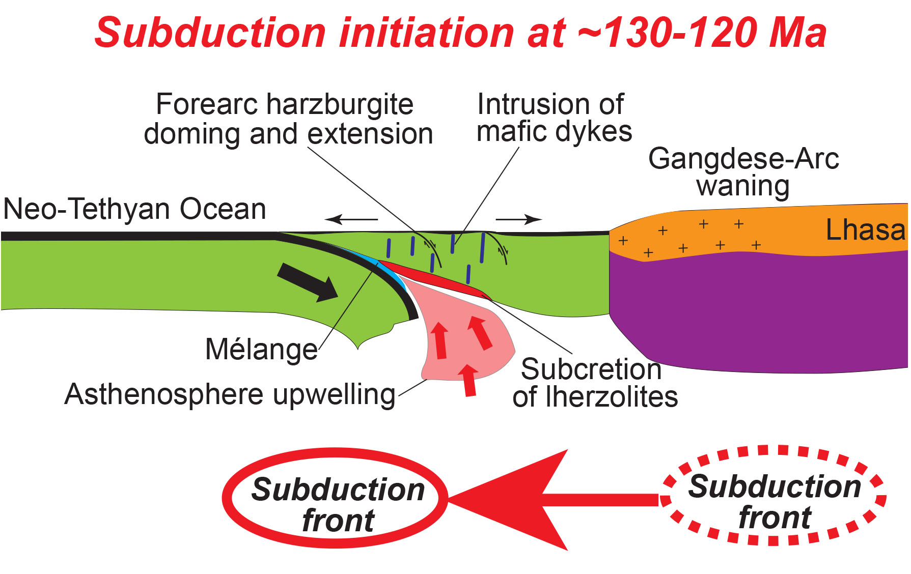
Figure 1. Cartoon illustrating the southward jump of the Neo-Tethyan subduction front at ~130-120 Ma, resulting in the subduction initiation and forearc lithosphere accretion as future Yarlung Zangbo ophiolites in South Tibet, China.
In the Zedang ophiolite, detailed mineral chemical data reveal a two-layered lithospheric mantle structure: the harzburgite domain in the east [spinel Cr# (mole Cr3+/(Cr3++Al3+) = 0.62-0.33] is more depleted than the lherzolite domain in the west (spinel Cr# = 0.30-0.17) and shows much lower equilibration temperatures (differences of ~250-150 K) than the lherzolites. Clinopyroxene trace-element compositions indicate that the harzburgites underwent pervasive metasomatism after melt extraction, while the lherzolites did not.
New zircon U-Pb ages show that the harzburgites were intruded by dolerite dykes with clear chilled margins at ~130-128 Ma, consistent with the widespread but minor mafic magmatism at ~130-120 Ma in the Yarlung Zangbo ophiolites. Nd-Hf isotopic data indicate that the Zedang lherzolites subcreted the pre-emplaced harzburgites concurrently with the intrusion of the dolerite dykes into the harzburgites, and that the lherzolites and dolerites both were derived from upwelling asthenosphere with minor slab input. Furthermore, available zircon geochronology and Hf-isotope data show that juvenile magmatism in the northern Gangdese Arc (southern part of the Lhasa microcontinent) almost ceased from ~130-120 Ma. These observations suggest a southward jump of the Neo-Tethyan subduction front from beneath the Gangdese subarc region (north) to the forearc oceanic lithosphere (south) during this short period. This jump may have been triggered by plate reorganisation related to the collision between the Lhasa and Qiangtang blocks, and the Gondwanaland breakup in the early Cretaceous.
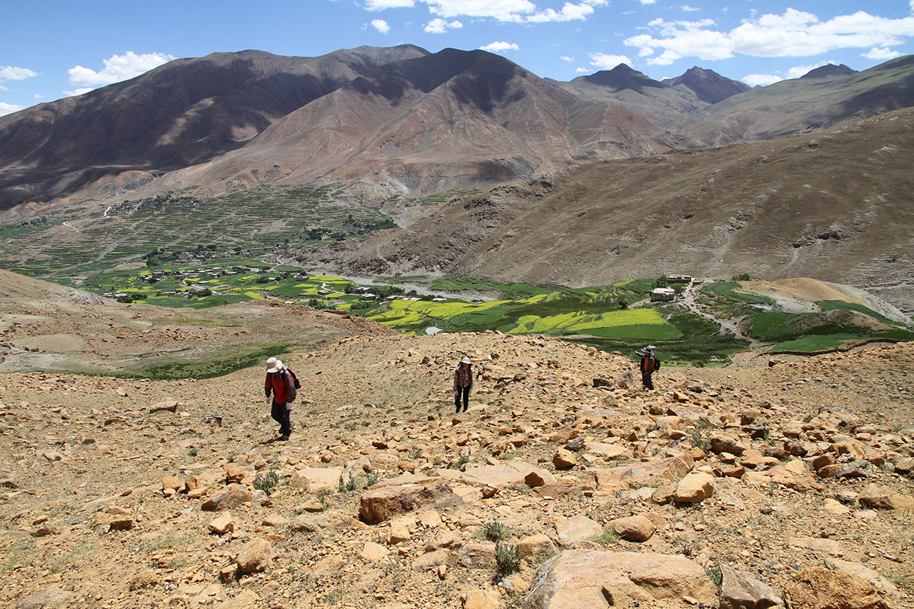
Figure 2. Kang Wu, Xiaoxiao Huang, Qing Xiong and Xiaohan Gong climbing the Dazhuka Mountain, Xigaze ophiolite (S. Tibet).
We find that the relocation of the Tethyan subduction front caused the subduction initiation in front of the southern margin of the Gangdese Arc at ~130-120 Ma, and consequently resulted in asthenosphere upwelling, subcretion of lherzolites, doming and extension of the overlying harzburgitic forearc lithosphere and the intrusion of mafic dykes (Fig. 1). The extensional structure and MORB-type magmatism are similar to those usually observed in slow-spreading mid-ocean-ridges, and can be easily interpreted as formed during subduction initiation beneath pre-existing buoyant lithosphere, consistent with the geochemical evidence for a subduction-related evolution. Our multi-stage forearc accretion model provides a new solution to reconcile the global “Ophiolite Conundrum”.
This project is part of CCFS Theme 2, Earth‘s Evolution, and contributes to understanding Earth‘s Architecture and Fluid Fluxes.
Contacts: Qing Xiong, Bill Griffin, Sue O‘Reilly, Norman Pearson, Jian-Ping Zheng (China University of Geosciences, Wuhan)
Funded by: ARC Discovery, CCFS Flagship Program 1, NSFC (J.P.Z.)
Secular change in Archean crust formation recorded in Western Australia
The mechanisms that generated early Archean continental crust are controversial. Continental crust may have accumulated via horizontal accretion in modern-style subduction zones or via vertical accretion above upper mantle upwelling zones. However, the characteristics of the continental crust changes at the transition between the Archean and Proterozoic eons, suggesting that continental crust did not form in subduction zones until at least the late Archean.
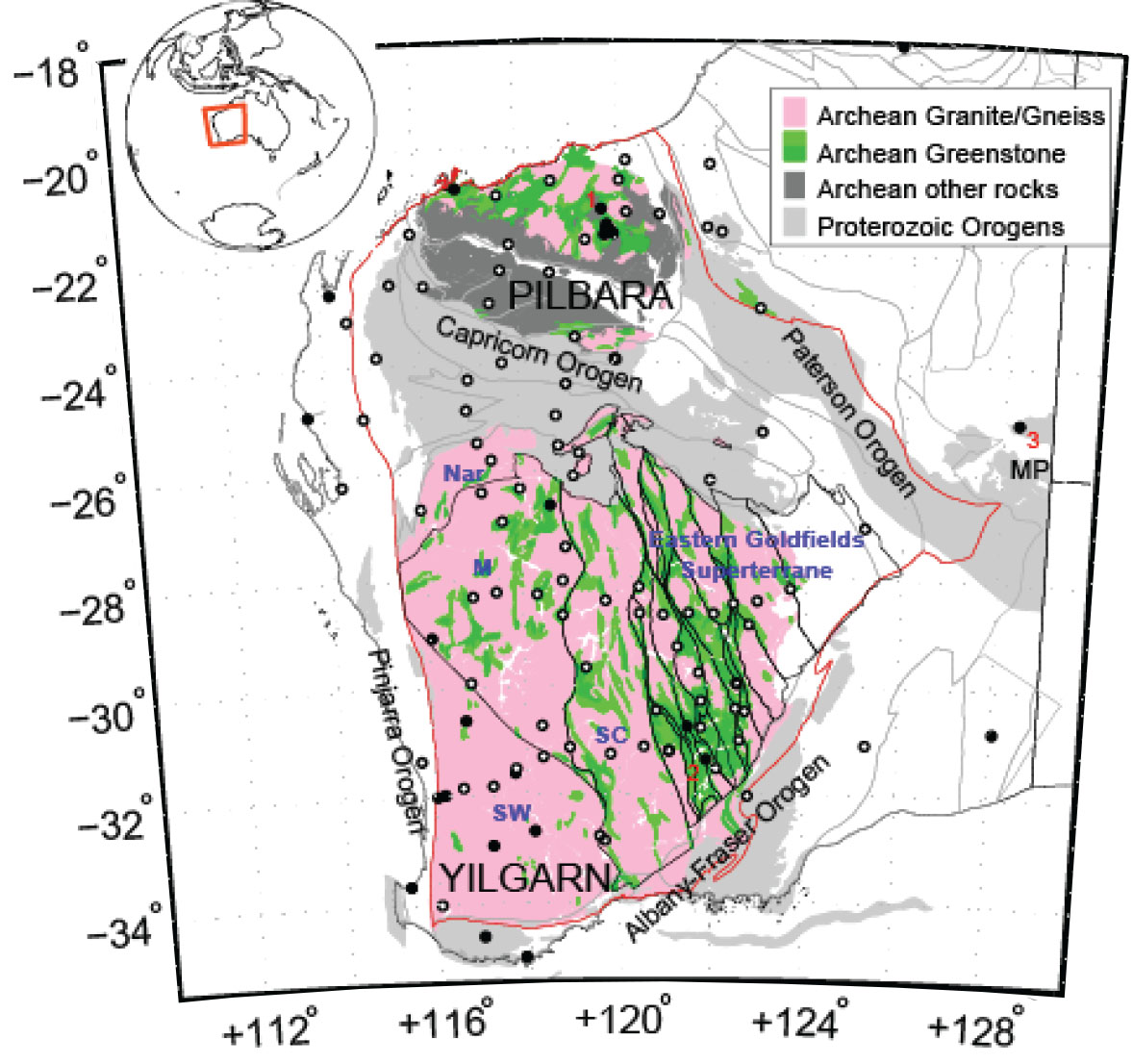
Figure 1. Simplified Archean and Proterozoic rock ages, crustal elements and seismic stations in Western Australia. Inset shows the location of the study region. Greenstone belts are shaded in green. Rock ages and large-scale crustal elements are based on 1:500k State Tectonic units map compiled by the GSWA. Terrane and domain boundaries in the Yilgarn follow Cassidy, et al. 2010. Seismic stations are shown by open (temporary deployment) and filled (permanent) circles. Labels are: Nar, Narryer terrane; M, Murchison domain; SW, Southwest terrane; SC, Southern Cross terrane; and MP, Proterozoic Musgrave Province.
In a manuscript (Yuan, CCFS publication #649) seismic receiver function data were used to analyse the bulk properties of continental crust in Western Australia (Fig. 1), which formed and stabilised over a billion years in the Archean. The analysis shows that the bulk seismic properties of the crust cluster spatially, with similar clusters confined within the boundaries of tectonic terranes (Fig. 2). This spatial clustering of the crustal properties is strongly indicative that these tectonic sub-units may have formed differently through time.
Local Archean crustal growth models suggest that both plume and subduction processes may have had a role in creating crust throughout the Archean. A correlation between crustal age and the bulk seismic properties of the crust reveals a trend: from about 3.5 Ga to the end of the Archean, the crust gradually thickened and simultaneously became more evolved in composition. A similar trend of Archean crustal thickening is also found in a global compilation by Keller and Schoener (Nature, 2012).
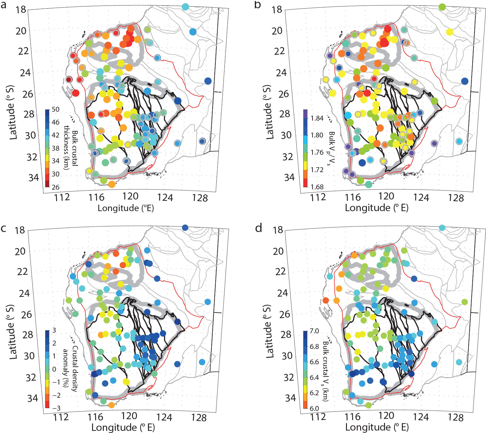
Figure 2. Spatial distribution of the crustal observations in the Western Australian craton. a-d, Bulk crustal thickness (a), Vp=Vs ratio (b), crustal density anomaly (c; Aitken et al., Tectonophysics 609, 467-479, 2013) and composite bulk crustal compressional wave (P-wave) velocity (d). The measurements are colour-coded and plotted at the seismic stations. The WA craton is contoured in red. The subdivisions of WA can be found in Figure 1.
This trend probably reflects the transition between crust dominantly formed above mantle plumes, to crust formed in subduction zones - a transition that may reflect the secular cooling of Earth‘s mantle. Numerical simulations (e.g. Johnson et al., Nature Geoscience, 2014) show that such secular mantle cooling (decreasing mantle potential temperature (Tp), controls the overall efficiency of the Archean lower crustal delamination processes: higher Tp results in rapid and complete removal of the lower crust, while lower Tp makes the removal process less efficient. It is thus likely that the systematic crustal thickening in WA may simply reflect the secular mantle cooling process: more efficient lower crustal removal processes in the hotter Paleoarchean lead to a thin Pilbara crust; towards the end of Archean, the delamination processes gets sluggish and less lower crust is delaminated, resulting in a gradually thickened crust.
The overall efficiency of the lower crustal delamination processes through time can also explain the age-progressive evolution of the WA crustal composition. In the Paleoarchean, the high mantle temperature and radiogenic crust, episodes of plume activity (Van Kranendonk, CCFS publication #492) and delamination-driven melts (Bedard, Geochim. Cosmochim. Acta, 2006) are probably the key to generating the extremely felsic crust found in the Pilbara, by multi-stage crustal fractionation. In the late Archean, if more mafic lower crust is preserved, it would result in a bulk crustal composition that is more intermediate. By this time, crustal growth in WA may be in transition to a horizontal accretion regime. As the mantle cooled, subduction eventually became more dominant in the late Archean (Barley et al., Precambrian Research, 2008 ); the subduction-related new magmas that were added to the continental crust may evolve to more intermediate composition (Christensen and Mooney, Journal of Geophysical Research, 1995).
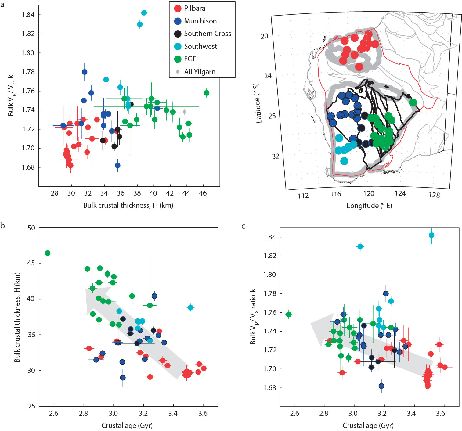
Figure 3. Clustering and temporal variations in the WA crust. a-c, Clustering in the seismic measurements (a), the age correlation of the bulk Vp=Vs ratio (b), and the bulk crustal thickness (c). Stations for each subdivision are marked on the map (inset) and labelled in a. The measurement errors of seismic observations and the errors associated with the isotopic ages are indicated. Note the large deviation of the Southwest terrane and the lack of robust measurements from the Narryer terrane, which are discussed in CCFS Publication 649).
This project is part of CCFS themes 1, 2 and 3, Early Earth, Earth‘s Evolution and Earth Today, and contributes to understanding Earth‘s Architecture.
Contact: Huaiyu Yuan
Funded by: CCFS Flagship Program 7
The geometry and kinematics of hydrothermal vein emplacement in the 3.5 Ga Dresser Formation, North Pole Dome, Western Australia
The 3.5 Ga Dresser Formation in the Pilbara Craton of Western Australia is famous for hosting Earth‘s oldest convincing evidence of life, exposed in the North Pole Dome (see Research highlight pp. 48-49). The Dresser Formation is preserved as a ring of hills, up to 14 km in diameter, and dips shallowly away from the ca 3.46 Ga North Pole Monzogranite that was emplaced to the core of the dome as a sub-volcanic laccolith during eruption of the overlying (ca 3.45 Ga) Panorama Formation.
Figure 1. Dense network of hydrothermal feeder veins to the Dresser Formation in the North Pole Dome.
The Dresser Formation was previously considered to represent a quiet-water, shallow marine environment, but more recent studies suggest it was deposited in an active volcanic caldera floored by an extensive syn-depositional hydrothermal system (Fig. 1). Although the veins representing this system have been recognised as fracture fillings and syn-depositional growth faults (e.g., Nijman et al., Precambrian Research, 1999, 95, 247-274), no kinematic reconstruction of the offsets has previously been attempted. Such a reconstruction can constrain the regional tectonics and associated deformation: was there a regional stress field, or can the veins be related to processes directly related to magma supply and discharge within an evolving caldera system? Is there more than one vein set, and if so how do they relate to the developing caldera?
Figure 2. A) Geological map of part of the Dresser Formation, showing two sets of hydrothermal veins (dark blue and purple) and major structural blocks (A-H). Note that many veins occupy faults that offset bedded cherts (light blue) and volcanic rocks (green). B) Field stations in the study area. White rectangle outlines the area of represented in A.
Answering these questions requires a better view of the structure of veins and their geometry and very detailed field studies of vein networks. This has involved detailed field mapping and structural analysis to define the 3-dimensional geometry of the network and the history of veining and fault-related offsets. In the field mapping phase, we measured approximately 300 veins in the area (Fig. 2; B). Hydrothermal veins were measured for their strike and dip and geographic co-ordinates. As well, cross-cutting relationships between veins were documented where observed, to define the age relationships between the veins. The study area is divided into 10 separate structural blocks whose boundaries are defined by major faults (Fig. 2; A).
The measured veins in each structural block were analysed using the Dips and Stereonet computer programs. This allows determination of the principal orientation of the vein sets, the number of vein sets in each block, and the number of vein systems in the whole of the study area. The measured data were back-rotated to horizontal by un-tilting the bedding, using the Stereonet program Georient. The back-rotated vein data thus represent the orientation of the veins in each structural block before regional tilting (Fig. 3).
Figure 3. A) Measured orientations of veins in Block D. B) Back-rotated data of veins in block D, showing a NW-SE and NE-SW conjugate array of veins in this block prior to tilting. C) Rose Diagram of back-rotated vein data from block D.
This analysis indicates that almost all veins were vertical prior to tilting; therefore, Rose diagrams of each structural block were constructed, in order to identify the main direction of the veins in each block (Fig. 3; C)
The age relationships of the veins sets were studied in order to determine the relationship of the vein sets to regional deformation. The collected data also provide a better understanding of the history of events and geodynamic setting of the Dresser system. This information then will be used to develop a 4-dimensional understanding of the events that accompanied the flourishing of the earliest life on Earth.
This project is part of CCFS Theme 1, Early Earth, and contributes to understanding Earth‘s Architecture and Fluid Fluxes.
Contacts: Sahand Tadbiri, Martin Van Kranendonk
Funded by: CCFS Flagship Program 4
Unravelling the Baoule-Mossi secrets: U-Pb and Lu-Hf studies of detrital zircons from southern Mali, West African Craton
The West African Craton, and in particular its southern portion represented by the Leo Man rise, host a number of world class and base metal systems.
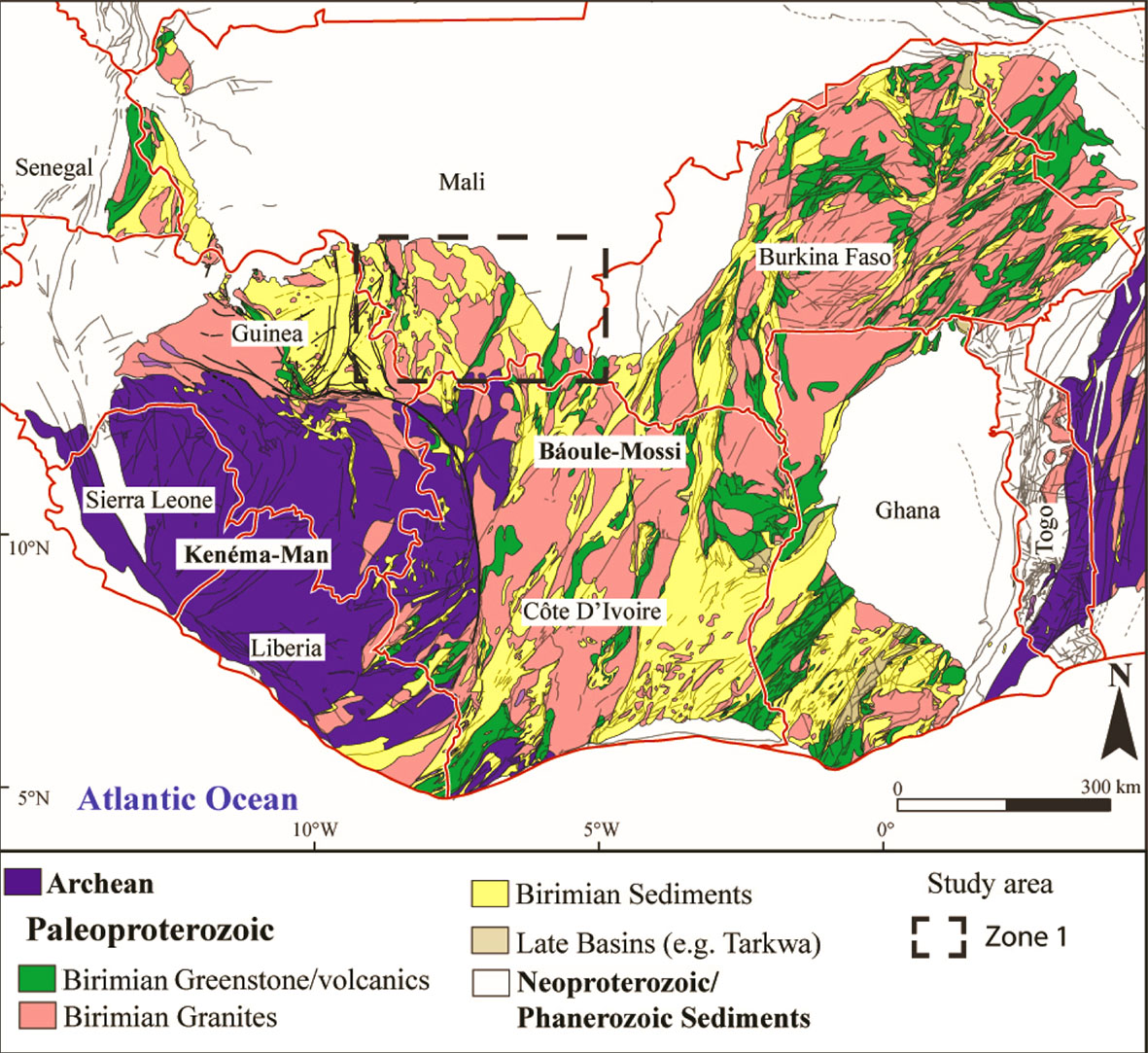
Figure 1. Simplified geological map of the Leo-Man rise (modified after the BRGM SIGAfrique map, (Milési et al., 2004) and the West African Craton (after Gueye et al., 2007).
The Leo Man is divided into the Archean Kénéma-Man in the western portion and the Baoulé-Mossi in the eastern region (Fig. 1). The Kénéma-Man domain is characterised by Archean age rocks and covers large portions of Sierra Leone, Liberia, Côte d‘Ivoire, and Guinea. Its counterpart, the Baoulé-Mossi is characterised by Paleoproterozoic age rocks that are commonly referred to as the Birimian terranes. The Baoulé-Mossi covers most of the geology of Burkina Faso, Ghana, Mali, Niger, Côte d‘Ivoire, and Guinea. The Birimian terranes sensu lato are comprised of relatively narrow volcano-sedimentary basins and linear or/and arcuate volcanic belts known as greenstone belts-basins; associated granitic-felsic intrusive terranes; the contemporaneous or slightly younger sedimentary basins, such as Kuasi, Siguiri, and Sunyani, and the late-basins such as the Tarkwa, and Bui.
Despite the occurrence of a large number of mineral deposits, the region is still poorly understood and subject to much controversy. One of these controversies is the distinction between the Archean and Paleoproterozoic boundaries. It is also believed that the Paleoproterozoic Baoulé-Mossi is the result of mostly juvenile activity with limited interaction with older Archean material. In order to shed light onto the matter, this study analysed zircons collected from small streams, creeks and dry gullies in the area‘s modern drainage system. Zircons were collected from twenty sites across southern Mali covering the Niger and Bani river basins. The Niger River was sampled across 4 sites representing one sub-basin and the Bani River was sampled across eighteen sites representing 8 sub-basins (Fig. 2). A total of 599 zircons from the Niger River and 2254 zircons from the Bani River basin were selected as part of the study. U-Pb analyses were conducted on 295 zircons of the Niger River and 792 zircons of the Bani River, after which 92 zircons of the Niger River and 284 zircons from the Bani River were analysed for Lu-Hf isotopes.
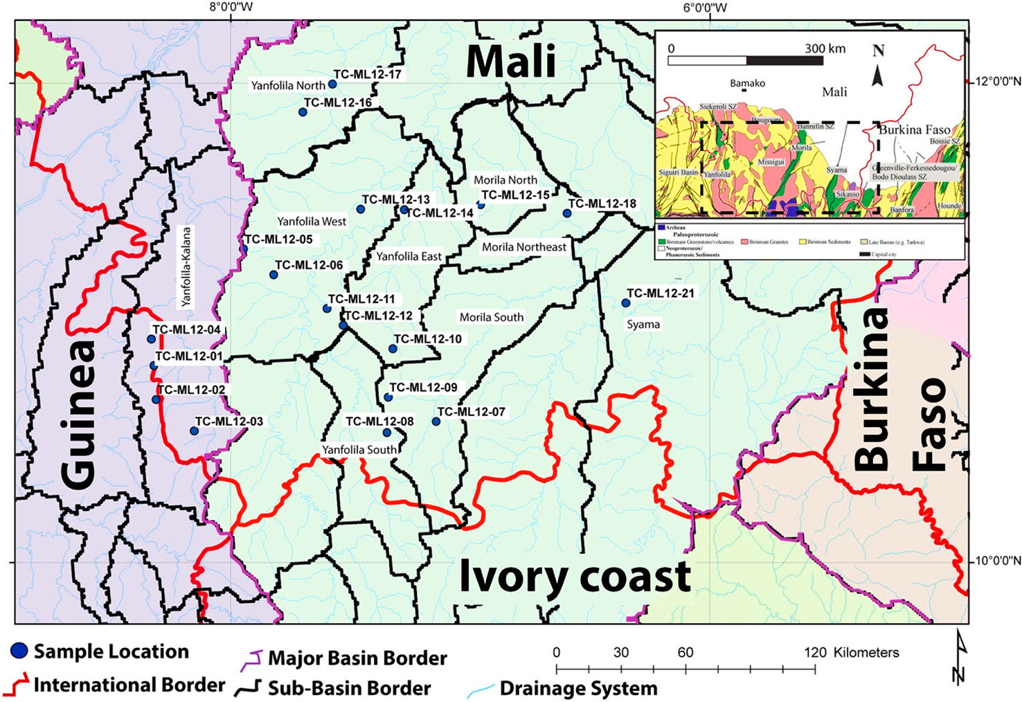
Figure 2. Sample distribution across southern Mali. Purple region represents the Niger River Basin while the light green region corresponds to the Bani River Basin. Basin and sub-basins after Lehner et al., 2006.
The U-Pb results gave Paleoproterozoic ages between 2400 and 2070 Ma. This age range is in agreement with the historical record across southern Mali. These Paleoproterozoic age zircons are considered to be of magmatic origin and show limited metamorphic overprints. They yielded Hf-isotope compositions that indicate model ages between 2800 and 2100 Ma. The spread in Hf-isotope composition points towards a mixing between a juvenile source and a crustal source as old as 2800 Ma.
A second group of zircons yielded U-Pb ages between 3600 and 2100 Ma and Hf model ages between 3600 and 2800 Ma (Fig. 3). This second group presents characteristics that are congruent with long transport due to mostly sub-rounded to rounded crystal morphology. It is also likely that streams and small rivers transported zircons from the Archean Kénéma-Man domain to the Baoulé-Mossi domain because the basin drainage is mainly in a south-southwest to north-northeast direction. Multiple grains were analysed in both rims and suspected inherited cores and showed no variation in ages. Thus, no Proterozoic zircons with Archean age cores have been identified.
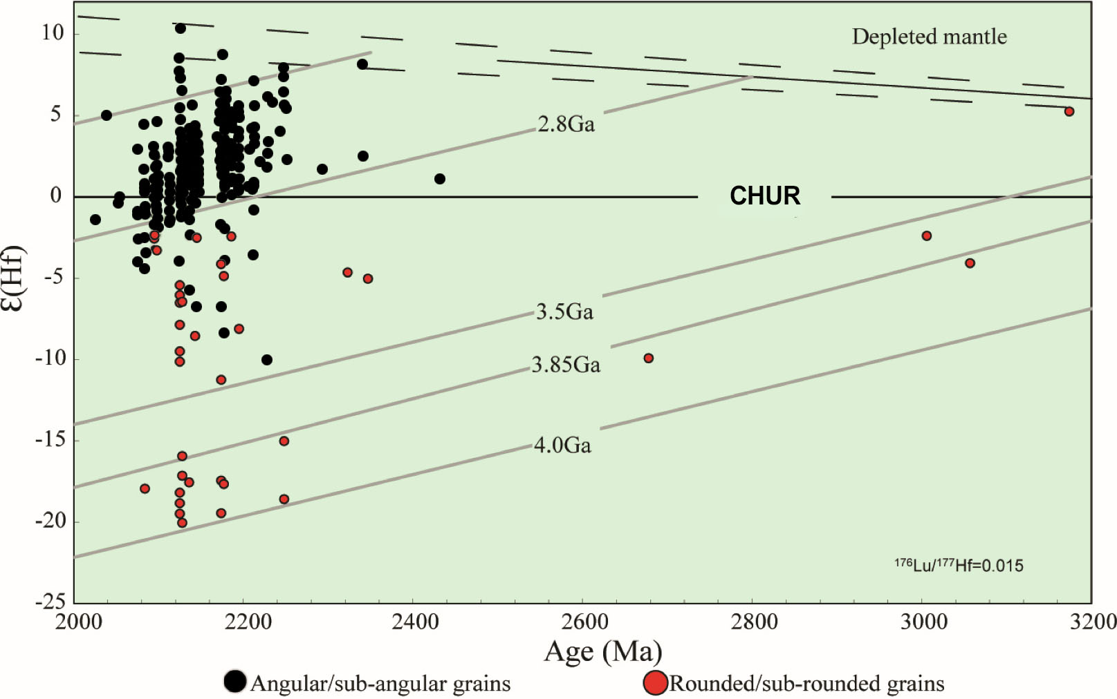
Figure 3. εHf vs. U-Pb age in Ma showing the distribution of the angular to sub-angular grains (black circles) and the sub-rounded to rounded grains (red circles).
The identification of Archean zircons in the region suggests greater interaction between the Baoulé-Mossi and Archean Kénéma-Man domains. Although zircons of the Baoulé-Mossi domain generally confirm its juvenile origin, some of those Paleoproterozoic grains have Hf-isotope composition that indicate reworking of an older crust at a larger scale than previously recognised.
This project is part of CCFS Theme 2, Earth‘s Evolution, and contributes to understanding Earth‘s Architecture.
Contacts: Luis Parra-Avila, Elena Belousova, Marco Fiorentini, Lenka Baratoux, James Davis, John Miller, Cam McCuaig
Funded by: AMIRA International West Africa Exploration Initiative II (WAXI-II) Project (P934A), ARC Linkage Project (LP110100667), Geological Surveys and Departments of Mines in West Africa as sponsors in kind of WAXI; Fiorentini ARC Future Fellowship (FT110100241), CCFS Flagship Program 2
Disequilibrium-induced initial Os isotopic heterogeneity: implications for dating and source tracing
The Re-Os isotopic system has been widely used to date a variety of materials ranging from mafic-ultramafic rocks and sulfides, to black shale, and even oil. Given their chalcophile and siderophile geochemical behaviour, both Re and Os have a strong affinity to trace phases (e.g. sulfides and alloys), and thus their budgets in these rocks are controlled mainly by these trace phases. The unequal distribution of these discrete trace phases (the nugget effect) leads to poor reproducibility of both Re and Os concentrations that limits applications of the isotopic system. However, its effect on the scale of initial Os isotopic heterogeneity is unclear. To clarify these uncertainties, it is necessary to investigate whether homogenisation of the Os isotopic composition was achieved in these rock systems during their formation.
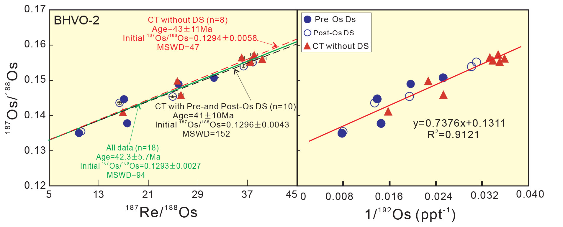
Figure 1. Measured 187Re/188Os vs 187Os/1188Os (a) and inverse of 192Os concentration vs 187Os/188Os (b) for BHVO-2 (true age <100 years). All regressions here were calculated using the program Isoplot 3.00 [Ludwig, 2003]- uncertainties - 2SE. The linear regression equation and R2 value are shown on the diagram here. These good positive covariations suggest binary component mixing.
Replicate analyses of gram aliquots of single basaltic powders (one of reference material BHVO-2 and three of the Hatu basalts from the western Junggar region, China) show large variations in both Os concentrations and isotopic ratios. Duplicate analyses of a single powered whole-rock sample including both Hatu basalts and international reference rock (BHVO-2) defined good apparent Re-Os isochrons and linear trends between 1/192Os vs 187 Os/188Os (Fig. 1 and Fig. 2). These relationships signify disequilibrium-induced small-scale Re-Os heterogeneity and no individual analysis can represent the initial Os isotope composition of the whole-rock sample (their source composition). Because in most cases only one analysis was conducted on 1-2 g of a randomly selected aliquot of powdered whole-rock samples, this study raises the issue of whether an individual analysis can be representative of the source of the whole rock. This is especially true for rock units with large ranges of measured 187Re/188Os and 187Os/188Os ratios.
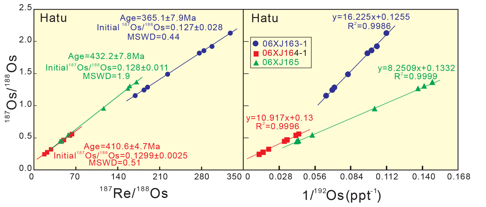
Figure 2. (a) Re-Os isochron diagram for replicate analyses (n = 8) of each of the three Hatu basalts (true age ca 315 Ma). The three samples exhibit three different apparent isochron ages with different initial 187Os/188Os ratios. (b) 187Os/188Os plotted against 1/192Os for replicate analyses of the Hatu basalts. Error bars are shown when bigger than the symbols. All three samples show positive slopes with 06XJ163-1 having a steeper slope.
Apparent Re-Os isochrons can be generated through binary mixing without complete isotopic equilibrium at the time of formation, primarily due to limited diffusional exchange of Os isotopes between refractory Os-bearing inclusions, sulfides, their host minerals and the magma under mantle conditions (Fig. 3). The regressed initial Os isotopic composition may not represent the true value of the mantle source. Thus, when using the Re-Os isotopic system to date and to trace the source of basaltic rocks or other rocks with relatively low Os concentrations, it is necessary to consider whether the initial Os isotopic composition was heterogeneous or whether it had reached complete isotopic equilibrium. The results obtained in this study also pertain to Re-Os dating of low-temperature systems such as black shales, crude oil and bitumen.
Figure 3. Illustration of the cases of binary mixing on the Re-Os isochron diagram, (a) K = 0; the initial Os isotopic ratios of the two mixing components were in equilibrium after diffusion during mixing (or the mixture was derived from a single homogeneous component). The isochron is a conventional isochron (Ap) with initial 187Os/188Os (Ip), and the observed apparent isochron age (tp) is equal to its formation age (t); (b) K ≠ 0; the initial Os isotopic ratios of the two mixing components were not in complete equilibrium after diffusion during mixing. The mixing line (Ap) represents the combination of an initial mixing line (IM) and the ingrowth of 187Os since formation (t). Such an apparent isochron (AP) yields a geologically meaningless age (tp).
This project is part of CCFS Theme 2, Earth‘s Evolution, and contributes to understanding Earth‘s Architecture.
Contacts: Xuan-Ce Wang, Jie Li
Funded by: Wang ARC Future Fellowship (FT140100826), National Natural Science Foundation of China (41173038)
Heaven on Earth: ‘nebular‘ mineral assemblages from Mt Carmel, Israel
The minimum oxygen fugacity (fO2) of Earth‘s upper mantle probably is controlled by metal saturation, as defined by the Iron-Wüstite buffer reaction FeOgFe + O. However, moissanite (SiC) is found in kimberlites worldwide, and an extensive suite of super-reduced minerals, including SiC, alloys and native elements, occurs in peridotite massifs in Tibet and the Polar Urals. These occurrences suggest that more reducing conditions (fO2 = 5-6 log units below IW) must occur locally in the mantle. Unfortunately, these occurrences are known almost entirely from mineral separates, and thus lack spatial mineralogical context.
Figure 1. Left: transmitted-light image of 1-mm corundum grain from Mt Carmel, showing network of melt inclusions within and between corundum crystals. Right: cathodoluminescence image of corundum crystal showing skeletal/hopper growth; dark zones reflect high concentrations of Ti3+ in corundum, and darkest colours are adjacent to melt pockets.
In an ongoing collaborative research project with Shefa Yamim (A.D.M.) Ltd (Akko, Israel), we have found that aggregates of corundum crystals ejected from Cretaceous volcanos on Mt Carmel, North Israel, contain trapped melt pockets (Fig. 1) with high-temperature mineral assemblages that require extremely low fO2 (IW -10). Over 65 different phases have been recognised; half of these have not been described previously as minerals.
Figure 2. Tistarite and TAZ phase in melt pocket; dark matrix is Ca-Al-Si glass with darker quench needles of anorthite; red phase is TiN. Note euhedral corundum crystals forming boundaries to melt pocket.
The corundum crystals show spectacular variation in cathodoluminescence (CL), varying from light pink to dark pink to black, corresponding to a progressive increase in Ti content. Stoichiometry indicates that Ti is present as Ti3+, i.e. a strongly reduced form. The CL images (Fig. 1) and EBSD studies show that most crystals are skeletal and grew as aggregates of hopper crystals, implying rapid crystallisation from melts supersaturated in Al2O3.
The pockets contain four basic types of melts. Type S (silicate), the most abundant, consists of crystalline phases, commonly including tistarite (Ti2O3), set in a matrix dominated by Ca‐Al‐Si‐Ti‐Zr‐K oxides (Fig. 2). This matrix usually is either glass or very finely crystalline; it is amorphous in terms of Raman spectroscopy. Some inclusions show quench structures with radiating blades of anorthite and/or needles of unidentified REE-rich phases in the Ca-Al-Si glass, while in others the matrix has crystallised to an assemblage including anorthite and several undescribed Ca‐K‐Mg‐Al silicates and oxides. None of the silicate or oxide phases in the Type‐S melt pockets contain detectable levels of Fe or Ni.
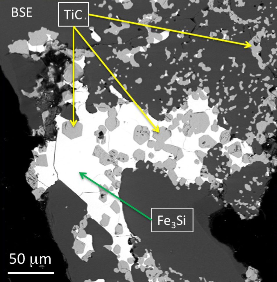
Figure 3. Type A melt pocket between euhedral corundum crystals; TiC crystallising from an Fe-Ti-Si-C melt have been trapped by the growth of the corundum crystals, confining the melt to the interstitial spaces.
Type A (alloy; Fig. 3) pockets were Fe‐Ti‐Si‐C‐P melts, and have crystallised to a range of phases, including gupeiite (Fe3Si), FeTiSi, FeTi and TiC (khamrabaevite). Type N (nitride; Fig. 4) is represented mainly by osbornite (TiN with 12.5-16% N), intergrown with TiB2; the identity of both phases has been confirmed by Dr Martin Saunders (UWA), using TEM electron diffraction. TiO has also been found together with TiN. Type N assemblages commonly occur in complex rectilinear 3‐D networks, which may cross Type S pockets (Fig. 4). Type D (desilicated; Fig. 5) pockets consist of phases with no Si, including native vanadium, grossite (CaAl4O7), hibonite (CaAl12O19) and fluorite.
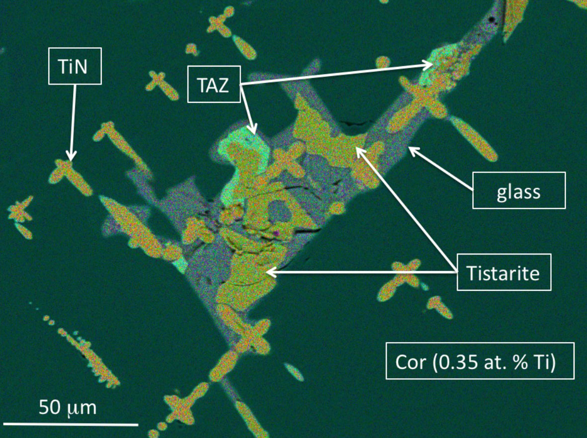
Figure 4. Type S and Type N melts; the TiN appears to fill rectilinear channels in the corundum, related to skeletal growth (Fig. 1).
The textural relationships in and among the melt pockets suggest that the different melts were mutually immiscible. They can be found in different areas of the same inclusion (especially where these are partially necked‐down), and in separate inclusions in the same corundum grain; the apparent separation may simply reflect 2‐D sectioning of complex 3‐D structures (Fig. 1). The presence of glass with quench structures implies that the evolution of the melts was halted by eruption of the host magma. The peritectic crystallisation of corundum+melt g anorthite indicates crystallisation at depths of 30-100 km (i.e. within the lithospheric mantle) and temperatures in excess of 1450 °C. Available experimental data on other phases (usually at 1 atm. pressure) also indicate magmatic temperatures.
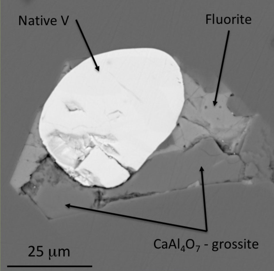
Figure 5. Type D (Si-free) melt pocket with native V, grossite and fluorite.
One of the most abundant phases in the Type S pockets is tistarite (Ti2O3), previously known only as a single grain (associated with TiC and corundum) from the Allende carbonaceous chondrite. These reduced phases are believed to have formed as high-T condensates during the early evolution of the solar nebula, when the fO2 was 10-19, ca 10 log units below the IW buffer (Fig. 6), because the solar wind consisted almost entirely of hydrogen.
Other “nebular” phases in the Mt Carmel assemblage include SiC, grossite, hibonite, osbornite, gupeiite and wassonite (TiS), all typically found in carbonaceous chondrites. Similar high-T, very low-fO2 conditions must have existed locally in the Cretaceous upper mantle beneath Mt Carmel.
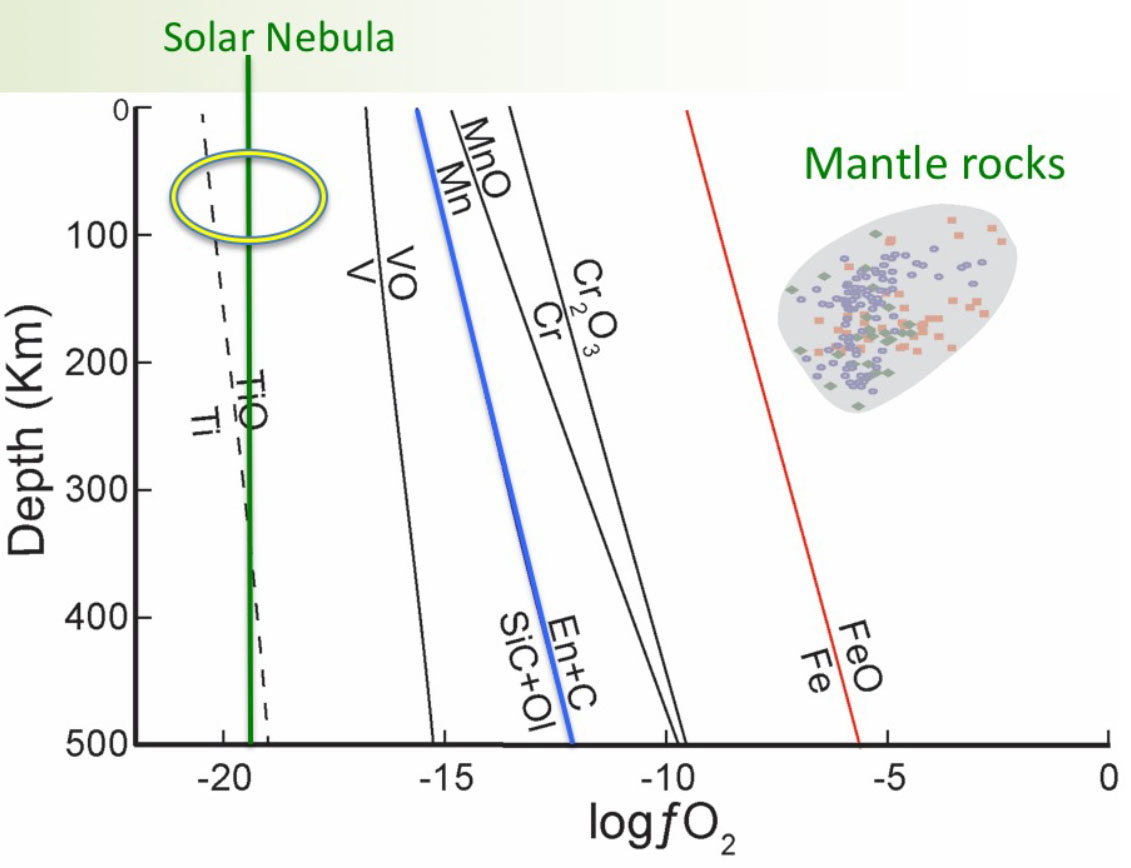
Figure 6. Some fO2 buffer curves relevant to the assemblages in the melt pockets. The final conditions of crystallisation probably lie within the green oval, where fO2 is similar to that in the early solar nebula. The grey field illustrates estimates of fO2 in peridotite xenoliths derived from the lithospheric mantle.
We propose that the development of super‐reducing conditions in Earth‘s upper mantle may reflect the mixing of deep-mantle CH4+H2 fluids with mafic magmas in volcanic plumbing systems. Such mixing can lead to desilication of the magma, oversaturation in Al2O3 and“dumping” of corundum in magma conduits. These remarkable samples represent a mantle environment, and a part of the global carbon cycle, that were previously unrecognised, and a process of fluid transfer that may be much more widespread.
This project is part of CCFS Themes 2 and 3, Earth‘s Evolution and Earth Today, and contributes to understanding Earth‘s Fluid Fluxes.
Contacts: Bill Griffin, Sue O‘Reilly, Norman Pearson
Funded by: CCFS Flagship Program 1
Isotopic mapping of Archaean lithosphere to target orogenic gold and magmatic Cu-Ni-P
Steep penetrating lithospheric structures are pathways for focused mass and energy flow from mantle to crust. Mineralisation emplaced from the mantle into the crust is likely to be distributed along these pathways, a concept supported by empirical associations between mineral systems and lithospheric architecture. A large portion of today‘s continents (<70%) is thought to be underlain by Archaean continental lithospheric mantle, which may have been instrumental in localising much of the mineralisation of its time and in many succeeding events. As high-quality greenfield mineral discoveries decline, mapping the Archaean crust-mantle evolution through time and space has potential to highlight prospective lithosphere and aid in targeting mineral systems.
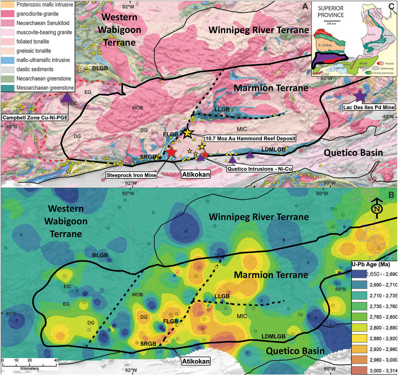
Figure 1. A. Geological map showing terrane boundaries of Stott (2011). Hatched boundaries are significant lithospheric structures. Red boundary is revised by this study. Triangles correspond to mineral occurrences, stars to past-producing mines (gold – yellow, iron – red, Ni-Cu-PGE – violet). B. Contour map based on U-Pb ages compiled from previous workers (mainly by TIMS) and this study by SHRIMP, shown in colour-coded circles corresponding to the colour scheme of the contours. Only ages interpreted as magmatic are included. C. Inset showing the location of the Marmion Terrane (red) within the Wabigoon Superterrane (violet) of the Superior Craton.
Despite a rich geological record of Archaean crust, conditions and geodynamic processes characterising the Archaean remain contentious. Interpretations inferred from petrological, geochemical and geophysical signatures are fraught with the prospect that these signatures reflect overprinting by deformation and metamorphism. An increasingly popular approach to interrogate the crustal record capitalises on the ability of the zircon lattice to concentrate useful radiogenic (Pb, Hf) and stable (O) isotopes and trace elements, and the mineral‘s resistance to subsequent resetting of these systems by tectonothermal reworking.
Results from in situ U Pb geochronology on igneous zircons of the Marmion Terrane (3.02 - 2.68 Ga), Wabigoon Superterrane, Western Superior Craton, Canada help constrain the cryptic growth of the crust across time and space. In conjunction with field-based studies, this has highlighted a shift in geodynamics at ~2.8 Ga, and allows us to explore relationships to mineral system distribution. As a uniquely preserved natural laboratory within the world‘s largest Archaean craton, insights gained here have potential to shed light on global crustal growth and geodynamics.
In the Western Superior, linear east-trending granite greenstone terranes are separated by highly metamorphosed and fault-bounded metasedimentary basins (Fig. 1c). The Marmion Terrane, with a western boundary revised by this study, stands out as the most coherent Mesoarchean block in the Wabigoon Superterrane. Isotopic patterns highlight a northeast-trending structure that is cryptic in the geology (western hatched line, Fig. 1b). Another northeast-trending structure, the Marmion Shear Zone (MSZ) appears to have controlled the significant gold deposits of the terrane (eastern hatched line, Fig. 1b). The focus of later tectonothermal events along these structures supports an interpretation of deep lithospheric structures in a northeast orientation.
Figure 2. Stratigraphic compilation of the Greenstone belts within the Marmion Terrane. Ages are given by red (extrusive) and yellow (detrital) circles. Corresponding plutonic events are illustrated at the left. Age constraints on granitic intrusions are provided by U-Pb geochronology in zircons; blue circles indicate mafic events constrained by U-Pb geochronology in baddeleyite. Timing of mineralisation is constrained stratigraphically (VMS, Fe), by Pd-Pd ages in galena (Au) and by crystallisation ages (Ni-Cu-PGE).
Supracrustal rocks record a significant change across the Meso- to Neoarchaean boundary (Fig. 2). Cyclic tholeiitic volcanism with minor aluminum-undepleted komatiites dominates the 3.02 - 2.82 Ga record and provides evidence for high-degree partial melting of the mantle at depths above 8 GPa. The geochemistry of these rocks is analogous to those of oceanic plateaus, such as the Ontong Java Plateau. After 2.8 Ga the Marmion terrane was uplifted. Conglomerate channels were eroded into the granitic basement, and stromatolitic limestone and iron formations were deposited. Pyroclastic aluminum-depleted komatiite was then deposited, indicating much deeper mantle melting (Fig. 2). The uplift may reflect development of a depleted lithosphere which may be related to subsequent melting at greater depths.
Subsidence was followed by a shift to more calc-alkaline mafic to intermediate volcanism from 2.74 - 2.72 Ga on the southern margin of the terrane, reflecting melting of a fluid-fluxed mantle. Basin inversion accompanied ongoing transpression during the Kenoran orogeny and late Timiskiming-type sedimentation was localised in the synclinal axes of Mesoarchean greenstone belts and along the active southern margin of the terrane at 2.7 Ga. The main gold mineralisation was emplaced in the oldest tonalitic rocks at 2.7 Ga, along the steepest age gradients proximal to the reactivated MSZ and Quetico Fault, which marks the boundary between the Marmion Terrane and the Quetico basin to the south (Fig. 1). Gold mineralisation exploited a long-lived architecture during a time of favourable geodynamics.
This project is part of CCFS Theme 2, Earth‘s Evolution, and contributes to understanding Earth‘s Architecture.
Contacts: Katarina Bjorkman, Cam McCuaig, Yongjun Lu
Funded by: CCFS Flagship Program 2
The Ivrea Zone Pipes: new light on ore-forming processes in the deep continental crust
Our ability to discover new mineral resources is challenged today partly due to the limited predictive capability of the traditional approach based on analogue deposit models. Recently, a new conceptual framework, the mineral system approach, has been proposed, which enables more powerful predictive capability for mineral exploration. This project tests the hypothesis that the genesis of sizeable mineral deposits is the end product of self-organised critical systems operating from the scale of the planet all the way to the very focused environment where ore deposits can form. The mineral system approach represents a step change in the way we investigate ore-forming processes, whereby we look at the evolving relationship between the localised setting of anomalous metal resources and processes operating at the scale of the planet. Prior to the advent of this concept, single deposits were documented in detail as unique occurrences. However, this approach failed to focus on the commonalities among various occurrences and, more importantly, the larger-scale architectural framework that hosts them. The new rationale now takes on a more holistic approach acknowledging that the genesis of mineral occurrences required the conjunction in time and space of three main independent parameters: fertility, lithosphere-scale architecture, and favourable transient geodynamics.
Figure 1. Simplified geological map of the Ivrea-Verbano Zone showing the location of the pipes.
This conceptual framework forms the basis of the present project, which focuses on a series of alkaline mafic-ultramafic pipes, rich in sulfides and hydrous minerals, that intruded the lower continental crust of the Ivrea-Verbano Zone in the Italian Western Alps (Fig. 1). The pipes are relatively small and primarily composed of a matrix of subhedral to anhedral amphibole (pargasite), phlogopite and orthopyroxene that enclose sub-centimetre-sized grains of olivine. The 1 to 5 m-wide rim portions of the pipes locally contain significant blebby and disseminated Fe-Ni-Cu-PGE sulfide mineralisation. Stratigraphic relationships, mineral chemistry, geochemical modelling and phase equilibria suggest that the pipes represent open-ended conduits within a large magmatic plumbing system. The earliest formed pipe rocks were olivine-rich cumulates, which reacted with hydrous melts to produce orthopyroxene, amphibole and phlogopite. Sulfides precipitated as immiscible liquid droplets that were retained within a matrix of silicate crystals and scavenged metals from the percolating hydrous melt, derived by partial melting of a metasomatised continental lithospheric mantle.
Figure 2. Schematic illustrations of the geodynamic evolution that facilitated the genesis of the pipes. (A) Early oceanic subduction in the Eo-Variscan (420-380 Ma) initiating metasomatism of the lithospheric mantle. (B, C) Continental collision and ongoing metasomatism of the lithospheric mantle in the Meso-Variscan (360-310 Ma) create pods of metasomatised mantle (cf. D). (D) End of the continental collision and beginning of the gravitational collapse in the Neo-Variscan (300-280 Ma). (E) Post orogenic collapse, crustal extension and asthenospheric rise cause decompression melting of the lithospheric mantle and initiate the underplating of the continental crust. (F) Further extension and asthenospheric rise cause partial melting of the metasomatised mantle pods, facilitating the intrusion of the pipe magmas into rocks of the upper lithospheric mantle and lower continental crust.
New high-precision chemical abrasion TIMS U-Pb dating of zircons from one of the pipes indicates that these pipes were emplaced at ca 250 Ma, following
partial melting of lithospheric mantle pods that were metasomatised during the Eo-Variscan oceanic to continental subduction (420-310 Ma). The thermal
energy required to generate partial melting of the metasomatised mantle was most likely derived from crustal extension, lithospheric decompression and
subsequent asthenospheric upwelling during the orogenic collapse of the Variscan belt
(< 300 Ma), as shown in Figure 2. If the pipes had been emplaced in an active compressional environment during the Variscan continental collision, as
opposed to the extensional post-orogenic setting constrained through the high-precision geochronology presented in this study, their magmatic plumbing
would have attained self-organising criticality with the establishment of high-flux conduits. This would have led to focused energy and mass flux transfer
from the mantle into the crust, with the potential for the formation of sizeable orthomagmatic deposits, rather than the modest occurrences that actually
formed.
In fact, rather than through a network of self-organised high-flux conduits, mantle-derived magmas trickled through a series of lower-energy pipes, producing a slow and persistent flux of magmas through the interface between the lithospheric mantle and the continental crust. In other words, the magmatic plumbing system that originated the pipes did not self-organise, with the result that high-flux networks were not established and no major ore-forming process occurred. However, even if this process of metal and volatile transfer from the lithospheric mantle to the base of the continental crust is not necessarily conducive to the synchronous genesis of economic mineral deposits, it can be a very effective mechanism to fertilise the notably dry and restitic lower continental crust. Accordingly, even without necessarily generating significant syngenetic Ni-Cu-PGE mineralisation, this process has the potential to add metals and volatiles into the base of the continental crust, thus seeding the ground for the genesis of later mineral systems. This process could represent an effective mechanism to enhance the metal endowment of continental block margins and paleo-margins.
This project is part of CCFS Themes 2 and 3, Earth‘s Evolution and Earth Today and contributes to understanding Earth‘s Architecture and Fluid Fluxes.
Contacts: Marco Fiorentini, Marek Locmelis, Tracy Rushmer, John Adam, Steve Denyszyn, Ricardo Arevalo
Funded by: CCFS Flagship Program 2, Fiorentini ARC Future Fellowship