Research highlights 2011
Moon impacts on origin of Earth and Solar System
Material from the Moon can provide insights into the early history of the solar system and help us to understand the mechanisms of planetary differentiation. On Earth, traces of early differentiation have been erased by tectonic events, whereas the Moon has been relatively inactive for almost 4 billon years. Therefore the Moon provides a unique opportunity to study early differentiation processes on a planetary scale. In addition, the early solar system was affected by intense meteoritic bombardment. The heavily cratered surface of the Moon testifies to this bombardment, which is still ongoing. Evidence of the early bombardment is difficult to find as the lunar surface is continuously reshaped and modified by the influx of meteorites. One source of information is old grains of zircon, which can be extracted from lunar rocks and soils.
Lunar zircons are useful because they can give information about both differentiation (as they crystallised in deep-seated plutonic bodies) and impact processes. They are not easily destroyed by impact metamorphism, but often carry signs of partial reworking during the impacts. They are found in impact melt breccias, which are rocks composed of pieces of broken rocks, loose minerals (or pieces of broken minerals) set in a matrix made up of crystallised impact melt. Zircons found in thin sections are imaged using an optical microscope and then a scanning electronic microscope (SEM) to reveal their internal features (Fig. 1). They are then dated in situ by the U-Pb technique using an ion microprobe: this allows us to target specific areas of the zircon grains and extract ages related either to magmatic events or impact deformation.

Figure 1. Images of zircon grain 73235-59#3 (the tiger).
One special zircon grain, nicknamed “Tiger” because of its striped appearance, shows several features that are often observed in lunar zircons and are especially significanct for the interpretation of their history. The stripes are Planar Deformation Features (or PDFs) corresponding to defects in the crystalline lattice that can only be created at the very high pressures generated by an impact. These PDFs are visible in the optical microscope (Fig. 1a) and with the SEM. In addition, the zircon grain is plastically deformed, testifying to deformation that occured during the heating generated by the impact (Fig. 1c). The Tiger grain also shows some recrystallised areas (Fig. 1 arrows); as no fluids are known to be available on the Moon, these recrystallised zones probably were generated following changes induced by an impact. These recrystallised zones in lunar zircon provide a unique way of dating the impact that generated them. In the case of the Tiger grain, the area is large enough to fit an ion probe spot on it. This zone proved to be ~250 million years younger than the main part of the zircon, which records the time of the zircon’s original crystallisation from the melt (Fig. 2).

This study shows that many zircon grains can be used to determine both the time of their magmatic crystallisation and the timing of their modification by impacts. Study of the relationships between different impact features preserved in some grains allows us to reconstruct the P-T paths followed by these grains in the immediate aftermath of the impact. We hope that in the future we will be able to use this information to link individual zircon grains to specific impact craters on the Moon and determine from which part of the crater this zircon was excavated. For more of this story, see CCFS Publications #126 and 147.
Contacts: Alexander Nemchin, Marion Grange
Funded by: CCFS, Curtin University and ARC Discovery (form 2012)
Figure 2. Concordia plot showing ages of primary zircon (filled symbols) and PDFs.
Sulfur in unique ancient Australian rocks may unlock Earth and life secrets

Figure 1. The global SMIF database 2010 showing the first significant Mesoarchean positive SMIF data from the margins of the first stable cratons. (Halvey et al. 2010, Science).
The relationship between the evolution of Earth’s atmosphere and hydrosphere during the Archean, and the beginning of life are major questions in Earth Science. The mass-independent fractionation (MIF) of sulfur isotopes (expressed as δ34S, Δ33S and Δ36S) was caused by ultraviolet photolysis of atmospheric SO2 in the Archean when the atmosphere was oxygen-poor and the ocean was sulfur-poor. There are significant variations in the degree of mass-independent fractionation during the Archean; it was lowest in the Mesoarchean (from 3.3 to 2.8 Ga), and these variations carry very important information. This low point has been suggested to be a result of an early rise in atmospheric oxygen. However, more recent studies (Farquar et al., 2007 Nature) show there is no clear evidence that oxygen rose then.

Figure 2. Neoarchean komatiite hosted Ni sulfide deposits where we have obtained S-MIF data to define the source of sulfur linked to volcanic massive sulfide (VMS) deposits with negative S-MIF data (Bekker et al., Science 2009, 326).
The strongest Mesoarchean Δ33S MIF values ranged from -0.13 to 1.31 between 2.96 Ga and 2.9 Ga (Fig. 1); this coincides with the only major volcanic events during this period, after the stabilisation of the first cratons (Kaapvaal and Pilbara). These events are linked to the start of plate tectonics and subduction (from 3.1 to 2.95 Ga), which poured volcanic gasses into the atmosphere, contributing to the development of sulfur isotope MIF and the high levels of Mesoarchean sulfur. Prior to 2.7 Ga there is a very limited rock record, and most samples showing sulfur MIF from the Mesoarchean are from continental-margin sedimentary ocean basins on the two new cratons; therefore the lack of significant negative Δ33S values is not really evidence for oceanic sulfate (or atmospheric oxygen) during this period.

Figure 3. Similar-looking komatiite hosted Ni Sulfide deposits, with adjacent VMS deposits and banded iron formations, where we have found the only significant Mesoarchean negative S-MIF data.
Those samples show key evidence for variations in the sulfur cycle through this time range, rather than just minor oxygen-fugacity variations before the Great Oxidation Event (Figs. 2-4). However, the ~2.9 Ga Lake Johnston Greenstone belt in the Yilgarn Craton is a marine rift with submarine volcanic rocks (basalts, felsic volcanics and komatiites) shales and banded iron formations (BIFs); it also contains low-temperature volcanogenic massive sulfides (VMS) and the Maggie Hays komatiite-hosted Ni sulfide deposit. The new Δ33S values we recently obtained from a key set of samples from this belt range from -1.7 to 0.1, providing the first and only strongly negative Δ33S data from the Mesoarchean. These observations are consistent with the reduction of inorganic sulfate, similar to that observed in the Neoarchean VMS, komatiite-hosted Ni sulfides (Figs. 2, 3 and 4) and BIFs. This provides the only evidence for a Mesoarchean sulfate reservoir linked to a subaerial volcanic plume and an oceanic volcanic plume with volcanic island eruptions. These data show that the strongest positive and negative Δ33S variations in the Mesoarchean sulfur MIF record are lower than the range of sulfur MIF variations in the Paleoarchean and Neoarchean. They are linked to the only preserved evidence for Measoarchean Large Igneous Province volcanic events with some subaerial volcanism producing the key volcanic gas. Our new data from the largest 2.95 Ga Mesoarchean deep submarine volcanic massive sulfide deposit, Golden Grove, are evidence for major suphur recycling after plate tectonics started.

Contacts: Mark Barley, Marco Fiorentini
Funded by: ARC Discovery (initial work until relinquished in early 2011) and CCFS Foundation Research Project 5
Figure 4. Our 2.9 Ga Lake Johnson SMIF data from Maggie Hays compared to our first 2.7 Ga Neoarchean data.
Minute but noble mineral grains yield insights into mantle processes
Pods of monomineralic chromite (chromitites) often occur in the zone between the mantle and the crustal sections of ophiolites, pieces of oceanic lithosphere that were emplaced on land during the closure of oceanic basins. These “podiform chromitites” usually contain high levels of the platinum-group elements (PGE: Os, Ir, Ru, Rh, Pt, Pd). The PGE concentrate in mantle rocks and minerals, and can be used to trace the mechanism of mass transfer between the upper mantle and the crust, and the recycling of crust into the mantle. Podiform chromitites are of particular interest since they tend to concentrate the most incompatible PGE (i.e. Os, Ir, Ru), which are found as minute inclusions of platinum-group minerals (PGM) made up mostly of these elements [e.g. Os-Ir alloys; erlichmanite (OsS2), osarsite (OsAsS), laurite (Ru, Os)S2].

The development of micro-analytical techniques of laser ablation at CCFS enables measurement of Re-Os isotopes in situ on single grains of PGM ~5 µm across. The application of this approach to primary PGM inclusions in podiform chromitites from the Mayarí-Baracoa Ophiolitic Belt (eastern Cuba) has let us decipher heterogeneities in 187Os/188Os at the km, hand-sample, thin-section, and even single-grain scales (Fig. 1). These observations lead directly to the conclusion that the observed Os-isotope heterogeneity in PGM reflects the presence in the upper mantle of melts derived from rock volumes with widely varying Os-isotope composition, perhaps even bodies of ancient subducted crust. This isotopic heterogeneity also suggests that the Os-isotope compositions of PGM hosted in the podiform chromitites may be representative of the large volumes of the convecting mantle that would need to be melted to accumulate these concentrations of Cr and PGEs (see CCFS Publication #13).
However, podiform chromitites, like their mantle-derived host rocks (i.e. dunite, harzburgite, lherzolite), can be altered by fluids during post-magmatic events, such as serpentinisation or metamorphism. During these processes the PGM can be released and exposed to the circulating solutions as the host chromite reacts. Pre-existing PGM may be partially or completely replaced by secondary PGM (e.g. sulfides reduced to alloys or oxides; Fig. 2) and/or new secondary PGM can be formed, stable at the conditions imposed by the alteration. The in situ laser ablation analysis of PGM from metamorphosed chromitites in Bulgaria (CCFS Publication #42) reveals that primary PGM hosted in unaltered chromite are isotopically different from secondary PGM related to the metamorphic overprint (Fig. 2).
These differences between primary and secondary PGM indicates that a significant part of the Os-isotope heterogeneity described in many PGM suites, and interpreted to be mantle-derived, is actually due to post-magmatic disturbance by hydrothermal processes. The fact that secondary PGM in the metamorphosed chromitites of Dobromirtsi yield 187Os/188Os within the range of depleted to enriched mantle sources suggests that much of the Os-isotopic variability previously reported for PGM taken out of their microstructural setting (e.g. mineral concentrates or detrital grains collected from streams), and interpreted as a magmatic feature, may instead be related to secondary alteration processes. Therefore, interpretations of mantle events based on the in situ analysis of PGM nuggets from placers may be need to be re-considered. Moreover, the observation that metamorphosed chromitites may carry primary and secondary PGM with very distinct 187Os/188Os suggests that previously reported Os-isotope compositions of metamorphosed chromitites, which were determined using whole-rock analysis, might reflect mixing of primary (magmatic) and secondary Os remobilised during metamorphism, rather than primary magmatic values.
Once again, in situ microanalysis is providing insights impossible to derive from bulk analysis – and providing grounds for caution about our understanding of some mantle processes!
Contacts: José María González-Jiménez, Bill Griffin, Norman Pearson, Sue O’Reilly
Funded by: ARC, CCFS Foundation Project

Figure 2. Isotopic heterogeneity in PGM suites. TMA model ages of primary (a) and secondary (b) PGM grains from the Dobromirtsi chromitites. Photos are backscattered electron images of primary PGM (c) hosted in unaltered chromite, and altered (secondary) PGM (d, e) found in altered zones of the chromitites. Note scale bars - these are tiny, but analysable, grains.
A window of opportunity for plate tectonics?
Plate tectonics is the machine that shapes the Earth’s surface, from mountain ranges to ocean depths. It is the cornerstone of modern geology, yet it appears that the process only occurs on one known planet - Earth. Additionally, a serious debate continues as to when plate tectonics started on Earth - current estimates range from over 4.4 billion years ago - almost the age of the planet - to just one billion years ago – geologically speaking, our recent past.
It is fairly well accepted that as a planet cools, and its lithosphere - the strong, outer layer that carries the crust - gets thicker, the planet will develop a stagnant “lid”. This is defined by the end of active surface tectonics on a planet. Mars, the Moon, and Mercury all seem to have passed into this twilight regime. However, recent work at CCFS/GEMOC has indicated that stagnant-lid tectonics can operate at the other end of the spectrum, too. For extremely hot planets, the high interior temperatures result in low internal viscosities. This breaks down the coupling between the convecting mantle and the plates, and tectonics again becomes unsustainable. A type example of this sort of hot stagnant lid model could be Io, the most volcanically active planetary body in the solar system.
This model predicts an evolution in tectonics over the course of a planet’s slow cooling, from a hot stagnant mode in its early history, to an active tectonic regime, waning into a cold stagnant mode as the planet ages. Recent simulations at CCFS/GEMOC, presented at the American Geophysical Union meeting in December 2011, confirm this evolutionary trend. These models for the first time incorporated not only the decay in heat production in the mantle through time, but also realistically-evolving conditions in the core of the planet. The starting conditions were the results from equilibrium convection simulations under Hadean thermal conditions. These models commonly showed an evolution from hot stagnant behaviour initially, to an episodic subduction mode, where periods of quiescence are interspersed with periods of rapid, violent subduction.

This progressed into a steadier plate tectonic mode, under mantle conditions similar to today. Eventually the lithosphere thickened beyond the point of sustainable surface behaviour, and the system progressed into a cold stagnant-lid regime. The exact timing and progress depend strongly on the simulation parameters and the initial conditions chosen. However, the results confirm that rather than an end-member tectonic regime, plate tectonics is a phase in a planet’s tectonothermal evolution - which has large implications for exosolar planetary conditions.
Contact: Craig O’Neill
Funded by: ARC Discovery, Future Fellowship, MQ
Did the Earth start off without plates?
Tracking water in the Earth’s mantle

Water is a very efficient fluxing agent, and is likely to have a strong influence on both the distribution and styles of melting within the Earth’s mantle. Knowledge about its distribution and behaviour is critical for our understanding of geochemical fractionation within the Earth’s mantle. However, other factors, including pressure and temperature, are also critical because the effects of water in real magmas can be difficult to distinguish from those produced by P and T. To unravel these effects, we have compared the compositional and structural properties of clinopyroxene (an important mantle phase) crystallised from both water-rich and water-poor magmas.
Figure 1. Experimentally grown crystals of dark green clinopyroxene and brown garnet in a quenched, hydrous, basanite melt. The experiment was conducted at 1190 ºC and 3.5 GPa.
High-pressure experiments have been performed at 1.0-3.5 GPa and 1025-1190 ºC on a hydrous, intraplate magma (nepheline-basanite). Water contents ranging from 5.8 to 16.3 wt % were dissolved in the co-existing melts. Clinopyroxenes (Fig. 1) crystallised from these hydrous experiments were analysed for major elements using an electron microprobe at the GEMOC Analytical Facility. Crystal-chemical structural data for the these pyroxenes, including structure refinements and lattice parameters, were obtained by Fernando Camera and Roberta Oberti using single-crystal X-ray diffractometry at the CNR-Institute of Geoscience and Georesources, University of Pavia, Italy. Water concentrations in the melts were estimated from mass balances between run products and starting materials.
Increasing pressure of formation has a marked effect on both the compositions and structural properties of the clinopyroxenes crystallised from the hydrous melts. Crystals become more jadeite-rich (NaAlSi2O6) but less calcic and Ti-rich as pressures of synthesis increase. These changes are accompanied by a systematic decrease in cell volumes. Higher temperature causes increases in both the clino-enstatite/clino-ferrosalite components ((Mg, Fe)2SiO6) and the Ca-Tschermaks component (CaAl.AlSiO6). Inclusion of these latter components also reduces cell volumes.
We evaluated the effects of H2O by applying the single-crystal clinopyroxene barometer of Nimis and Ulmer (Contrib. Mineral. Petrol., 133: 122-135, 1998) to our data. This barometer is based on the overall response of the crystal structure (principally cell volume) to pressure, rather than to specific compositional changes. It was also calibrated primarily for anhydrous melt compositions. When applied to our data, the Nimis and Ulmer barometer systematically underestimates the pressures of synthesis, and the underestimation increases at higher pressure. This is due to the comparatively large volumes of the crystals grown in our experiments. Thus at constant pressure, clinopyroxenes crystallised from H2O-rich melts have larger volumes than those crystallised from equivalent anhydrous systems. At least in part, this can be attributed to the effects of H2O on the activity coefficients of pyroxene-forming melt components such as jadeite (Fig. 2). When compared to anhydrous experiments, the data also reflect changes in the activity coefficients of components within the clinopyroxene crystal structure (e.g. Tschermaks, clino-enstatite and clino-ferrosalite) caused by the lower temperatures of the hydrous experiments. Further work is underway to evaluate these effects quantitatively and link them to water concentrations in mantle-derived hydrous magmas.
Contacts: John Adam, Trevor Green, Tracy Rushmer
Funded by: Macquarie University Development Grant, ARC Discovery, MQ
Figure 2. The effect of water on the partitioning of sodium between clinopyroxene and melt. The vertical axis shows the ratios of measured partition coefficients for hydrous melts and values calculated for anhydrous melts.
Coupling, decoupling and fluid infiltration: a torrid history of crust-mantle relationships beneath NW Spitsbergen 
Figure 1. A) Map of the Bockfjord area, with the BB fault nd volcano locations. B) Regional setting, showing possible remnants of Spitsbergen lithosphere on the Yermak Plateau.
The Bockfjord area of NW Spitsbergen (Norwegian Arctic; Fig. 1) exposes a long history of crustal evolution, ending in the Caledonian (400-500 Ma) orogeny; prior to the opening of the North Atlantic Ocean, this area was part of the Laurentian (Greenland) side of the orogen. The N-striking Breibogen-Bockfjord (BB) fault marks the western margin of a large graben filled with Devonian redbeds (Fig. 2). West of the fault the basement consists of gneisses, schists and granites of the Hekla Hoek formation, apparently a Caldeonian thrust sheet. U-Pb and Hf-isotope data for detrital zircons from this area show that the protoliths of the Hekla Hoek rocks formed ca 1.8 Ga ago, but were heavily reworked ca 800-1000 Ma ago, and again during the Caledonian orogeny.

Figure 2. Redbeds along Bockfjord.
 Figure 3. Sverrefjell.
Quaternary alkali-basalt volcanism has provided abundant xenoliths of mantle and crustal rocks from both sides of the BB fault. Sverrefjell, a large (but glaciated) cinder cone (Fig. 3) may be the world’s single largest source of mantle- and crustally-derived xenoliths, with an estimated volume of about one-third of a cubic kilometer. Lower-crustal xenoliths are mainly mafic to intermediate granulites. Most zircons from eight xenoliths have Neoarchean/Paleoproterozoic and Paleozoic U-Pb ages; several also contain zircons with ages and/or Hf model ages >3.2 Ga.
The peridotite xenoliths are mainly spinel lherzolites, metasomatised to varying extents. Xenoliths from basalts east of the BB fault commonly contain amphibole, phlogopite and apatite; peridotites from west of the fault rarely have these metasomatic phases. In situ Re-Os isotope analysis of sulfides in the peridotites shows another dichotomy. Xenoliths from west of the fault contain sulfides with Re depletion (TRD) model ages extending back to 3.3 Ga, with major populations at 2.4-2.6 Ga, 1.6-1.8 Ga and 1.2-1.3 Ga (Fig. 4); the Caledonian orogeny is only weakly represented. East of the BB fault the peaks in the TRD spectrum are at 900-1100 Ma and 400-500 Ma; only a few grains have TMA >2.5 Ga.

The data show a major disjunct, on both sides of the BB fault, between the Archean lower crust and a Proterozoic-Paleozoic upper crust; this suggests that the original Archean upper (and middle?) crust was detached and replaced by thrust sheets of younger material during the Caledonian orogeny (Fig. 5). The striking differences in the sub-continental lithospheric mantle (SCLM) across the BB fault suggest that major transcurrent movement has juxtaposed lithospheric sections that evolved independently. This may have happened during the long transport of these terranes from north of Greenland, during the opening of the Arctic Sea.
Figure 4. Distribution of Os model ages of sulfides in peridotite xenoliths from either side of the BB fault.
West of the BB fault, the presence of Archean lower crust overlying Archean SCLM suggests that the crust and mantle have remained coupled for ≥3 Ga. East of the fault, similar Archean lower crust overlies an apparently younger, more fertile SCLM. The pervasive melt-related metasomatism that refertilised the SCLM east of the BB fault may have obscured its Archean origin.

Typical Archean SCLM is 150-250 km thick, whereas the Bockfjord volcanoes carry no samples from deeper than 80 km. The detached lower part of the Archean SCLM may now lie beneath the Gakkel Ridge to the NW (Fig. 1A), as proposed by Goldstein et al. (2008) on the basis of basalt geochemistry. This proposition is supported by the mean TRD of the Sverrefjell sulfides (1740±718 Ma), which is similar to the oldest whole-rock TRD values for peridotites dredged from the Gakkel Ridge (1.8-2.2 Ga; Liu et al., 2010).
Contacts: Bill Griffin, Sue O’Reilly, Norman Pearson
Funded by: ARC and GEMOC, CCFS Foundation Project
Remaking an old continent - A 40° twist between northern and southern Australia 600 million years ago
The basement rocks beneath the western two-thirds of Australia are mostly older than 1800 million years old (Ma) and host the vast majority of Australia’s mineral wealth; the eastern one-third is younger than 540 Ma (Fig. 1). It has long been assumed that the older part of the continent has been in its present-day shape for at least 1000 Ma. However, a re-examination of the tiny magnetic needles trapped in some of Australia’s old rocks has revealed a previously unknown 40° twist between the continent’s two halves some 600 million years ago (Fig. 2).
Palaeomagnetism is a research method that measures the orientation of tiny magnetic particles trapped in rocks. These act as a fossil compass that records the movement of each continent on the Earth’s surface in the deep past. Such fossil magnetic records, called apparent polar wander paths, work like a magnetic barcode for each continent or a piece of a continent. When two pieces of continent travel together on the Earth’s surface, their bar codes match exactly. If the two continental pieces later moved apart, their previous palaeomagnetic ‘barcodes’ would split. This allows us to detect when continents joined together, when they broke apart, and how they moved relative to each other and to the geographic North Pole (Earth’s rotation axis).

Figure 1. A cartoon of the mighty east-west trending mountain range formed between 650-550 million years ago placed on the present-day Australian landscape. Sediments shed from the northern slope of the mountains formed Uluru (Ayers Rock) and Kata Tjuta (The Olgas).
During a reanalysis of geological and palaeomagnetic data from Australia, we noticed that the palaeomagnetic ‘bar codes’ (i.e., apparent polar wander paths) between the northern and southern halves of the old Australian continent share comparable shapes but with a systematic offset in their present-day continental configuration. However, this offset disappears if we rotate southern Australia about 40° relative to northern Australia (Fig. 2a).
This disjunction between the two halves of the old Australian continent coincides with traces of a major 650–550 Ma mountain belt, which runs from the Paterson Ranges off the eastern boundary of the Pilbara to the Petermann and Musgrave ranges of Central Australia, and disappears into central Queensland (Figs. 1, 2b). This east-west trending zone probably was a mighty mountain range, comparable to the Tianshan ranges in central Asia. There are webs of locally molten rocks in the Musgrave Ranges (Fig. 1) caused by large earthquakes that occurred during this major upheaval. The rotation event would also have laterally offset the northern and southern halves of the old continent by over 500 km, and would provide a setting for forming new mineral deposits. Sediments shed off the northern slope of this mighty mountain range formed the present-day cultural and landscape icons, Uluru (Ayers Rock) and Kata Tjuta (The Olgas) (Fig. 1).
Australia probably lost a bit of real-estate during this event, as land that used to fill in the narrow triangular gap in the western part of the continent was probably squeezed out to the west during the rotation. However, Australia did gain in mineral endowment, such as the large Telfer gold deposit in Western Australia. There is potential for finding more such deposits along this long mountain belt. This new interpretation also solves one of the long-standing puzzles about where the southern extension of the Mt Isa mineral zone went. Our work indicates that the two mineral belts may indeed, as previously speculated by geologists, have formed as parts of a single belt that was cut into two halves and offset by over 500 km during an intracontinental rotation some 650–550 million years ago (Figs. 1 and 2).
Our new geotectonic model also resolves a longstanding controversy surrounding the configuration and breakup history of the supercontinent Rodinia (lifespan ca 900–700 Ma), consisting of almost all continents that existed at the time. It implies that Rodinia didn’t break up until much later than we thought, placing the breakup much closer to the time of the hypothesised first ‘Snowball Earth’ event. This makes it more plausible that the breakup of the supercontinent and accompanying geographical and chemical changes led to catastrophic global chilling events (opposite to global warming events) between 750 and 600 million years ago. Both events probably played roles in the Cambrian explosion of complex life on Earth. The formation and subsequent erosion of the mighty mountain range across Australia may also have contributed to the oxygenation of the atmosphere, thus making the Earth more habitable for complex life.

Contacts: Zheng-Xiang Li, David A.D. Evans (Yale University)
Funded by: ARC Discovery
Arkansas was built over collision zone of Archean microcontinents
The upper crust across the southern half of North America consists of a series of Proterozoic orogenic belts (Fig. 1: the 1.6-1.8 Ga Yavapai and Mazatzal terranes, the 1.5-1.3 Ga Granite-Rhyolite Province, the 1.3-1.0 Ga Grenville Province, and finally the Phanerozoic Appalachian belt) successively accreted onto the Archean continental core. This pattern suggests a simple concentric growth of the continent over about a billion years. However, the seismic tomography in Figure 1 suggests that the situation is more complex – high-velocity anomalies like those typically associated with Archean continental roots are visible in a wide band stretching southward from the Canadian Shield. Although these anomalies become less prominent to the south, they are still obvious down to the Gulf of Mexico. What is high-velocity lithospheric mantle doing under young orogenic belts? Unfortunately, there are no volcanic rocks that sample the high-veolcity mantle, and the few that have intruded along the edges of the high-velocity volumes (Fig. 1) rarely carry xenoliths that could reveal the nature of the subcontinental lithospheric mantle (SCLM).
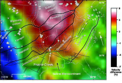 Figure 1. Seismic tomographic image (100-175 km depth slice, courtesy of Steve Grand) covering part of southern North America. The image highlights the spatial relationship between shear wave velocity (Vs) and crustal features. Reference velocity is 4.5 km/sec. “Hot” colours represent high Vs, while “cold” colours represent low Vs.
The Prairie Creek lamproite field is indicated by an arrow. Solid thick black lines are crustal province boundaries of Whitmeyer and Karlstrom (2007). Short black dashes show the interpreted northwestern extent of Grenville lithospheric reworking. Green line shows approximate outline of the Sabine microcontinent, which is surrounded on its west, north and northeast sides by the Ouachita orogen thrust front. Ticked thin black lines are Late Neoproterozoic to Cambrian aulocogens. Thin black lines are the proposed latest Neoproterozoic rifts and transform faults for southernmost Laurentia (Thomas, 2006). Solid red line is the approximate northern extent of Ouachita Orogen thrusts. Long-dashed lines are contours of Phanerozoic sediment thickness (km indicated). Dots are kimberlites and lamproites, and asterisks are Quaternary volcanoes.
The Cretaceous Prairie Creek - Twin Knobs lamproites of southern Arkansas intrude Proterozoic crust near the boundary between the Granite-Rhyolite Province and the Grenville orogen. On the seismic tomography, they lie along the boundary between two blocks of high-velocity mantle. They carry xenocrysts and rare xenoliths derived from the SCLM and the deep crust; these were studied by Dr David Dunn for his PhD thesis, and he has collaborated with us to find out more about them. U-Pb dating of groundmass perovskite in the Prairie Creek lamproites gives a poorly constrained Cretaceous age, consistent with local stratigraphy. U-Pb dating and in situ Sr and Nd isotope data show that perovskite micronodules in the Twin Knobs 2 lamprophyre are ca 600 Ma old, and may represent samples of older rift-related alkalic magmas derived from a juvenile mantle. A lithologic section constructed from mantle-derived garnet xenocrysts (Fig. 2) shows a moderately depleted SCLM that has experienced a high degree of melt-related metasomatism, especially in the depth range 150-140 km. In situ Re-Os analysis of sulfide grains in the xenoliths (Fig. 3) yields model ages ranging up to 3.4 Ga, with major peaks at 1.4-1.5 Ga and 200-300 Ma. The scatter of Early Paleoproterozoic model ages appears to reflect mixing between residual Archean high-Os sulfides and later low-Os sulfide melts (Fig. 3b). 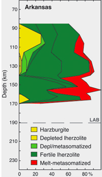
Figure 2. “Chemical Tomography” section showing the relative proportions of depleted and metasomatised rock types versus depth, as derived from Cr-pyrope xenocrysts. The relatively high proportion of fertile lherzolites is typical of the SCLM beneath many Proterozoic terranes. The figure is constructed by calculating the relative proportions of each garnet type at 50 °C intervals, using a sliding window 100 °C wide, to take account of probable uncertainties in the depth estimates.
These data suggest that the SCLM beneath the Prairie Creek area formed in Archean time, and has been progressively refertilised by a series of magmatic events, which appear to correlate in time with events in the overlying crust. The Archean SCLM sampled by the lamproites may represent the mantle root of the Sabine microcontinent, which is recognisable in the seismic tomography (Fig. 1) as the higher-Vs feature (100-175 km depth) that lies mainly to the south of the lamproite field. Seismic tomography also shows several blocks with high Vs beneath the Grenville province to the east, which may represent other microcontinental blocks. These findings suggest that the growth of individual continents is significantly affected by the accretion of older microcontinental blocks, and that the extent of old SCLM, and of early continental crust, therefore may be greater than generally estimated.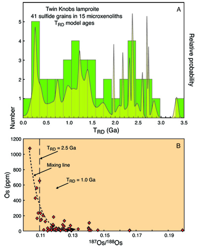
Contacts: Bill Griffin, Sue O’Reilly, Graham Begg
Funded by: ARC Discovery and Linkage Projects
Figure 3. Re-Os data for sulfide grains in xenoliths from the Twin Knobs lamproite. (A) Cumulative-probability plot and histogram for Re-depletion ages (TRD); (B) Plot of Os content vs 187Os/188Os; the negative correlation at low 187Os/188Os suggests reaction (mixing) between old high-Os sulfides and younger sulfide melts with low Os and high 187Os/188Os. Vertical dashed lines show 187Os/188Os corresponding to TRD = 2.5 Ga and 1.0 Ga.
Zircons reveal 3.5 billion-year old crust beneath central Spain
Our first results on zircons from the lower-crustal granulite xenoliths of the Variscan orogenic belt of central Spain provide evidence for the existence of Paleoproterozoic-Archean (up to 3.5 Ga) components in the deep crust, even though the exposed crust is much younger (GEMOC/CCFS Publication #721). This is supported by both widespread Paleoproterozoic-Archean Hf model ages and the presence of inherited zircon cores with comparable U–Pb ages. Around 75% of zircon grains show inherited cores defining age clusters in Archean (3371–3453 Ma), Proterozoic (618–1680 Ma) and Early Paleozoic (440–573 Ma) time (Fig. 1).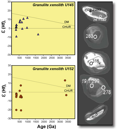
Figure 1. Initial εHf values of individual zircon grains from some of the studied granulite xenoliths.
Hf-isotope data are useful for estimating the timing of significant production and/or preservation of juvenile continental crust. Thus, the presence in an outcropping migmatite (the Cervatos anatexite) and in the granulite xenolith U152 of two old zircon cores showing markedly positive εHf values (+4.4 and +13.1, at 2180 and 3371 Ma, respectively; Fig. 1), suggests the possibility of juvenile addition during Palaeoproterozoic and Archean times. Figure 2 presents a summary of the Hf model-age data collected on the studied granulitic rocks as well as the range of whole-rock Nd model ages available for them. The resulting juvenile continental-growth histogram shows a continuum between 0.95 and 2.3 Ga, with a predominance of 1.0–1.8 Ga ages and a peak at 1.6–1.7 Ga. Nd and Hf model ages in the range of 1.4–1.7 Ga may represent mixing of Late Proterozoic juvenile components with variable proportions of older crust of Paleoproterozoic and possibly Archean age. The presence of very old crustal components in Neoproterozoic successions deserves a thorough debate in the future, when forthcoming data from metamorphic rocks of the Iberian Massif are available.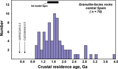
Figure 2. Histogram of Hf Model ages of zircons from the four studied granulite-facies rocks from central Spain. The range of whole-rock Nd model ages is shown for comparison.
Some of the recent paleogeographic reconstruction models suggest northern African sources for the Mesoproterozoic inheritances in the metasediments of the Central Iberian Zone. In this study age populations in the interval 800–1250 Ma are interpreted as evidence of the location of NW Iberia between the West African Craton and the Saharan and Arabian–Nubian shields (Fig. 3). The Hf-isotope data presented here record only a minor mantle input at 1.0–1.2 Ga in central Iberia, which is markedly younger than the more widespread crust-forming event at 1.3–1.6 Ga recorded in other continental blocks (e.g. Amazonia, Australia, Ukraine). On the other hand, crustal-generation events in central Africa at 1.0–1.3 Ma, reported recently for detrital zircons from central Africa (Congo Craton), match the distribution of Hf model ages of the granulite zircons from central Spain better than those from the Amazonian and West African cratons. This implies that during early Neoproterozoic and late Mesoproterozoic times, NW Iberia was far from the Amazonian Craton, and that its position to the north-east of the West African Craton might be a more reasonable option (Fig. 3). Furthermore, palaeogeographic reconstructions for Early Paleozoic time, based on benthic faunas, support the idea that NW Iberia was probably closer to the Algerian Sahara or Libya than to the Moroccan part of the North Gondwanan shelf.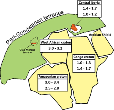
Contacts: Elena Belousova, Carlos Villaseca (Universidad Complutense de Madrid)
Funded by: ARC Discovery (O’Reilly, Griffin, Pearson), Industry
Figure 3. Hf-isotope data of granulite zircons agrees with recent palaeogeographical reconstruction models that show central Iberia as a Peri-Gondwanan terrane located between the West African craton and the Arabian shield, far from the Amazonia microplate. The main Hf-isotope TDM peaks in relative-probability histograms are shown for different cratons (Amazonia, West Africa, central Africa).
Zircons from South China Block, reveal hot (non-glacial) origin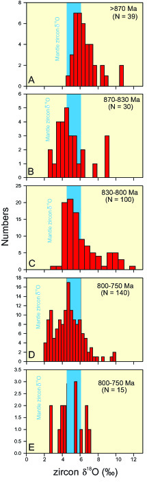
Low δ18O signatures in supracrustal rocks have been regarded as a signal of cold paleoclimates such as glaciations. Unusually low δ18O values in Neoproterozoic igneous rocks in parts of the South China Block have thus been genetically linked to Neoproterozoic glaciation events. However, the oxygen isotope compositions of Neoproterozoic magmatic zircons in central South China, measured using in situ techniques, argue against such an interpretation. Our results show that low-δ18O magmatic zircons started to appear in South China from ca 870 Ma, coinciding with the tectonic switching from the Sibao Orogeny to post-orogenic extension, which occurred >150 Ma prior to the first glaciation event. The most abundant low-δ18O magmatic zircons have ages of 800–700 Ma. 830–700 Ma magmatic zircons show a bimodal distribution of δ18O: mantle-like (+ 4.4 to +5.8‰) and high δ18O (+9.3 to +10.8 ‰). A sharp temporal change in maximum zircon δ18O values in South China coincided with the onset of continental rifting and the possible arrival of a plume head. No negative-δ18O zircons have been identified in this study, contrary to previous studies (Figs. 1 and 2). These features strongly argue against a glaciation origin for low to negative δ18O values in Neoproterozoic magmatic zircons from South China. We propose that two stages of high-temperature water-magma interaction during plume-driven magmatism and continental rifting best explain the low-δ18O magmas. The most important implication of this study is that formation of such low δ18O magmatic zircons was not necessarily related to glacial events and should not be used as a geochemical marker of a cold paleoclimate.
Figure 1. Oxygen isotope compositions of zircons with ages of (A) >870 Ma, (B) 870–830 Ma, (C) 830–800 Ma, (D) 800–750 Ma, and (E) 750–700 Ma. Number of bins in (D) is 25 and 15 for others (Modified after Wang et al., 2011, Geology, v. 39, no. 8, p. 735-738).
This study shows that the extremely negative δ18O values from the Dabie-Sulu UHP metamorphic rocks are most likely due to metamorphic processes. The main evidence for this is the presence of extremely low-δ18O metamorphic minerals including garnet (δ18O = +5.6‰ to -10‰), omphacite (δ18O = +7.0‰ to -9.4‰), and phengite (δ18O = 1.3‰ to -9.1‰) (Zheng et al., 1998, EPSL, v. 155, 113–129). Air-abraded zircons gave higher δ18O values (0.1‰–1.0‰) than those processed without air abrasion (Zheng et al., 2004). Recently, new oxygen-isotope and U-Pb age records of metamorphic zircon grains from UHP eclogites from the Dabie Sulu belt showed that δ18O values of 850-720 Ma igneous zircon cores are similar to our results and all the negative δ18O values are found in metamorphic rims on zircon grains (Chen et al., GCA, v.75, 4877-4898, 2011). We therefore propose a two-stage high-temperature alteration model to explain the extremely low δ18O values found in the Dabie-Sulu metamorphic rocks. The first stage represents pre-glaciation high-temperature hydrothermal alteration as discussed earlier. The second stage involves meteoric-hydrothermal alteration under ice age conditions at ≤720 Ma. The oxygen isotopes of pre-glaciation magmatic and sedimentary rocks preserved in the rift basins may have acquired negative δ18O values during the second stage, although their magmatic zircons would have retained their primary features. Such altered rocks served as the protoliths of UHP metamorphic rocks, thus generating metamorphic minerals and zircon rims with extremely negative δ18O values.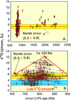
Contacts: Xuan-Ce Wang, Xian-Hua Li, Zheng-Xiang Li, Qiu-Li Li
Funded by: NSFC grant (CI: Professor Xian-Hua Li, commencing 2011, Partner Institution CAS)
Figure 2. Zircon δ18O values versus U-Pb ages for (A) all analysed grains and (B) 900–700 Ma grains. The thick arrow lines in (B) show the evolution of maximum oxygen isotopes (Wang et al., 2011, Geology, v. 39, no. 8, p. 735-738).
Yilgarn Seismic Reflection Survey released
The Youanmi deep seismic reflection survey, acquired across the Yilgarn Craton in May and June 2010, has been released on 22 February 2012 (http://www.dmp.wa.gov.au/13230.aspx). The deep seismic reflection data and the magnetotelluric data are part of a GSWA-led project within the Centre of Excellence for Core to Crust Fluid Systems, aimed at developing a 3D understanding of the lithospheric structure of the northwest Yilgarn Craton, its development through time, and the link to large-scale mineralisation.
The survey was funded through the Western Australian Government’s Royalties for Regions Exploration Incentive Scheme (EIS). Terrex Seismic Pty Ltd (http://www.terrexseismic.com/), an Australian company based in Perth, carried out the seismic data acquisition, and Geoscience Australia (GA) managed acquisition, processing and interpretation.
The survey builds on the existing network of deep-crustal seismic surveys that have imaged the Yilgarn Craton and its margins, and will improve the understanding of the crustal structure of Western Australia. Three individual seismic lines (YU1, YU2 and YU3), along with complementary magnetotelluric data, were acquired as part of the survey.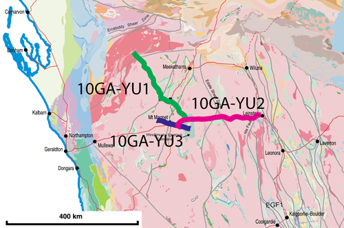
Figure 1. Location of the YU1, YU2 and YU3 seismic reflection lines in the Yilgarn Craton, Western Australia.
The three lines cross the northern part of the Yilgarn Craton from the Narryer Terrane in the northwest, across major bounding and internal structures of the Youanmi Terrane and into the Kalgoorlie Terrane of the Eastern Goldfields Superterrane (Fig. 1). The eastern end of YU2 (Fig. 2) crosses major structures on the western side of the Eastern Goldfields Superterrane, which were also imaged by the 2001 GA deep seismic reflection line (01AGS–NY1), about 120 km to the southeast.
The main objectives for the Youanmi deep seismic reflection survey are to:
- Image deep structure in the Narryer Terrane, the oldest component of the Yilgarn Craton, and the region that contains the oldest known crust in Australia;
- Image the contact between the Narryer Terrane and the adjacent, highly mineralised Murchison Domain of the Youanmi Terrane;
- Investigate the nature of granite–greenstone contacts and the overall shape, depth, and structure of greenstone belts;
- Compare the nature, orientation, and crustal penetration of mineralised and unmineralised structures;
- Develop a 3D image of the mafic–ultramafic Windimurra Igneous Complex;
- Image the Ida Fault, the boundary between the Youanmi Terrane and the Kalgoorlie Terrane in the Eastern Goldfields Superterrane, and compare the deep structure in the adjacent terranes;
- Link with previously acquired deep-crustal seismic traverses in the Eastern Goldfields Superterrane.
Interpretation of the seismic lines will be undertaken ahead of a public release workshop planned for October/November 2012.
Contacts: Stephen Wyche (stephen.wyche@dmp.wa.gov.au), Klaus Gessner (klaus.gessner@dmp.wa.gov.au).
Funded by: NCRIS AuScope, Geoscience Australia, GSWA, CCFS Foundation Project
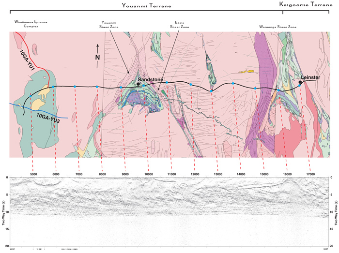
Figure 2. Geological map and preliminary migrated seismic reflection data of line YU2.
A new tectonic history for the Yilgarn predicts eastward expansion of gold prospects
The Albany–Fraser Orogen is an arcuate orogenic belt along the southern and southeastern margins of the Archean Yilgarn Craton in Western Australia. Previous studies ascribed the main tectonic and metamorphic features of the belt to the Mesoproterozoic Albany–Fraser Orogeny. However, a significant tectonomagmatic event is now known to have taken place during the Paleoproterozoic within the Biranup Zone of the orogen, and also suggests an allochthonous setting for much of the orogen. Magmatism in the Biranup Zone commenced at ca 1710 Ma, and the Hf-isotope signature indicates that the magmas were derived predominantly by melting of an Archean (Yilgarn craton) source (Fig. 1a). Younger intrusions, with crystallisation ages between 1680–1665 Ma, show a progressively higher proportion of juvenile mantle–derived material in their source. Lu–Hf and U–Pb data from individual zircons, as well as data from entire intrusive bodies, indicate more juvenile additions through time. This rapidly-evolving tectonomagmatic history, and the original Yilgarn-like Hf-isotope signature modified by juvenile material, suggests that an extensional setting, possibly a back-arc, on the margin of the Yilgarn Craton is a feasible tectonic setting for the Biranup Zone of the Albany–Fraser Orogen. Thus, the Hf- isotope data imply an autochthonous origin for much of the orogen. New Lu–Hf results indicate that the Fraser Zone represents addition of juvenile (mantle-derived) material into the crust of the Biranup Zone. This implies that basement to the Fraser Zone is Biranup Zone material, and the extent of rocks considered to be prospective for gold mineralisation probably increases eastward further than previously suspected.
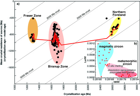 Figure 1. Lu–Hf data used to determine tectonic affiliations of Albany–Fraser Orogen rocks. (a) Event signature diagram showing the general trend with time produced by reworking (downwards), mixing (horizontal), or juvenile input (upwards). The vertical axis shows the “crustal residence time” (age) of the magma sources. The data are from three lithostratigraphic domains: the Biranup and Fraser Zones and the Northern Foreland. The Northern Foreland shows crustal-residence times consistent with an Eastern Goldfields Superterrane (Yilgarn Craton) heritage. The Biranup Zone displays a range of crustal residence times, from old signatures similar to the Eastern Goldfields Superterrane to values considerably less negative, suggesting juvenile addition to the crust. The Fraser Zone Hf is situated mainly between the 2.0 and 2.2 Ga crustal evolution lines and is compatible with the Fraser Zone having reworked Biranup Zone material. (b) Differences in Hf isotopes and Lu/Hf of magmatic zircon, and metamorphic zircon linked to garnet growth.
Lu–Hf isotopes also provide information on the growth mechanism of zircon (Fig. 1b), which is important for linking the growth of dateable minerals to the development of other minerals in the rocks. Metamorphic zircon rims produced during Stage II of the Albany–Fraser Orogeny consistently show more radiogenic Hf-isotope signatures, and lower Lu/Hf ratios, than those of igneous zircons. This relationship is best explained by breakdown of igneous zircon and the growth of garnet, depleting the metamorphic reservoir in heavy rare-earth elements (HREE). This metamorphic reservoir, with high 176Hf /177Hf but low Lu/Hf, was the source from which metamorphic zircon grew. This indicates that Stage II metamorphic zircon growth occurred under amphibolite-facies (or higher-grade) conditions.
Hf-isotope data from zircons in intrusive rocks of the western Musgrave Province indicate apparent crustal reworking following juvenile input events at ca 1900 and 1600–1550 Ma. Although no juvenile material is known from the older event, radiogenic addition into the crust is required to account for consistent Hf (and Nd) isotope evolution patterns, which show no indication of mixing processes. The timing of juvenile addition and the lack of similarity to Albany–Fraser and Arunta crust suggests that the ca 1900 Ma event reflects development of a mafic underplate on the margin of an Archean Craton. Oxygen isotopes in zircons with ca 1950–1900 Ma model ages indicate that their parent melts were not contaminated by near-surface material, so these model ages represent crustal generation. Correspondence in time between extraction of material from the mantle and the reworking of Archean material strongly supports a coupled response of the upper and lower crust to a juvenile crustal-generation event at ca 1900 Ma. The crustal evolution defined by Hf (and Nd) isotopes allows refinement of paleogeographic reconstructions and has implications for mineralisation styles.
Contact: Michael Wingate
Funded by: GSWA
Mapping Earth’s thermochemical structure in 3D
There are basically two sources of information we can use to constrain the compositional and temperature structure of Earth’s mantle: geophysical data (e.g. gravity anomalies, travel-time data, surface heat flow, etc.) and studies of mantle samples (e.g. xenoliths, tectonically-exposed massifs). Experimental petrology and numerical simulations can complement these observations, but they cannot really constrain the physical state of the mantle. Both geophysical data and mantle samples have advantages and limitations when used to infer the physical and chemical structure of the mantle. The geophysical data offer a larger and more continuous spatial coverage, but their conversion into estimates of composition and temperature is full of difficulties -- and they only reflect present-day conditions. The mantle samples, on the other hand, carry direct information on the compositional and thermal structure of the mantle when they were erupted or exhumed, but their spatial and temporal coverage is limited.
The most reliable way to map the thermochemical structure of the Earth’s interior would be via “multi-observable probabilistic inversions”, using many types of data and an internally consistent thermodynamic/geophysical formulation. However, the theory and implementation of such inversion schemes still are immature and greatly understudied. None of the current methods can handle the simultaneous, internally consistent inversion of 3D data for surface heat flow, gravity and geoid anomalies, electrical conductivity, absolute elevation, seismic velocities and composition. Moreover, available methods/software used to model the Earth’s interior cannot handle some major problems: i) the system is strongly non-linear, ii) the temperature effect on geophysical properties is much greater than the compositional effect, so the latter is hard to isolate, iii) the compositional data are non-unique (different compositions can fit seismic and potential-field data equally well), iv) strong correlations between physical parameters and geophysical observables complicate the inversion and their effects are poorly understood, and v) there are trade-offs between temperature and composition in seismic wave speeds.
We now have developed a new full-3D multi-observable inversion method particularly designed to circumvent these problems. Some key aspects of the method are: a) it combines multiple datasets (ambient noise tomography, receiver function analysis, body-wave tomography, magnetotelluric, geothermal, petrological, and gravity) in a single thermodynamic-geophysical framework, b) a general probabilistic (Bayesian) formulation is used to appraise the data, c) neither initial models nor well-defined a priori information are required, d) it provides realistic uncertainty estimates, e) it offers critical insights into the incompatibilities between traditional stand-alone methods, and f) it can incorporate geochemical/petrological information. The combination of different observables reduces the uncertainties because they are differently sensitive to shallow/deep, thermal/compositional anomalies. This allows a better control of the lateral and vertical variations of the bulk properties of the lithosphere and mantle.
The fundamental goal of this method is the conversion of observations into robust estimates of temperature and composition in the lithosphere and upper mantle. This requires the assessment of two different but related levels of functional relationships (or parameterisations). The first is between the raw observations and the set of governing physical parameters; e.g. the physical relationship between travel times and the subsurface seismic velocity structure or between variations in the surface electromagnetic field and the subsurface electrical conductivity structure. The second level of functional relationships is between the set of governing physical parameters (e.g. seismic velocity) and a more fundamental set of model parameters represented by the major-element composition and temperature of the rocks. Since this set of parameters (e.g. composition) controls the second set of governing physical parameters (e.g. shear velocity), they are commonly referred to as the primary and secondary parameters.
This first level is the simplest and most widely used in conventional inversion methods. Typically, we assume an appropriate physical theory (e.g. seismic wave propagation) and use that to relate the secondary model parameters to the observations during the inversion. The final result is one or more sets of secondary physical parameters (i.e. Earth models), such as shear velocity or electrical conductivity, that show an acceptable fit to the data. The second level of functional relationships is commonly ignored in inversion studies or treated as a posteriori independent (not self-consistent) corrections. Partly because of this, but also due to its intrinsic complexities (e.g. different compositions give the same seismic velocity), this functional level and its relationship with geophysical observables are less well-understood.
Figure 1 shows the comparison of a “real” input thermochemical model and the solution recovered after inverting surface and body waves, geoid and gravity anomalies, surface heat flow, and elevation. No magnetotelluric data have been included in this example. The input model and its observables were calculated with the software LitMod3D in a mesh of 50x50x204 nodes. The thermal structure is heterogeneous and contains added “noise” while the compositional structure is horizontally homogeneous, featuring three layers with distinct Mg#. Although the inversion mesh is much coarser (15x15x190), the two recovered structures are in excellent agreement with the original structure. This example shows that our probabilistic inversion scheme can distinguish between thermal and compositional signatures, something that other available methods cannot achieve.

Although the method still is being tested and benchmarked, our preliminary results are encouraging. They demonstrate that inversion of multiple geophysical and petrological data to obtain a thermochemical “tomography” of the upper mantle is possible and more reliable than other standard methods. This new approach opens the way to migrate from standard “parameter tomography” (e.g. seismic tomography) to future “multi-observable thermochemical tomography” schemes, the ultimate goal of geophysical methods.
Figure 1.
Contact: Juan Carlos Afonso
Participants: Juan Carlos Afonso, Javier Fullea, Yingjie Yang, Bill Griffin, Sue O’Reilly, Alan G. Jones, James A.D. Connolly, Sergei Lebedev and Nick Rawlinson
High strain below Tibet – mapping a mid-crustal low velocity zone
The Tibetan Plateau results from the convergence between the Indian and Eurasian plates, which has been going on since Late Cretaceous to Early Paleocene times. There is lively debate about the processes that have controlled the deformation of Tibet, particularly the potential localisation of deformation either in the vertical or horizontal directions. Two general models are commonly proposed. The first is the “rigid block” model in which deformation is primarily localised along active faults on the edges of the blocks. The second is the “internal deformation” model in which the crust is treated as a non-rigid continuum, like gummy candy, and deformation is spread across the blocks. In this model, strain disperses in the deeper crust into much broader ductile shear zones, in which the lithosphere may deform more or less homogeneously. This might be via “vertically coherent deformation” or by more rapid, ductile “channel flow” in the middle to lower crust.
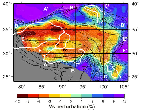 Figure 1. (a) Map of the amplitude of the crustal low-velocity zone across the region relative to 3.4 km/s. Yellows, oranges, and reds denote velocities at 30 km depth (relative to sea level) less than 3.4 km/s. White contours identify strong radial anisotropy found in the study of Shapiro et al. (2004). Note that the distribution of strong radial anisotropy is largely coincident with strong LVZs in western and central Tibet. Agreement is weaker in eastern Tibet, but this is probably due to the reduction of resolution in this region in the study of Shapiro et al (2004).
Geophysical data can help us discriminate between these competing models. In particular, it is important to determine whether Tibet deforms in a way that mimics the surface expression of crustal blocks and faults, and whether we can observe pervasive, interconnected weak layers or channels in the crust. There is a growing body of evidence that suggests the Tibetan crust is warm and thus presumably ductile. These observations are often taken as prima facie evidence for the existence of partial melts or aqueous fluids in the middle or deep crust beneath Tibet. Some have argued for the decoupling or partitioning of strain between the upper crust and uppermost mantle. This raises several questions. How pervasive are the phenomena that support the existence of crustal partial melt? In particular, do we see mid-crustal low velocity zones (LVZs) across Tibet? If we do, what is the geometry or inter-connectivity of the crustal LVZs across Tibet?
We addressed these questions by producing a new 3-D model of crustal and uppermost mantle shear wave speeds (illustrated by Fig.1 and 2). We used the Rayleigh wave dispersion observed on cross-correlations of long time series of ambient seismic noise, recorded from about 600 stations in the Chinese Provincial networks, FDSN, and PASSCAL experiments.
The 3-D model shows significant, apparently inter-connected, zones of low shear velocity across most of the Tibetan Plateau at mid-crustal depths (20-40 km). These low-velocity zones (LVZs) do not correspond to surface faults and, significantly, are most prominent near the periphery of Tibet. The observations support the internal-deformation model in which strain is dispersed in the deeper crust into broad ductile shear zones, rather than being localised near the edges of rigid blocks. The prominent LVZs coincide with strong mid-crustal radial anisotropy (Shapiro et al., 2004) in western and central Tibet. The anisotropy probably results at least partially from the alignment of anisotropic minerals by deformation, which mitigates the need to invoke partial melts to explain the observations. Irrespective of their cause (partial melts or mineral alignment), mid-crustal LVZs reflect deformation, and their amplification near the edges of the Tibetan plateau provides new information about the mode of deformation across Tibet.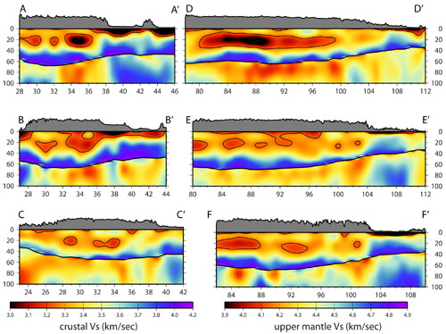
Figure 2. Vertical cross-sections of Vsv along the six profiles identified in Figure 1. Surface topography is shown at the top of each panel. Shear-wave speeds are presented in absolute units, but with different color scales in the crust and mantle. Very low shear-wave speeds in the crust (<3.25 km/s) are outlined by black contours. All depths are relative to sea level.
There are two specific seismic observations that are needed to extend and clarify inferences from the results presented here. First, higher-resolution Love wave phase velocity measurements obtained from ambient noise across all of Tibet are needed to infer Vsh in the middle crust. These observations will help to determine whether the observed LVZs result entirely or only partially from mineral alignment. Second, azimuthal anisotropy, observed both for the crust from ambient noise and for the uppermost mantle from earthquake records, will constrain the vertical continuity of the strain and will help to discriminate between channel flow and vertically coherent deformation. Both types of observations will be obtained in planned future studies.
Contact: Yingjie Yang
Funded by: MQ New Staff Grant
Komatiites deliver volatiles to early Earth’s surface
Komatiites are ancient volcanic rocks, mostly over 2.7 billion years old, which formed through high-degree partial melting of the mantle. Establishing the volatile content of komatiites is crucial to constraining the thermal evolution of the Early Earth and its primordial atmosphere. However, existing models are mainly based on evidence from komatiite flows, whereas komatiite intrusions have been neglected.
Our observations on komatiites from the Agnew-Wiluna greenstone belt of Western Australia show that komatiite flows must have degassed during emplacement, flow and crystallisation: flows ~150 metres thick contain vesicles, amygdales and segregation structures, showing a significant volatile content, but those less than 10 metres thick lack any textural or petrographic evidence of primary volatile contents. This implies that komatiite intrusions retained higher proportions of their primary volatile budget, and contain volatile-bearing mineral phases that reflect the presence of magmatic water in the parental magma. This means that evidence from komatiite intrusions, rather than lava flows alone, should be used to evaluate the thermal architecture of the Early Earth and the volatile inventory of the primordial atmosphere.
The results of this study indicate the possibility of a range of volatile contents in different komatiite types. In fact, our observations suggest that some komatiites were initially volatile-bearing and subsequently lost their volatiles. This would be facilitated by the low viscosity of komatiite magmas, allowing volatiles to bubble out more easily, and (or) by emplacement in shallow marine environments (i.e. low confining pressures). The diversity in the physical evidence for magmatic volatile contents may reflect different proportions of degassing caused by variable confining pressure and proximity to vent. Komatiite flows that lack hydrous magmatic minerals and textural or petrographic evidence of primary volatile interaction may be the degassed equivalents of volatile-bearing liquids. Alternatively, they could represent melts that were actually anhydrous. If so, the variable physical evidence for volatile content in komatiite units globally may reflect the presence of “wet” and “dry” komatiites, which were most likely emplaced in different geodynamic environments, just as a diversity of basalt types exist in more recent terrains.
The principal significance of the presence of magmatic amphiboles in some komatiitic and ferropicritic sills in the Agnew-Wiluna (Australia), Abitibi (Canada) and Pechenga (Russia) greenstone belts is that they reflect the crystallisation of hydrous parental magmas. The diverse nature of the physical evidence for magmatic volatiles in komatiite units that solidified at different distances from vent highlights means that we need to focus on evidence from proximal intrusions or thick flows, which may have retained a significant proportion of their primary volatile budget. Previous studies have mainly focused on thin lava flows without considering the effects of degassing, whereas thicker flows or intrusions have been generally neglected.
A re-assessment of the primary volatile content of komatiite magmas from intrusive settings has key implications for the thermal and petrological evolution of the Early Earth, localisation of nickel-sulfide ores, and development of the primordial atmosphere. The extreme Archean geothermal gradients advocated to explain the formation of komatiites in dry settings may have not been necessary to extract komatiites from volatile-bearing portions of the mantle. The localisation of “dry” and “wet” komatiites may reflect the presence of different Archean geodynamic environments (e.g. rift settings versus subduction zones). Correlation of H2O contents and physical evidence of volatile content with proximity to Archean volcanic centres and intrusions could be significant in petrologic models and in mineral exploration. A relatively high water content, reflected by presence of magmatic amphibole, may reflect proximity to vents. Therefore, if komatiite-hosted nickel-sulfides form preferentially in proximal extrusive and dynamic intrusive environments, careful mapping of the physical evidence for volatile contents in different volcanic facies may help to identify areas with greater potential for nickel-sulfide deposits.
Finally, degassing of komatiites would have also contributed to the development of an early atmosphere, through volatile exchange at the ocean surface. Since komatiite flow fields were extremely voluminous and occupied extensive areas of the seafloor, volatile exsolution during their emplacement and crystallisation could have influenced physical and chemical parameters in the primordial oceans, and indirectly contributed to the creation of a complex zonation at the interface between water and seafloor.
Contacts: Marco Fiorentini, Steve Beresford
Funded by: ARC Discovery
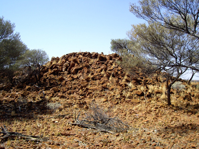
An Australian komatiite outcrop.
Water deep in the mantle-A key to transforming the Lithosphere?
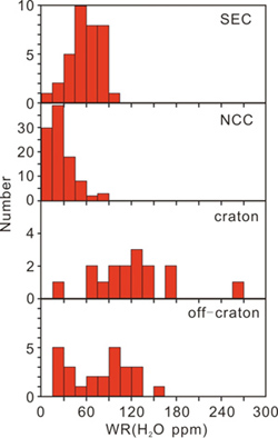 Figure 1. Comparison of H2O contents whole-rock (WR) of the Cathaysia (SE China) xenoliths in this study with those of North China Craton (NCC), craton and off-craton peridotites. For the references of data for NCC, cratonic and off-cratonic peridotites see CCFS Publication #2.
Besides the visible H2O on the Earth’s surface, there is another unexpected and invisible H2O reservoir at depth. This is the H2O in the mantle, ‘dissolved’ as hydroxyl in the crystal structure of major mantle minerals. It relates not only to the probability of life, but also to geological processes.
Refractory subcontinental lithospheric mantle (SCLM) is produced by the removal of partial melts from mantle rocks; this process includes the removal of this deep H2O. The nature and evolution of the SCLM are strongly influenced by hydrous melts and fluids, which affect the physical and chemical properties of mantle minerals and rocks. Like some light rare earth elements (LREEs) (La, Ce) or large ion lithophile elements (LILs) (K), H2O behaves as an extremely incompatible component (Dperidotite/melt = <0.01) in a melt/solid system, which makes it a sensitive tracer of melt-extraction and metasomatism in the SCLM. Thus an understanding of the H2O inventory of the SCLM provides another tool to study the nature and the evolution of the SCLM, and the role H2O has played during lithospheric modification.
Peridotite xenoliths in alkali basalts consist mainly of nominally-anhydrous minerals (e.g. olivine, pyroxene) and these can be analysed to measure the actual H2O budget of the SCLM. This study has focused on determining the H2O contents of peridotite xenoliths from four localities (Mingxi, Anyuan, Niutoushan and Qilin) in the Cathaysia block of SE China, using Fourier Transform Infrared Spectroscopy (FTIR). We studied (1) the homogeneity of water distribution within single pyroxene grains; (2) the partitioning of water between cpx and opx (mean Dcpx/opx = 2.3); and (3) the correlations between the H2O contents and major element concentrations in cpx. From these data it appears that the pyroxenes have largely preserved the water content of their mantle sources.
The whole-rock water contents calculated from mineral modes range from 12 to 94 ppm (average 60±20 ppm). This is much higher than the previously-reported water contents of xenoliths from the North China Craton (NCC) (average 26±17 ppm). However, it is still quite low compared to those of continental lithospheric mantle worldwide, as inferred from analyses of typical cratonic (122±54 ppm) and off-craton (81±40 ppm) peridotites (Fig. 1). The present relatively low water budget has evolved through multiple geological events over the long history of this SCLM, e.g. hydration due to paleo-Pacific plate subduction, dehydration by melt extraction during Yanshanian magmatism (Fig. 2a) and subsequent rehydration due to the fluxing by low-degree asthenospheric melts after lithospheric thinning (CCFS Publication #2) (Fig. 2b). This is evidenced by young basaltic volcanism at the surface. Water itself plays an important role during the modification of the subcontinental lithospheric mantle. The garnet lherzolites, which represent the deepest portion of the SCLM (~1.9 GPa) sampled in this study, have the highest water contents (>80 ppm). This fertile garnet-facies layer, at depths of 50-100 km, appears to have lost very little water. It may represent young lithosphere accreted at the bottom of the pre-existing lithosphere (Fig. 2b). It marks the completion of the lithospheric thinning episode and the upwelling of the asthenosphere.
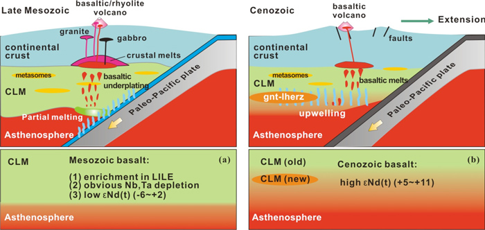
Figure 2. Cartoon showing (a) hydration due to water released from the subducted slab, and dehydration after melt extraction in Yanshanian magmatism. The enriched signatures in the Late Mesozoic basalts reflect contributions from the hydrated SCLM; (b) rehydration by low-degree asthenospheric melts after lithospheric thinning. The upwelling and decompressional melting of asthenosphere is supported by decreasing contribution from SCLM in basalts in SE China over time, with εNd (t) of −6~+2, and +5~+11 for Late Mesozoic and Cenozoic, respectively.
A negative correlation between pyroxene water contents and oxygen fugacity has been found only in xenoliths from Niutoushan (Mg# < 90), which lies on the Changle–Nan’ao fault zone. The fault may have facilitated the infiltration of the Niutoushan peridotites by oxidised fluids (or hydrous melts) rising from the subducting Pacific plate.
Contacts: Yao Yu, Bill Griffin, Sue O’Reilly
Funded by: NSFC Grant 40730313, ARC Discovery and Linkage grants (O’Reilly and Griffin), iMQRES, EPS Postgraduate Fund
Metasomatic highways - 200 km below Earth’s surface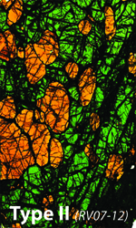
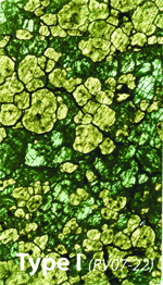
Figure 1. Examples of microstructures in Type I and Type II eclogite xenoliths from Roberts Victor.
Mantle eclogites are amazing and enigmatic messengers coming directly from the base of the cratonic lithosphere (180-220 km down). Although the processes that originally produced these rocks are yet to be fully understood, they are critical samples to constrain the dynamics of the sub-continental lithospheric mantle (SCLM). Because of their privileged position at the lithosphere-asthenosphere boundary (LAB), they are witnesses of the interactions between the lithospheric mantle and the asthenosphere.
Eclogite xenoliths recovered from the Roberts Victor kimberlite pipe (Kaapvaal Craton; South Africa) reveal peculiar features that indicate that the rocks have been modified since their emplacement. Recent studies done at CCFS/GEMOC (CCFS/GEMOC Publication #003/772) have shown that most of the Roberts Victor eclogites (Type I eclogites) underwent intensive metasomatism, provoked by substantial melt/fluid percolation not long before the kimberlite eruption (Fig. 1). Although this process was inferred from entirely metasomatised xenoliths, the transformation has also been recorded in some composite xenoliths that contain both original and metasomatised lithologies.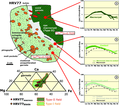
Figure 2. Sketch of the petrographic structure of composite xenolith HRV77 and the associated chemical variability. Cpx boundaries are not represented in the bimineralic part but grain-size is similar to garnet. Contact is composed of the macrocrystic cpx showing features of destabilisation. Bottom quadrilateral shows variations of major-element compositions between dusty garnets sitting in the bimineralic part (diamonds) and ovoid clear garnets sitting in the cpx macrocryst (circles). Right side REE patterns of cpx: (1) macrocrystic cpx; (2) macrocrystic cpx close to contact and contact itself; (3) cpx in the bimineralic part. Note the progressive enrichment in LREE from a Type II pattern to the typical Type I pattern.
HRV77 is a remarkable example (Fig. 2), which highlights how metasomatic fluids have percolated through the eclogite body via metasomatic channels. This sample is composed of two parts. One is a clinopyroxene macrocryst associated with a few clear, ovoid garnet grains. The surrounding part is mostly bimineralic (grt+cpx) but also contains sulfide, phlogopite and calcite. In this part the garnets are cloudy, show irregular shapes (irregularity increasing with distance from the contact) and contain blebs similar to melt pockets. From these petrographic observations, we conclude that the bimineralic part represents a metasomatic channel, in which cpx and grt recrystallised and metasomatic minerals have been added. Supporting these observations, major- and trace-elements also show clear differences between the two parts. While the cpx macrocryst shows a LREE-depleted pattern similar to the un-metasomatised Type II eclogites, cpx from the bimineralic part shows enrichment in LREE, as observed in the dominant Type I metasomatised eclogites. In situ Sr-isotope analyses of the clinopyroxene also support such a dichotomy. The cpx macrocryst has 87Sr/86Sr = 0.7029 (cpx from Type II eclogites have 87Sr/86Sr = 0.7013 – 0.7030) while the bimineralic part with 87Sr/86Sr = 0.7068 is typical of Type I eclogites (87Sr/86Sr = 0.7060 – 0.7064).
These obvious contrasts of chemistry and microstructure in such an intimate relationship imply that the bimineralic part witnessed the transit of a melt/fluid with which it interacted, while the macrocrystic part represents the wall-rock of this percolation vein (Fig. 3). 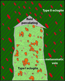
This kind of sample is of the greatest interest because they are the “missing link” between the two main types of eclogites recovered at Roberts Victor. They offer a spatial connection between the two types, indicating that their relationship is of a “mother-daughter” nature; they are not simply cousins as has been previously inferred in the literature.
Contacts: Yoann Gréau, Jin-Xiang Huang, Bill Griffin, Sue O’Reilly
Funded by: ARC Discovery (O’Reilly, Griffin), iMURS, EPS postgraduate Fund
Figure 3. Cartoon showing the possible fluid percolation mechanism and the formation of (metasomatised) Type I eclogites at the expense of Type II.
Diamonds highlight mantle fluid processes
Diamonds are “time capsules” that can preserve the geochemical signatures of their formation environment and trap inclusions from their matrix, providing unique insights into the mantle environment. They are carried from the mantle to the surface by very deep-seated, violent volcanic eruptions, from depths greater than 150 km. It is very likely that COH fluids percolating through the deep mantle caused the eruptions and also were the source of carbon for diamond formation. Interaction of oxygen and carbon in mantle processes defines and controls diamond formation (for example, precipitation and dissolution of diamonds, transportation of incompatible elements).
This project aims to combine the information that can be extracted from diamonds and other minerals, formed in the mantle. Studying the internal structure, physical and chemical properties of diamonds and related minerals, we are trying to uncover the mystery of the carbon source, which still is a controversial subject. Using the diamond and coexisting minerals we can provide a better understanding of diamond formation processes, which are related to major mantle processes and mantle composition, and can help us to understand the geological evolution of our planet.
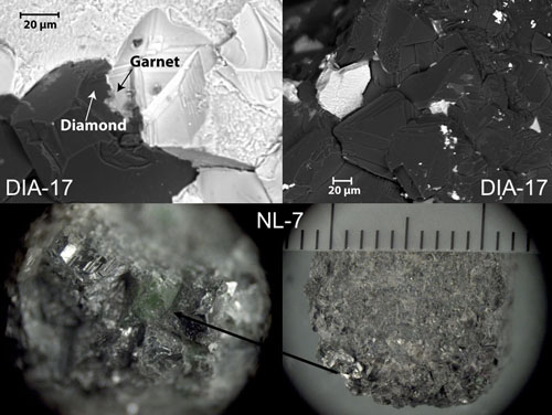
Figure 1.
We use diamondiferous mantle xenoliths from African and Siberian kimberlites as a source of information about mantle processes. This work, combined with the PhD studies of Yoann Gréau and Jin-Xiang Huang (see Research Highlight) has shown that mantle metasomatism (chemical alteration by fluids) plays an important role in diamond formation and is responsible for changes in geochemistry of silicates. In 2011 a new approach was taken, looking at the genesis and evolution of polycrystalline diamond aggregates (diamondites; Fig 1). Using the Electron Backscattered Diffraction (EBSD) technique, we made the first observations and interpretations of diamondite microstructures. The technique produces maps of the crystallographic orientation of the different diamond crystals in the aggregate, and also maps the distribution of silicate minerals that occur as inclusions and interstitial grains (Fig. 2). The study demonstrated that most diamondites have been significantly modified by deformation and recrystallisation processes. Many originally crystallised as relatively coarse-grained diamonds with abundant silicate inclusions; as they recrystallised under stress the grain sizes were reduced and the silicate phases moved to grain boundaries. Using integrated datasets including microstructural observations and in situ analyses of trace elements, C-isotopes in diamond and O-isotopes in the silicates, we found that many diamondites have an extended mantle-residence history including deformation/crystallisation processes and fluid interaction after initial crystallisation. The fluids changed the crystallisation environment (chemical composition of silicates) and may have provided carbon for secondary diamond formation. Based on the differences in chemical composition of the enclosed and interstitial silicates and zoning in the carbon isotopic composition of diamonds we can conclude that the host fluids were Mg-rich. An important conclusion was that polycrystalline diamond aggregates should not be interpreted as the products of primary crystallisation shortly before eruption, and detailed observations of their internal structures must play an important role in the interpretation of their genesis.
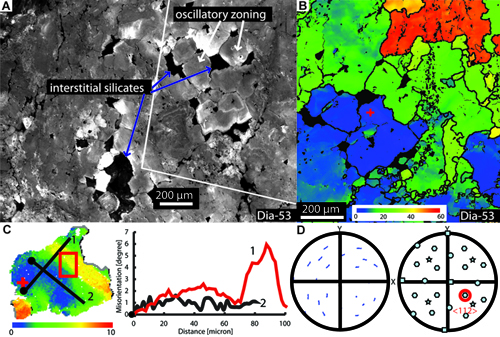 This study offers us new insights into mantle processes including diamond formation, deformation and fluid/melt interaction, and illustrates the complexity of the mantle system and the important role of fluids in it. The understanding of the fluids’ compositions and interactions in the mantle is probably a clue to the variation in the geochemistry of the mantle system itself.
Contacts: Ekaterina Rubanova, Dan Howell, Bill Griffin, Sue O’Reilly, Norman Pearson
Funded by: ARC Discovery, CCFS Foundation Project, iMURS, EPS postgraduate fund
Figure 2. Photomicrograph (A) of a polished diamondite. (B) EBSD image of the field outlined in (A). Different colours show different crystallographic orientations. (C) Traverses across a weakly deformed diamond grain. (D) Orientations of diamonds in (B).
Unveiling fluid histories in deep mantle eclogites with sulfide 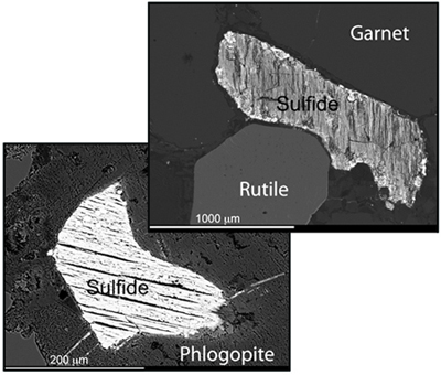 compositions
Figure 1. Eclogitic sulfides associated with metasomatic minerals, rutile and phlogopite.
Eclogite xenoliths are commonly found in kimberlites that erupted in cratonic areas. These rocks, sampled by the ascending magma, are minor but important constituents of the sub-continental lithospheric mantle (SCLM). However a long-lived debate still rages about why such mafic lithologies occur in the SCLM. The currently dominant line of argument sees mantle eclogites as remnants of subducted oceanic slabs stored in the cratonic SCLM, while other researchers regard mantle eclogites as deep-seated mafic melts trapped near the lithosphere-asthenosphere boundary (LAB). A recent study (CCFS Publication #003) pointed out that the “subuction” hypothesis was mostly based on the study of the more common Type I eclogites (defined by higher levels of the minor elements Na and K in garnet and clinopyroxene, respectively). These eclogites were shown to possibly not be the best choice as their microstructures and lithophile-element geochemistry indicate that they have been intensively over-printed by at least one metasomatic event. The less common Type II eclogites may represent primary, or at least less-altered, compositions.
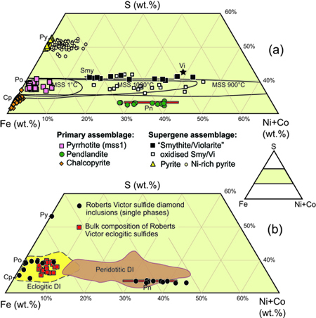 Figure 2. Electron-probe analyses of individual phases plotted on Fe-Ni-S diagrams.
Type I eclogite xenoliths recovered from Roberts Victor kimberlite (Kaapvaal Craton; South Africa) contain abundant polyphase sulfides (up to several modal %). Although many of these sulfides have undergone supergene weathering (i.e. transformation to violarite, smythite and pyrite), some samples present fresh unaltered assemblages made of pyrrhotite (Po) + pentlandite (Pn) + chalcopyrite (Cp). This typical magmatic assemblage is similar to sulfide inclusions found in Roberts Victor eclogitic diamonds, and more generally the reconstructed bulk sulfides are similar to sulfide inclusions in eclogitic diamonds worldwide (Fig. 1).
In Roberts Victor eclogites, although sulfides are systematically lacking in Type II eclogites, they are ubiquitous in Type I, and are often found in close association with metasomatic minerals like phlogopite and rutile (Fig. 2). It is therefore perhaps not accidental that both diamonds and sulfides are only found in Type I eclogites. A growing body of evidence indicates that diamonds are metasomatic minerals, but is this the case for the eclogitic sulfides? Chalcophile elements (elements with affinities for sulfur) such as Cu or Se might be the clue; they will be mostly carried by sulfides, and they can therefore be used as proxies to trace their origin. 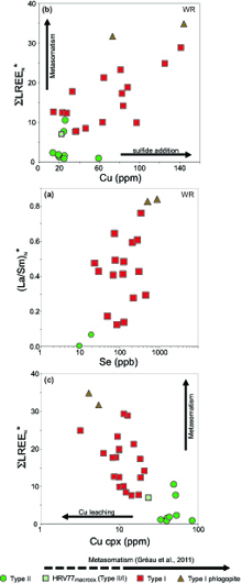
Correlations between the whole-rock budgets of these elements and typical metasomatic tracers such as (La/Sm) or ΣLREE (Fig. 3) clearly indicate that the sulfides are related to the metasomatism affecting the silicate assemblage. Furthermore, a negative correlation between the Cu content of clinopyroxene and ΣLREE shows how Cu is leached from the silicates during the crystallisation of sulfide associated with the metasomatic event. These data provide another line of evidence to confirm that Type I eclogites have been heavily over-printed by metasomatism, meaning that Type II are the only suitable rocks to constrain the origins of mantle eclogites.
Contacts: Yoann Gréau, Bill Griffin, Sue O’Reilly, Olivier Alard (Montpellier)
Funded by: ARC Discovery (O’Reilly, Griffin), iMURS, EPS postgraduate Fund
Figure 3. Correlations between metasomatic tracers and sulfide addition.
The Hainan Plume samples an ancient mantle reservoir
Subduction of oceanic slabs to the core-mantle boundary (CMB) as part of plate tectonic processes, and hot mantle plumes that rise from the lower mantle, are two of the major phenomena that have operated through much of Earth’s history. However, it is unclear how they interact with each other and whether they are parts of a single geodynamic system; this is a gap in our understanding of how the Earth works. Southeast Asia is a unique site to test possible genetic linkages between deep subduction and plume generation because both phenomena have been seismically detected in the deep Earth in this region.
Figure 1. Comparison of fractionation-corrected Hainan basalts (compositions in equilibrium with Fo90.7, corrected for olivine addition), with experimental partial melts. Also shown for reference are the primary-melt estimates of HIMU, EM1, and EM2 mantle end members (CCFS Publication #24).
Recent geophysical studies made a surprising discovery: a plume-like low-velocity structure, called the Hainan plume, beneath Hainan Island and the Leizhou peninsula (Leiqiong) in Southeast Asia. This low-velocity structure goes down 1300–1900 km and may emanate from the lowermost mantle, making it one of perhaps a dozen postulated lower-mantle plumes worldwide. Global occurrences of mantle plumes and subducting slabs since the Mesozoic generally are found in different areas, with plumes in the broad Pacific and African mantle upwelling zones (commonly called superplumes) and subduction in mantle downwelling zones. However, seismic tomographic studies show that the plume-like Hainan low-velocity structure sits close to the subduction zones of the Pacific, Philippine Sea and South China Sea slabs to the east, and the Indo-Australian slab to the south and west, and is far from both superplumes. This suggests that the Hainan plume is unique in being linked to the subduction of tectonic plates; if so, it sheds new light on the workings of the global geodynamic system.
The primary melts for the Hainan basalts have been estimated using the most forsteritic olivine (Fo90.7) as the final olivine and less evolved bulk samples (MgO >9.0 wt% and CaO >8.0 wt%), assuming a constant Fe-Mg exchange partition coefficient of KD = 0.31 and Fe3+/FeT = 0.1. The calculated primary melt compositions are similar to those of fractionation-corrected EM-1 and EM-2 type OIBs (Fig. 1) and plot within the overlapping experimental fields defined by partial melting of silica-deficient eclogites and peridotite (Fig. 1). According to the primary melt compositions, the effective melting pressures (Pf) and melting temperatures (T) form an array that plots systematically above the dry lherzolite solidus but below the base of the lithosphere (Fig. 2). The Pf-T array (Pf = 0.0105 × e0.0052T, R2 = 0.81) begins at about 18 kbar (about 60 km) and intersects the dry peridotite solidus at about 50 kbar (ca 160 km). This intersection translates into a mantle potential temperature beneath Hainan Island of about 1500–1600 °C, which is approximately 200 °C hotter than ambient mantle but typical of thermal mantle plumes such as the Hawaiian plume (Fig. 2). Pb-isotope analyses suggest that the Leiqiong flood basalts were derived mainly from an ancient (4.5–4.4 Gyr) primitive-mantle reservoir preserved near the core-mantle boundary (CMB). Their Nd- and Os-isotope compositions also suggest a lower-mantle origin. The lower-mantle isotopic compositions and high mantle potential T, together with the lower mantle-rooted plume-like seismic velocity structure, all point to the existence of a deep Hainan mantle plume. The Hainan plume thus provides a rare example of a young lower mantle plume close to deep slab subduction.
 Contacts: Xuan-Ce Wang, Zheng-Xiang Li, Xian-Hua Li
Funded by: NSFC grant and ARC CCFS, ECSTAR and Foundation grants
Figure 2. Temperatures and pressures calculated for the Hainan basalts. Curved lines represent melting adiabats where F(%) represents fraction of melting. Near-vertical lines represent solid mantle adiabats. The lithosphere-asthenosphere boundary (LAB) beneath Hainan Island is at about 55 km depth as constrained by geophysical data (CCFS Publication #24). Garnet-in and spinel-out reactions occur at about 60 and 80 km for a steady-state geotherm.
Nickel in natural diamonds
Diamonds, along with the mineral and fluid inclusions they can contain, represent the deepest direct samples from the Earth’s mantle. Studying these diamond “capsules” as well as their contents has shed a lot of light on the chemistry of mantle fluids. An important tool for studying the chemistry of the fluids from which the diamonds grew is laser ablation mass spectrometry (LA-ICPMS), a technique pioneered at GEMOC for measuring trace elements in diamonds. This has been shown to be of most use for fibrous diamonds that contain abundant fluid micro-inclusions. Due to the low concentrations of trace elements in gem quality diamonds, a key requirement has been to trap a lot more material to analyse than is produced during a typical laser-ablation analysis.
To do this, we have had to develop a different way of ablating diamonds. Instead of passing the ablated material (suspended in gas) directly into the mass spectrometer, we pass it through a liquid. The gas bubbles off through the liquid and the ablated material is left behind in solution, where it can be analysed by ICP-MS. This allows us to ablate for several hours instead of minutes, capturing far more material than traditionally possible. Typical ablation pits made using this method measure 500 x 500 x 120 microns, compared with the 50-micron-diameter pits of most LAM-ICPMS analysis. While this method sacrifices the spatial resolution of regular LAM-ICPMS analysis, it achieves very low levels of detection for many trace elements.
Mixed-habit diamonds are those that show periods of smooth faceted octahedral growth and rough, hummocky cuboid growth, occurring at the same time. This often results in a center-cross feature, which may or may not be visible to the naked eye. These types of diamonds have been known to contain nickel, only in the cuboid sectors. This impurity is responsible for the green luminescence that is characteristic of these types of diamonds, but was something long thought to only occur in synthetic diamonds. While no measure of nickel concentrations in these diamonds has been made before, levels were estimated to be in the order of <0.1 ppm. 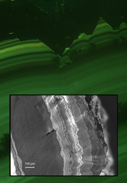 Preliminary LA-ICPMS analysis performed here at GEMOC has revealed concentrations ranging between 2 and 20 ppm. These samples were the motivation to measure even smaller concentrations of trace elements, to see if any other elements were preferentially partitioned into the cuboid sectors rather than the octahedral ones. It is already know that nitrogen is preferentially taken up into the octahedral sectors and important question marks remain regarding variations of hydrogen.
For nickel to be found in diamond suggests an absence of any sulfide phases during the time of growth. This is because nickel is a chalcophile element – one that would rather react with sulfur than with oxygen (i.e. to form silicates). Sulfides are one of the most common types of inclusions found in diamonds, so their absence may be indicative of the physical and chemical growth conditions that resulted in this special type of diamond growth. Further analysis of the impurities in these types of diamonds should help reveal more information about the role of fluids in the mantle.
Contacts: Dan Howell, Bill Griffin, Sue O’Reilly, Norman Pearson
Funded by: ARC Discovery (relinquished), CCFS Foundation Project
Chromites from dirt - a new pathfinder for nickel deposits
Figure 1. Black chromite grains in a heavy mineral concentrate. (photo: Elena Belousova).
The ever-increasing demand for global metal resources is creating many challenges for the metal exploration industry. Mineral deposits are not renewable and it is likely that all easily accessible giant deposits close to the surface have already been found. As a consequence, exploration for new ‘hidden’ deposits has to be extended to remote areas and deeper into the Earth itself, which is like looking for a needle in a haystack.
One way to aid exploration in a fast and cost-effective way is the analysis of resistate mineral phases from heavy mineral concentrates (Fig. 1). When water and wind erode rocks, mineral grains are liberated and may be deposited in nearby rivers. Minerals that are heavier and more resistant to destructive erosion than others are often trapped and concentrated in low-velocity parts of river beds and these “heavy mineral concentrates” provide an easily recovered sample of the entire catchment area of a drainage system. The minerals are analysed for their major- and trace-element compositions to identify element signatures that might indicate the nearby presence of a mineral deposit. This approach is used, for example, in diamond exploration, where garnet, chrome diopside and chromite are used as resistate indicator minerals to determine if a terrane is prospective for diamonds.
Figure 2a. Australian komatiite outcrops like this one are rare....
Figure 2b. …therefore geochemical exploration is often restricted to diamond drill cores.
In 2011, GEMOC investigated the potential use of heavy mineral concentrates in the exploration for komatiite-hosted nickel-sulfide deposits. Komatiites contain some of the world’s highest-grade nickel-sulfide deposits and the Archean Yilgarn Craton in Western Australia hosts several of these. The development of reliable prospectivity indicators to target exploration towards mineralised komatiite units has been a long-standing goal, particularly in Australia where komatiites rarely outcrop at the surface and geochemical exploration is often restricted to drill cores (Fig. 2a, b). Accordingly, the identification of an effective resistate indicator mineral for nickel-sulfide deposits that can be sampled at the surface could provide a major breakthrough in the exploration for mineralised komatiites.
Earlier research at GEMOC has shown that the ruthenium content of chromite can be used to discriminate mineralised from barren komatiites in pristine rocks from deep drill cores. Chromites from mineralised komatiites have distinctly lower ruthenium contents than chromites from unmineralised environments (see GEMOC annual report 2010). The research was extended in 2011 to see if the ruthenium content of chromites from heavy mineral concentrates can also be used in the exploration for nickel-sulfide deposits. As well as metamorphism and alteration, detrital chromites have inevitably undergone strong weathering, and primary ruthenium signatures may be obliterated by chemical modification of the chromite. To investigate how postmagmatic processes affect the ruthenium content of chromite, GEMOC’s state-of-the-art laser ablation ICP-MS facility (Fig. 3) has been used to analyse more than 500 chromite grains from komatiites, komatiitic basalts and ferro-picrites from the Yilgarn Craton of Western Australia, the Superior Craton of Canada and the Fennoscandian Shield of Finland and Russia. The sample suite included rocks that have undergone different degrees of metasomatism and alteration, and sampling depths ranged from several hundred metres below the surface to near-surface rocks that have undergone extensive weathering.
The results show that ruthenium is essentially immobile during postmagmatic processes and that chromite cores (as opposed to their rims) are relatively resistant to destructive metamorphism and alteration, as well as lateritic weathering. Therefore, primary magmatic ruthenium signatures can be preserved in chromites. Based on currently available evidence, high-ruthenium chromites are largely, if not entirely, restricted to unmineralised komatiites. Hence the presence of mixtures of high- and low-ruthenium chromite, of appropriate major element chemistry, in detrital heavy mineral concentrates is a reliable signal of mineralised komatiite sequences, and varying proportions of high- and low-Ru grains may be an indicator of proximity.
Figure 3. GEMOC’s state-of-the-art laser ablation ICP-MS facility.
As chromite is a widespread component of resistate heavy mineral suites, and large sample collections exist from previous diamond exploration programs, a prime opportunity has been created to investigate these sample collections, using an analytical technique that was unavailable when much of that material was originally investigated. Therefore, this technique could be an effective way to detect komatiite-hosted nickel-sulfide deposits, and could be used together with other geological, structural, geophysical and volcanological exploration techniques.
Contacts: Marek Locmelis, Norman Pearson, Marco Fiorentini
Funded by: CCFS Foundation Project
Copper can concentrate by collision
Porphyry copper deposits are in great demand with today’s exploration industries, supplying nearly 70 percent of the world’s copper, 50 percent of its molybdenum and 25 percent of its gold. Most of these deposits are formed above subduction zones, where one oceanic plate sinks beneath another continental or oceanic plate, such as in the Eastern Pacific. Traditionally, porphyry Cu deposits were found in subduction area such as in Chile and Peru. However in the last decade it has been discovered that porphyry copper deposits also can be found in continental collisional zones, where two continents collided after oceanic subduction terminated. However, our understanding of the processes of their creation remain limited. 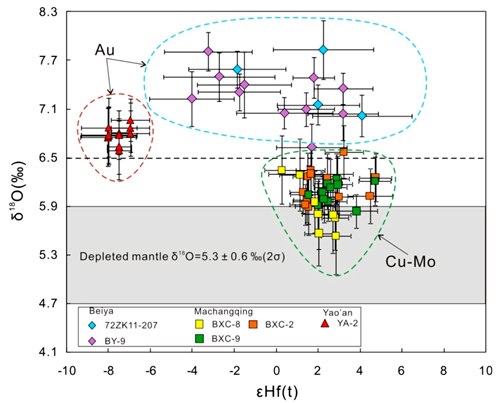
Figure 1. In situ zircon Hf-O isotope data for the Yao, Machangqing and Beiya intrusions.
Such deposits have been discovered mainly in the Alpine-Himalayan orogenic belt. Examples include the Eocene-Oligocene Yulong porphyry Cu-Mo belt of East Tibet, the mid-Miocene Gangdese porphyry Cu belt in southern Tibet, and the Neogene porphyry Cu-Au deposits of the southwest Pacific. Their formation involves distinct but as-yet poorly-understood processes unrelated to active subduction, ranging from deep generation of magmas and metal sources to exsolution and evolution of ore-forming fluids in the upper crust.
This CET study has examined porphyry copper systems in Western Yunnan, south-eastern Tibetan Plateau and resulted in new insights into the formation of porphyry Cu systems in continental collisional tectonic settings. The study reported the systems’ geology, whole-rock geochemistry, Sr-Nd-Pb isotopes and Hf-O isotopes in zircon, to document the geochemical characteristics of three intrusive suites and determine their magma/metal sources and petrogenesis.
The results revealed a strong indication that continental collision zones hold potential for both porphyry Cu±Mo and Cu±Au deposits. There are five critical factors to this formation, in sequence: (1) an early phase of subduction-modification of continental lithospheric mantle; (2) decompressional melting of upwelling asthenosphere after orogenic delamination; (3) underplating of mafic magmas from the asthenosphere at Moho depths and partial melting of lower crust; (4) melts from residual metasomatised mantle lithosphere; and (5) collectively generating a bimodal suite where porphyry mineralisation is present in alkaline granitoids.
This research shows that porphyry Cu deposits can certainly form in collisional settings apart from a subduction setting. However, the geological processes related to the formation of these collision zone deposits are still not fully understood. Future research will aim to understand the origin and evolution of the water, metal and sulfur in the collision-zone porphyry deposits.
Contacts: Yongjun Lu, T. Campbell McCuaig
Funded by: CAGS
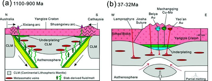
Figure 2. Metallogenic model for the formation of western Yunnan post-collisional porphyry Cu systems.
The perfect conditions for gold in the West Qinling Orogen
The West Qinling orogenic belt in Central China has an abundant supply of gold ore, but most discoveries of gold deposits in the region only took place during the last four decades. Located between the North China and South China cratons, this orogen now represents one of the most prospective gold provinces in China. With over 500 tonnes of gold reserves identified, it holds a great deal of potential for the future. However the nature of gold formation in this region remains a contentious issue.
Previous research in this region has examined the conditions behind gold formation with a view to aiding exploration targeting efforts, but has not considered factors affecting preservation of the deposits within the Earth’s crust. Gold ore is formed underground and over millions of years through a combination of uplift and surface erosion, bringing the ore to within mining levels (exhumation). It is therefore not sufficient for industry to simply conclude that an area has the right conditions for gold mineralisation. If there has been too much erosion the gold will have been destroyed, but if there has not been enough it is inaccessible. Part of Qingtao Zeng’s research tests this link between different mineralisation styles and the exhumation history of their host rocks.
The two major gold mineralisation styles that have been reported in the West Qinling Orogen are (1) orogenic gold and (2) Carlin-type gold mineralisation. The Liba goldfield and the Dashui gold deposit are selected to represent these two styles. The work on the Liba and Dashui gold deposits has been published online and submitted to Mineralium Deposita.
The exhumation history of the deposits has been examined through thermochronology and a comparative study was conducted to understand how and why there were such huge differences in mineralisation profiles. Thermochronology is a subfield of geology where the time that a sample has spent at a particular depth in the Earth’s crust can be determined. The technique combines radiometric dating and a knowledge of the closure temperature for different isotopic systems in individual minerals, to derive a geothermal gradient. The results from this research tell us that in the Liba area, exploration should focus on relatively deep expressions of gold mineralisation, because approximately 5 km of overburden has been eroded away. In the Dashui area, however, erosion has been much less, and a higher priority for gold exploration in the region should be given to shallow mineralisation styles. 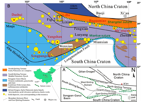
By using the knowledge acquired through this research, exploration companies can determine both whether the ore is accessible and what style it will be. After all, “you can only find what you are looking for”. In summary, Qingtao’s study has increased our understanding of the localisation of gold mineralisation in terms of both genesis and preservation, providing a tool for designing exploration strategy in the West Qinling Orogen.
Contacts: Qingtao Zeng, T. Campbell McCuaig
Funded by: Peking University
Figure 1.